Tuesday, August 29, 2023

Hike: McNeil Point, Mt Hood, Zigzag, OR


Getting There

I took Hwy 26 from Portland to Zig Zag and turn left onto E Lolo Pass Rd. After 4.2 miles, turn right onto Muddy Fork Rd. After 0.7 miles it becomes 1828. Continue for another 5.6 miles until the paved road changes to dirt & gravel, veer right. The Top Spur trailhead 1.5 miles from the last junction.

The Hike

Length: 8.91 mi
Elev. gain: 3,068 ft
Moving time: 4:24:35
Avg pace: 29:42
Calories: 2,667
Total time: 5:04:41
Steps (Fitbit): 25,244
Floors (Fitbit): 347


I knew weather was changing quickly and rain was forecast in Portland on Thursday. I wanted to get one more good hike in before my MSH summit next week. When I checked the weather at Zigzag, it look like just a light drizzle and overcast but I was not expecting such a wet environment.

The drizzle made the forest and ground wet. Water was puddling and streaming down the middle of the trail. I had to be careful stepping on the roots and rocks.

When I reached the PCT/Timberline Trail junction, I filled out the form and slid it into the slot on the box. The dirt on the trail was only wet on the top and I could see fresh tracks from hikers doing the Timberline Loop. It also stuck to my boots but didn't compromise my traction. I made sure to follow the "three points of contact".

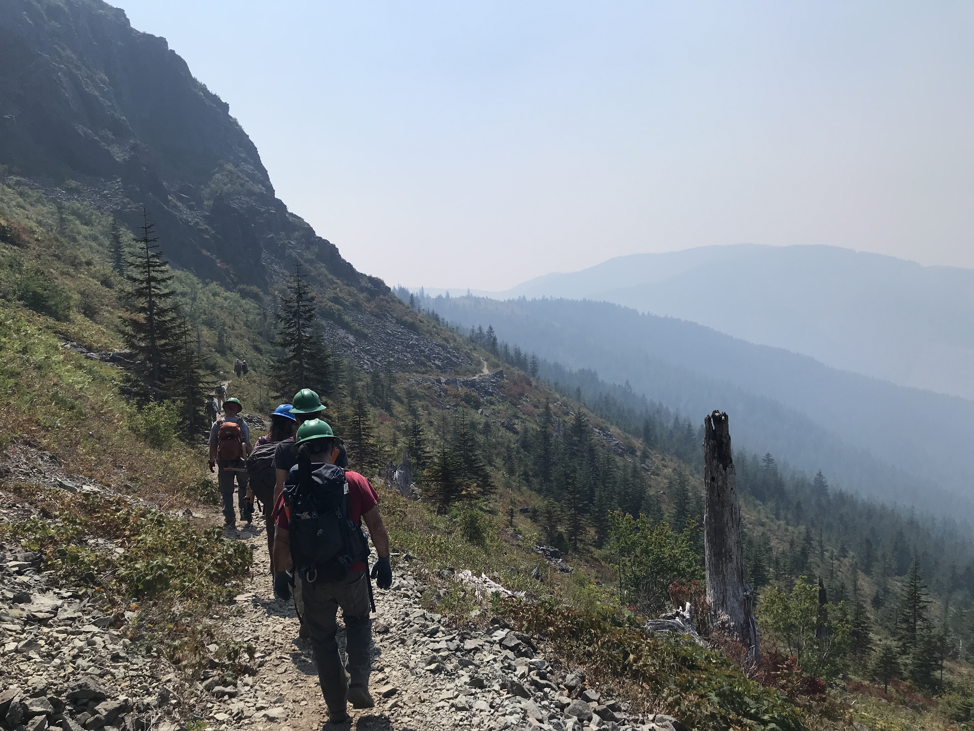
I crossed paths with several hikers who looked prepared but also a bit surprised by the sudden change in weather, considering we've had a hot, dry summer and there are dozens of wildfires, including nearby at Bull Run.

I noticed a burn smell but as far as I knew, the air quality was good. I wondered if it was burn, wet trees giving off the scent.

When I passed the McGee Creek Trail junction, I felt like I had the place to myself. With the fog or low clouds, it was a bit eerie but I tried to appreciate the solitude. 


Even with over 1000 miles on the trail in the last couple of years, I still feel apprehensive when I start a new hike, esp. when it's a remote trailhead. When I was driving up, I almost considered bailing on the hike if the Top Spur TH was empty but it wasn't: there was one other car in the lot and another about 100 yds away, likely overnighters. As I greeted more people, my nerves calmed down. I knew I had bear spray but not sure how I'll react if I actually have to use it one day.

I laughed that Mt Hood was no where to be seen but I reveled in the typical PNW hiking weather, I'd been waiting for the season change all summer. Nevertheless, a part of my kind of wished from some warm, clear skies without the wildfire smoke. It's still likely until October. I'm hoping for good conditions at MSH next week. 

I talked to the birds and named several boulders Dwayne.

Last time I was on this trail, there was quite a bit of snow in the last section of the McNeil Point Trail. In fact, I took the steep route up and down last year. This time around, I wanted to experience the roundabout route. It was gorgeous. There were dozens of awesome camp spots along the way and by the two, now dried, lakes. 


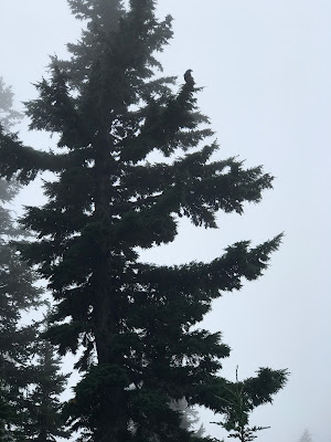
I saw some fly agaric mushrooms and Western Pasqueflowers and a crow that was squawking above me.


After I reached the Timberline-McNeil Point junction, I passed another pair of hikers going the other way.

I imagined the epic views of the mountain somewhere above in the clouds.


The trails climbs up a ridge and through some talus fields. In one of them, I critter (mammal or bird) was somewhere nearby upset by my presence. I guessed I was too close to it's burrow or nest. I talked to it calmly and moved on.

I finally reached the ridge and could see the McNeil Shelter. I'd made good time up here and still had some energy to spare. Cathedral Ridge and Ho Rock was somewhere above and I adopted the "let's see how far I can make it". It was longer than I remember but I continued on, an analog of next week's climb. It was windy and a bit rainy. In hindsight I was close to the end of the trail (600 ft and 0.3 miles) but I turned back.

On the descent back to the shelter, my knees were hurting which gave me pause. I still had the entire return trip back to the car. I stopped at the shelter to eat my sandwich and refill my easy access water bottle. My right knee was really barking and I rubbed it to try to feel better. I was going to take the steep trail down to save some distance but I knew I taking a small risk as well.

Less than 100 ft into the descent, I met a hiker coming up the trail. This alleviated my concerns and I felt energized to continue. Call it bravado or saving face, it just refreshed my self-confidence. Seeing others out there seems to do that for me. I love the solitude but not too much. It's probably while thru-hikers tend to buddy up with others. As a solo hiker, I worry about injuries and wildlife that would probably be less daunting with a partner. I'm not comparing myself to YouTubers like Joey Coconato who have tons of outdoor experience but it gives me a goal to shoot for. I've never done an overnighter since I started hiking again, and in fact since I was a kid in Canada with that group. I admire folks who set out alone to do the Loowit and Timberline Loops.

When I reached the Timberline Trail again, I was feeling good. My knee had calmed down and I was recharged to continue my hike back to the car. I was soaked but knew it'd be okay since I had dry clothes at the car and in a pinch had dry clothes in my pack.

I passed several more overnighters on the trail and said hello to all of them.

On the last segment of the trail back to Top Spur, a younger guy asked about water sources. I said I hadn't been on the lookout but offered some hope that were must be some streams, esp with the rain and damp conditions. The reality is I didn't know for sure. The puddles and trickles on the trail weren't viable options unless it was dire. I marveled at this guy confidence and maybe his naivete. There was certain water 4 miles away at Glisan Creek. He was just 1/4 mile from the car and hadn't thought about water? Bizarre but not my problem.

I was glad to reach the car and get out of my wet clothes. I only had my rain pants (which I had stupidly not put on) to wear on the way home, plus several dry shirts to choose from.

These images don't show the full picture. My jacket under the rain coat was drenched. My pants were wet all the way through from rubbing against bushes laden with water. 


The drive back to Zigzag was uneventful and I was glad to be back on Hwy 26. 

A gorgeous, successful outing.

Wednesday, August 23, 2023

Hike: Mt Adams South Climb to Lunch Counter, Trout Lake, WA

8,441 feet

Getting There

Wow. What an adventure! Total travel time was 3 hrs from my places to the trailhead. Google estimated 2h30m and Apple had it at 3h30m.

I took I-84 east to Hood River and crossed the Columbia River. Turn N onto WA-141 N to Trout Lake. From there, take Mt Adams Road to NF-80. To this point, I was on pavement but when you get to NF-8040, that's when the "fun" begins. It's about 3-4 miles of washboard. Ack! Brutal on my Jeep, esp after a rough spring and summer with multiple visits to the mechanic for a variety of issues. I tried to weave through at around 5-10 MPH but it was relentless.

I was actually relieved to get to a sign that said Rough Road Ahead. The next 3-4 miles was rutted and deep holes. More than once I second guessed my choice to come out there. I passed a guy that was camping right on the road. I tried to keep the dust down and said "good morning."

I took my time and hoped I would have another car coming down and we'd have to squeeze past each other. Ultimately, I had the road to myself.

At Morrison Creek Campground there's a gooseneck turn and the road changes to NF-500. This is the final stretch and it got even more interesting. There's a snow gate and sign that warns the road from there is steep and narrow. "Please no cars coming down!" There weren't but a couple dozen deep trenches for erosion control. Fortunately, I negotiated them just fine and never bottomed out.

Near the top, I saw a Suburban in my mirrors. I figured I'd pull over and let them pass. I was being extra cautious. A few turns later the Cold Springs Campground came into view. The trailhead is on the left and there's additional parking near the campground. The Suburban took the last spot so I continued a bit further and found a spot. Whew! I made it.


The Hike

Length: 7.26 mi
Elev. gain: 2,838 ft
Moving time: 4:02:06
Avg pace: 33:20
Calories: 2,440
Total time: 5:12:34


The air was brisk. I put on my long-sleeved shirt over my hiking shirt. I knew I wasn't summiting but considered taking at least 1/2 the water in the 6L bag. Two teens from the Suburban were taking turns using the vault toilet while the rest of their crew got ready.

I locked everything up and set out. I stopped at the trailhead, a bit surprised there wasn't a Sign In book like at Climber's Bivouac. I chitchatted with the family of 5 and we all set out. Within 100 ft, they stopped to let me pass. I wished them a good hike and zoomed past.

At Morrison Creek you reach the timberline. It's 1200 ft of elevation gain over 2.2 miles. Not bad. It's a decent trail but really rocky. Fortunately, there's a dirt path that weaves through the rocks.


I missed the trail and started climbing up instead of crossing the creek. I pulled out the map and rerouted. I could hear the family 100 yards behind me.

The trail climbs through rocks and a stand of trees. It's 1/2 miles and about 500 ft. I passed a woman and her dog and then, another woman and her dad. The trail is well-marked with lodge poles. There are signs that say the route varies in different conditions so I just sighted a lodgepole and chose a route to it.


It wasn't terribly difficult but slow going due to the terrain. Eventually, you're out of the trees and making your way up to Lunch Counter.


At several of the lodge poles there were rocky clearings for camping. It reminded me of the rock walls on Wind Mountain but in this case their for bivouacking on the climbing route.

A bit further up a white mountain goat was foraging in the rocks but by the time I was adjacent to it, the fella was resting and looking around. 


I finally reached a lodge pole and large patch of snow. It seemed the trail went right through it. Lunch Counter was still another 900 ft of elevation and 0.7 miles above me. About then, the family of 5 from the Suburban arrived there as well.

8,441 feet

I saw a path of footprints in the snow but decided to take a rest and eat my sandwich. I wasn't sure if the snow was stable and if there were soft spots to be concerned about. I would have had to find some tracks to be more confident.

The family said they only had 3 sets of crampons for 5 people and that this was likely as far as they were going to go. They told me the woman and her dad had camped somewhere around here.

After I ate, I wandered to the edge of the snow and realized the foot tracks were not fresh. Hmm. There must be a path that skirted around the snow patch. I picked up some trash and when I got up, I was a bit light-headed. Definitely, not quite acclimated to the altitude. 

While I didn't quite reach Lunch Counter, I was glad to have reached this point. Definitely need a bit more experience to summit this mountain but it's not out of reach. I have most of year to get ready and maybe find a climbing partner.

Successful day. I chitchatted with the parents for awhile and talked a lot about Mt St Helens and my volunteer role.


I knew I had a bit a climb down and then a long drive on that rough road so I set out down the mountain.

Actually, the descent was a bit easier. I'd got a little offtrack near my stopping point and it was easier to stay on the trail seeing it from the downward perspective.


After 100 yards I looked back at where I'd come from and noticed a pair of climbers crossing the snow patch. They were higher up than where I'd stopped. 

Eventually they caught up and passed me as I snaked through a stand of trees. They had camping gear, helmets, crampons, ice picks, and Scarpa Climbing boots. Yep. I've read trail reports of people doing the climb in trail runners and microspikes but that probably comes with years of experience.

Down by Morrison Creek, they were stopped. One of them was changing out of the heavy-duty boots and putting on open-toed sandals. Brave soul. I would have stubbed my toes in 10 feet. It's why I love my Keen sandals with the toe guard!

I passed some day hikers that were exploring off the trail and two sets of climbers that were decked out in the all the necessary gear.

The Drive Down 

Again, I was concerned about having to negotiate around cars that were coming up the road but fortunately I didn't happen on the narrow, steep section. 

At a wide section, I pulled over when I saw two cars coming down the road behind me. It was a sedan and those two climbers I'd seen on my descent in a lifted pickup. There was one car coming up, a Subaru. The driver and I waved at each other.

At Morrison Creek Campground, I took a spin around.


I made it through the erosion control trenches and ruts & holes. I hated reaching the washboards. It sucked. I thought about my poor Jeep taking the abuse. I keep the speed down to 5-10 mph but still it vibrated the vehicle. At wider spots I tried an S pattern so that the 4 wheels were hitting the lateral ruts at different times. I noticed my phone in its mount on the dashboard was shaking less violently. A few trucks came up the road and one guy on a motorcycle with no helmet.

I was so relieved to see my navigation app (Google) show NF-80 in 1.4 miles. That meant pavement. I watched the distanced to it decrease until I saw the junction. So happy to be on pavement.

Maybe when I do the climb, I'll advocate to take my future climbing partner's car!!


Saturday, August 19, 2023

Hike: Grouse Vista Trail to Silver Star Mountain, Yacolt, WA


Getting There

This was a momentous day. The last time I was on the L-1200/L-1201, I got a flat tire. I'd been on my way back from trying to visit the Noble Ridge Tree Deck up L-1201 and ran over a bullet shell. I was able to limp all the way back to the Washougal River Road and about 8 miles from town but ultimately, I had to get a new set of 5 tires. Ouch! That was back in May.

Most recently, I attempted to get to the trailhead from the north, Moulton Falls route but Google Maps did me dirt! It was trying to route me on forest roads that were gated closed. I was on L-1200 but 6 min from the trailhead the estimated time when from 15 mins to 1h45min! WTaF? I panicked and just turned around. I ended up going all the way up to MSH and hiking the Loowit Trail via June Lake.

To get there from the south take L-1200 out of Washougal to get there. It's 7 miles up a gravel road from the end of the pavement on Skamania Mines Road and it's 18 miles from Washougal.

"Head north on Washougal River Rd toward 6th Ave/F St (10 min (6.5 mi)). Continue on NE Hughes Rd. Take Skamania Mines Rd and 1200 Rd to L-1200 (32 min (11.5 mi))."

I was there for a WTA (Washington Trails Association) Trail Work Party that I'd seen a post for on the Mt St Helens Institute Facebook page. It was right up my alley so I signed up.

We met at the trailhead at 8:30am. Actually, I'd left around 7am and made it there by 8:15am. The crew leader talked to us 8 volunteers for about 30mins about tool usage, safety, and what to expect & what we were going to be doing. Five of the volunteers had their own hardhats and the other three of use had loaners with tape on the side to put our names in pen.

There were a couple of seasoned volunteers that were the assistant crew leaders. We'd be in 3 subgroups. One person was a MSHI volunteer as well and donned this year's shirt. She was celebrating her 600th work party with WTA! After the orientation talk, I got rid of my straw hat and stowed a pull saw. I grabbed the loppers that I was to carry to the work site.

The Hike

Distance: 3.77 miles
Elevation Gain: 1,200 ft


At around 9am, we started up the trail. It's a steep, rocky section but I was in good shape and adopted a slow steady pace.

We'd stop periodically to let everyone catch up. Eventually, we found some things on the trail that needed attention: small branches protruding over the trail. I made my first cuts.

Making the cut

Making the cut 2

A subgroup was going to saw a big log that was layed across the trail but I was in the group that continued on. At the unofficial trail junction to Pyramid Rock, we stopped for a water break and chocolate.

Along the way, we ate berries (blueberries, huckleberries, thimbleberries) along the way and chitchatted. 

We finally made it to the work site, a 1-mile section of the trail below Pyramid Rock. There were several squeeze points where we pruned bushes and trimmed protruding tree branches. We'd work for a bit, then continue up the trail.

Soon it was time for lunch. We found a place for everyone to site off the trail and eat. There wasn't shade but it was good to take off my hard hat and backpack.

At that point, the wildfire smoke from Canada and Eastern WA was started to envelope the area. It was also getting warm and I only had my Hike-a-Thon cotton t-shirt. I changed into my long-sleeved, button-down shirt and filled up my water bottle from reserves.

Grouse Vista Trail

Pyramid Rock

Smoke beginning to roll in

Sturgeon Rock in the distance

After lunch was moved further towards the summit but were still 2-3 miles from the last junction. There was much to do in this section. Earlier I'd been asking what bushes and trees to trim and how much but by now, I felt confident to make wise pruning choices.

The crew leader finally gave the 10-min-more call. The smoke was getting dense and I was starting to feel it in my throat and eyes.

We called it a day and started back down.


Back at the place we'd taken our first break we stopped again to regather and take a group selfie.


Back at the trailhead, we gathered by the WTA truck and had soft drinks, chips, cookies, and popsicles!

Everyone worked together and was super friendly and welcoming. 10/10 will do it again!