Sunday, August 28, 2022

Hike: Stagman Ridge Trail, Mt Adams, WA


Getting There

From Hwy 14 across from Hood River, take WA-141 N.  Follow it for 19.0 mi, then it's a slight right onto Mt Adams Rd (signs for Sno-Parks/Recreation Area). Follow it for 1.3 mi, then continue straight onto Buck Creek Rd/NF-23/Randle Rd. Continue to follow NF-23 for 7.7 mi. Then, it's a slight right onto NF-8031. Follow it for 0.4 mi. Continue straight onto NF-070 for 3.1 mi, then turn right onto NF-120. The trailhead parking lot is 0.8 mi.

The gravel road is in pretty good shape, just a few potholes to keep an eye out for.

I didn't keep track of the time but I took I-84 from Portland. Google Maps estimated the trip to be about 2 hrs.

The Hike

Unfortunately, AllTrails app messed up again and I didn't get a recording of the hike. I was able to reconstruct it with the Footpath app.

Length: 10.6 mi
Elevation gain
: 2,182 ft
Steps
: 24,571
Calories
: 3,462
Floors
: 261
Time:
~4 hrs

This was my first hike around the Mt Adams area. I remember exploring somewhere around Trout Lake in my pickup when I first moved to the PacNW in 2003, but I always considered it off-limits to non-Yakamas except by permit, like to climb to the summit.

All these years later, I learned it's only partly true. The west side of the mountain is not on Yakama land and there are a few trails and the PCT passes by. However, the southeast side of the mountain is only open to non-Yakamas for about a month in Sept (Aug 29-Sept 25) for hiking, camping, fishing/hunting by permit. I'm fairly certain that you can get a permit year round for climbing, probably like Mt St Helens.

This was my final hike for the Hike-A-Thon. I considered going to an old favorite (Hamilton Mtn) or finally checking Table Mountain off the list, but I decided a new hike. I looked up Mt Adams and looked up the directions to the trailhead.

I remember my camping trip at Takhlakh Lake a few years back and giving a ride to a resident of Trout Lake.

The 2-hour drive from Portland was comparable to anything around Mt St Helens, from south or north, or even Mt Hood.

I got a later start than I'd have liked in hindsight. I still got to the trail by around 1pm.

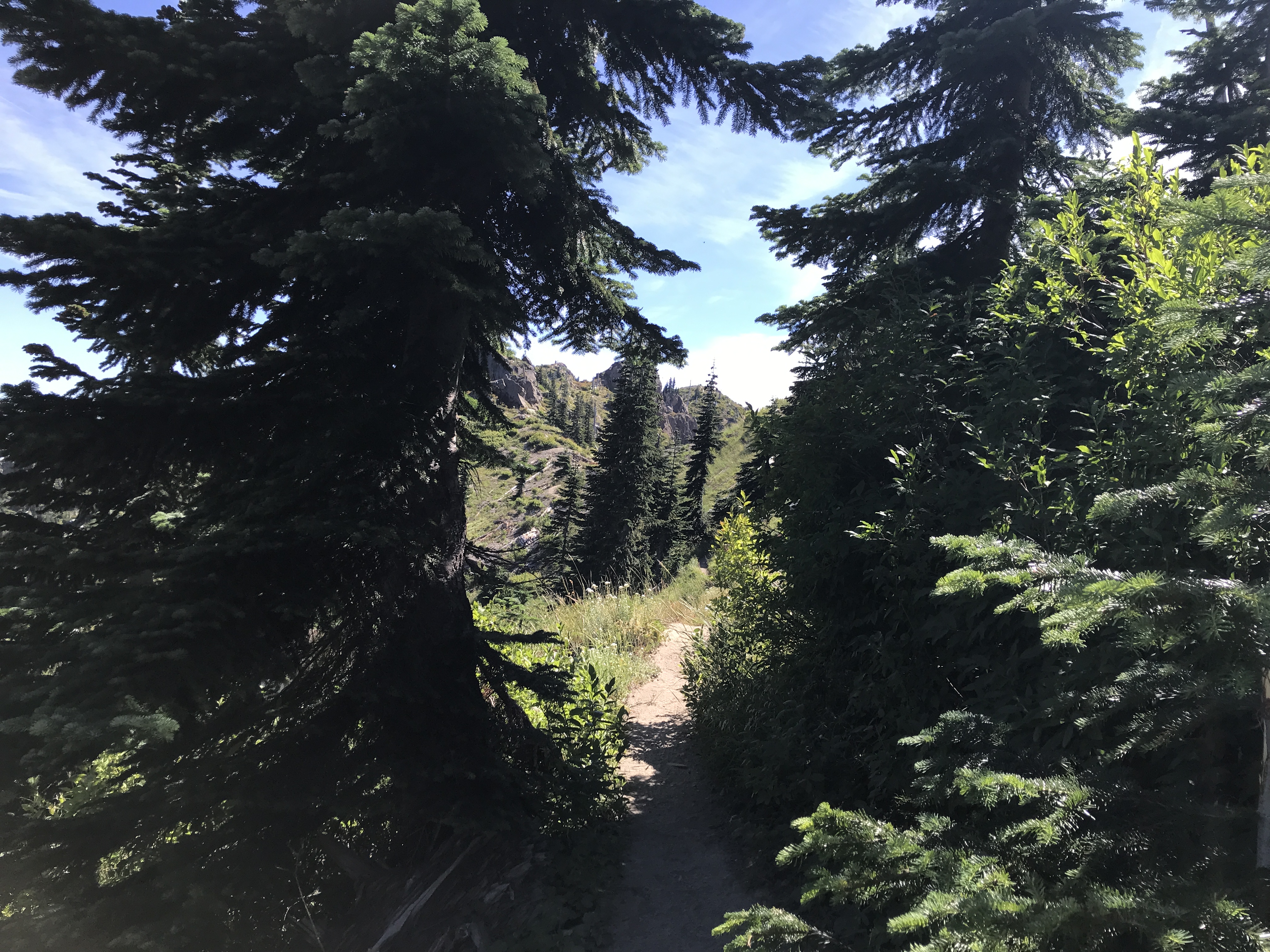
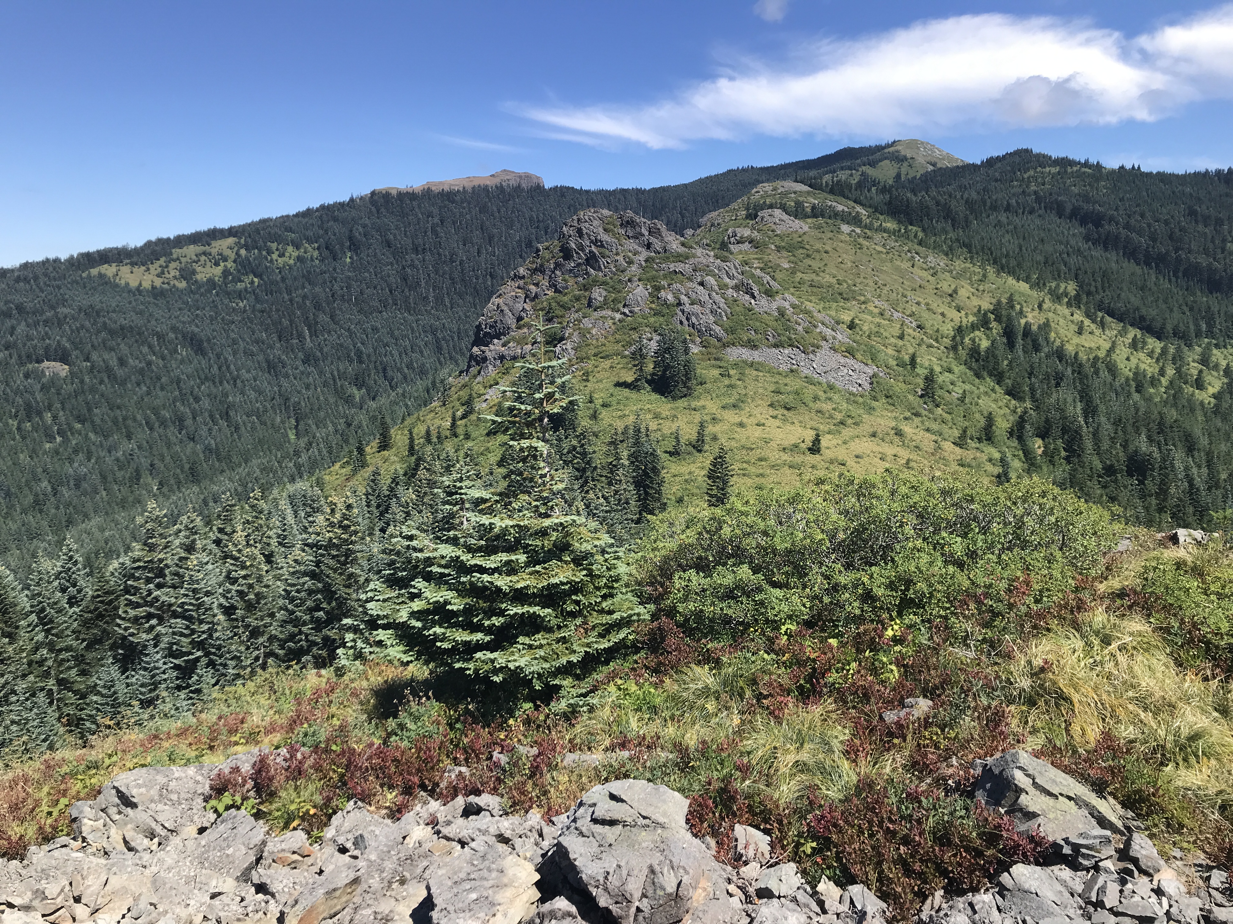
The hike starts in the forest but when you get to the ridge, you weave through an old burn. The trees are mostly dead, their limbs wrapped around the trunk like a dead insect. There's not much perceivable elevation gain but in the end, I did ~2000 ft of gain.

There were several pairs of hikers on my ascent; I mentally tried to estimate the groups to the number of cars at the trailhead.

I really didn't know what to expect. It felt a lot like the Vista Ridge or McNeil hikes at Mt Hood. I never made it above the treeline. Looks like it might if you follow the PCT North route.

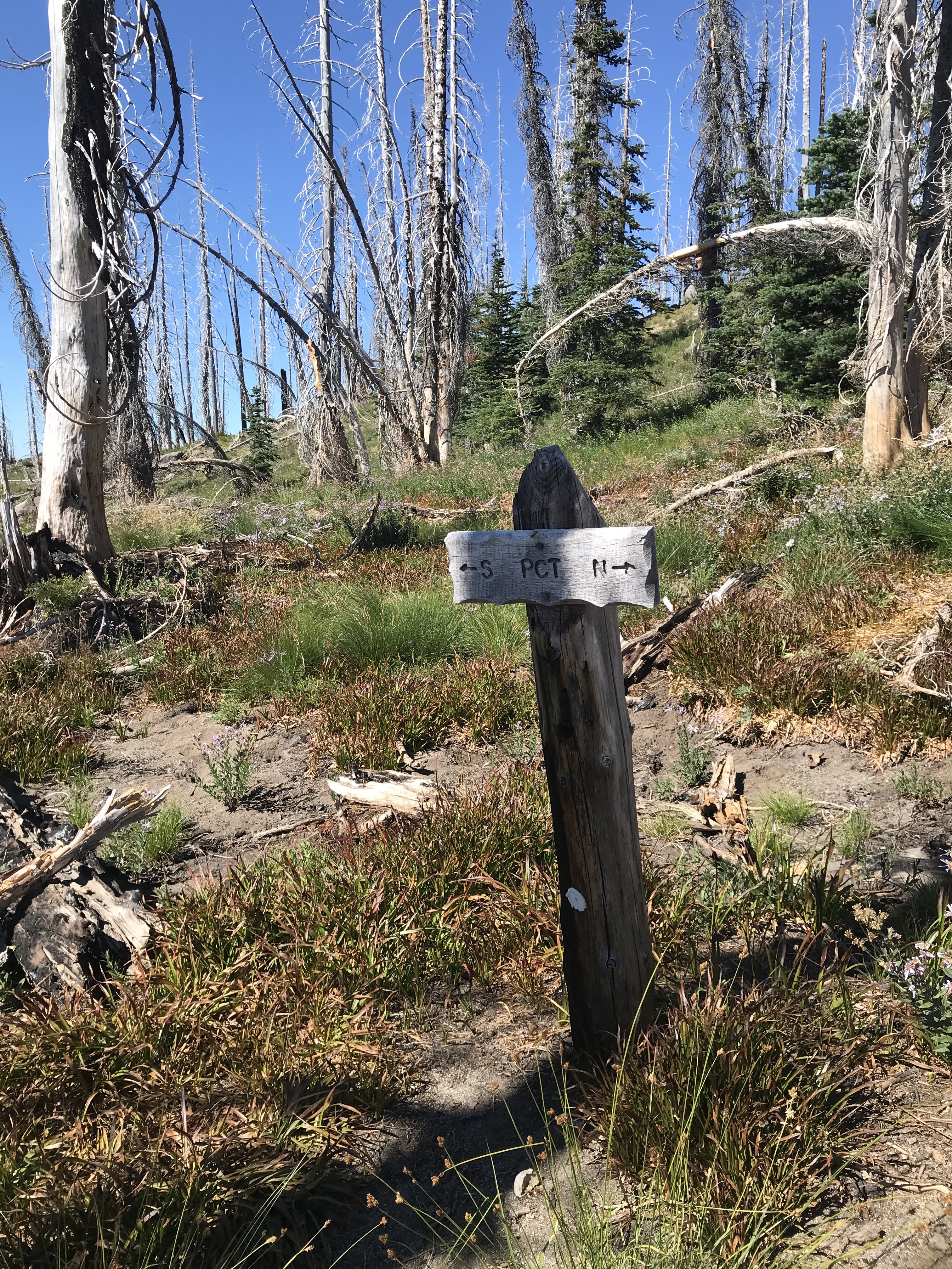
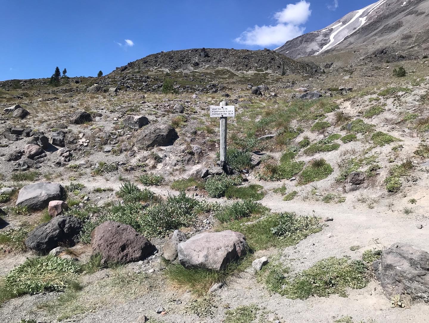
Around 3pm, I started thinking about turning back. I could see PCT junction so I figured I'd at least make it there. When I got there I looked at the map again and estimated I could actually complete the Lookingglass Lake loop. Seemed like it'd be downhill a bit so could make good time.

Not far from the junction, I passed a group of three. That gave me confidence to keep going. Near the PCT North junction, I passed another pair. I asked them about the loop and continued.

When the trail reached the edge of the ravine and started to down, I had second thoughts. I really didn't know what to expect and it was then around 3:30p. I stopped and went back the way I'd come. Even though it wasn't much longer to retrace my steps, at least I knew the trail.

I passed a guy before I reached the junction. I thought dammit, I could have done the loop. Oh well. Next time.

On the way back I caught up with the pair I'd talked to and eventually passed them on the ridge.

Not much further ahead I reached the trio. I tried to make noise by stepping on twigs and such. I stopped for a min or two to let them get ahead.

They had a dog that had stopped on the trail. I was able to pass them there. 

Back at the car, I sent my "I'm done hiking" message on my InReach. I put it on the bumper while I stowed my gear and changed out of my hiking boots.

I hoped in the car and put on some tunes. A good hike.

About a 1/2 mile I stopped. Fuck, I'd left the InReach on the bumper. I turned around and headed back to the trailhead. I passed two cars. I was pretty sure it had fallen off the bumper just a little ways from my parking spot so I didn't bother looking until I was close. I just hoped that neither of those cars had run it over.

To my relief, I spotted it face down in the gravel just a few feet ahead of my parking spot. Hooray! it has a couple of scratch on the plastic but the screen is fine.

I look forward to going back and exploring some other areas.


Sunday, August 21, 2022

Hike: Coldwater Peak via Boundary Trail, Toutle, WA

Getting There

Take I-5 from Portland to Castle Rock. It's 55mi from Kenton to the exit 49. There are a few gas stations to fill up here. 

It's 62 miles to the Johnston Ridge parking lot/trailhead and it takes about 1 hr. 


The Hike

Length: 13.98 mi
Elevation gain: 3,228 ft
Moving time: 5:47:00
Avg. pace: 24:49
Calories: 3,484
Total time: 6:42:58

Fitbit
Steps: 34,316
Calories: 4,419
Miles: 15.76
Active Mins: 147
Floors: 402

This was my 3rd hike for WTA's Hike-a-Thon and my 2nd visit here in '22. Last time I did the hike, I didn't quite make it to the top due to mountain goats and quite a bit of snow. I'd also gotten a late start and was pushing my limit on return time.

The Sunday weather was warm but virtually clear. I'd originally planned to hike to Loowit Falls but just before crossing under Harry's Ridge, I took a detour to Devil's Elbow to get a final look before I had to decide. I could see the waterfall or at least where it should be. I got a good look at the terrain and considered the temperatures, and opted to take a run at Coldwater Peak and get some elevation instead.

My previous visit was on July 2, 2022 and there were still large patches of snow. I wore microspikes from the Coldwater Lake Trail junction and beyond. Nearly two months later, I had dirt the entire way. I looked for the place where I met the mountain goats but it looked different without the snow and all the new vegetation.

At the summit, another hiker was having a snack so waved and kept going to the north end of top. I took off my pack for a bit and took some photos. 

When I did the hike on July 8, 2021, a thick cloud bank had rolled in and enveloped the peak and valley below MSH. The weather had been clear on the hike out there. I waited up there for 10-15mins but it didn't budge. About 1/2 way down to the Boundary trail, the fog rolled out. I considered going back up but I needed to start heading back.

This time the weather was amazing. I could see all the Cascade Peaks: Mt Rainier, Mt Adams, Mt Hood, of course Mt St Helens.

On my descent I passed a couple that were heading to the top but looked tired. I tried to be encouraging and cheerful and mentioned that "the Man of the Mountain will keep them company". If they didn't know I was referring the hundreds of white pasqueflowers that were growing on the mountainside, it might have sounded like a creepy thing to hear from a rando hiker. LOL.

My visit wouldn't have been complete without a stop at Harry's Ridge. There was a couple top of the ridge, the woman taking photos. I meandered around for a bit and they eventually started on their way. I had the place to myself for awhile. A group of four were winding their way up the ridge but not quickly. I was so quiet and peaceful. Just the buzzing of a few flies, the blowing of the wind but nothing else.


Gallery


Coldwater Peak

Coldwater Peak

Selfie w/ Loowit

Mt Rainier

Mt Rainier

MSH

Mt Adams

St Helens Lake & Mt Adams

Johnston Ridge

Mt Adams

Coldwater Peak


Sunday, August 14, 2022

Hike: Silver Star Mountain via Grouse Trail, Yacolt, WA

AllTrails maps

Getting There

I took L-1200 out of Washougal to get there. It's 7 miles up a gravel road from the end of the pavement on Skamania Mines Road and it's 18 miles from Washougal. You can also reach the trailhead from the north via Yacolt.


The Hike

Length: 8.14 mi
Elevation gain: 2,539 ft
Moving time: 3:38:58
Total time: 3:54:39
Avg. pace
: 26:54
Calories: 1,929
 
This was my third time up this trail. The weather was amazing. Not too hot, very few bugs, trail was mostly free of obstructions like overgrowth and trees. The first hill is long and rocky and could be tedious but there are a lot of decisions to make, i.e. picking a route through the rocks.

I took a look at a side trail around Pyramid Rock and got some elevation. On my previous visits, the weather has been a little overcast so it was great to get above the trees and see outcrops above.

There are a lot of folks enjoying the views at the top. I did stop for a 10-15 mins to eat part of a sandwich and take some photos. I also had to change into a dry shirt.

I started down the trail to Sturgeon Rock. According to the map, there is another trail which I looked at but it was overgrown. I tried the more direct route but found it pretty steep and rocky, like a creek bed. I just didn't want to lose the elevation and decided to stick to the main trail.

On the map, you can make a cool loop by detouring to Sturgeon Rock then descending down to Tarbell Trail which reconnects with the Grouse Trail a few hundred feet from the trailhead and L-1200.

Grouse Trail

Looking west

Pyramid Rock (fg), Sturgeon Rock (bg/L), Silver Star Mtn (bg/R)

Mount Hood (Wy'est)(L), tip of Jefferson Mtn (R)

Sturgeon Rock
 
Silver Star and Mt St Helens (R)

Pano of Pyramid Rock

Pano from Silver Star Mtn


Saturday, August 13, 2022

Hike: North End of Forest Park 19, Portland, OR

AllTrails map


Getting There

Take NW Skyline Blvd north from NW Germantown Road. The Skyline Blvd Trailhead is 1.6 mi and a parking are available on right (east) side of the road.  

I've been slightly wary of parking at popular hiking trailheads since hearing about the rash of break-ins at the Newberry Road Trailhead (N end of Wildwood Trail) and my own debacle at work. Sucks. Nevertheless, I figured I've done all I can do like locking the console and glove-box and not leaving any of valuable visible or stuff in the back like before the break-in. I parked in a highly visible area and (knock on wood) no issues.

Since the last time I was here, a plastic lawn sign was added warning about "prowlers".

The Hike

Length: 7.30 mi
Elevation gain: 1,699 ft
Moving time: 2:33:34
Total time: 2:38:39
Avg. pace: 21:03
Calories: 1,353

Steps: 22,436
Zone Mins: 37
Floors: 240
Calories: 1,606

This was my first full loop hike since June. I was happy to finally not have to deal with mud. There was a little bit of overgrowth but manageable. I skipped the detours this time which cut the hike down 500 ft of climb and 3 miles.

The 800 ft climb up BPA Road took 25 mins, on par with my previous times. I'm feeling good physically about my 2nd MSH climb next month. The new boots are giving me some troubles but I'm going keep trying to get them broken in. Just in case I'll take both pairs to the trailhead and decide on hike day.

I should have hiked in WA for the the August Hike-A-Thon but I made the decision late. As I write this on Sunday morning, I'm wondering if I have a second hike in me this weekend. I'll have to get going soon.

Saturday, August 6, 2022

Hike: Butte Camp Trail via Red Rock Pass Trailhead, Cougar, WA

AllTrails map

Getting There

Take I-5 North to Woodland. Then take WA-503 (Lewis River Road) to Yale Lake. One way to get to the Red Rocks Pass Trailhead, take the left turn for Merrill Lake - NF 81. If you reach Cougar, you've gone passed it. It's a peaceful drive along Merrill Lake (even though you can't really see from the road.) Watch out for a 90-deg right turn just after Goat Mountain because if you go straight, it becomes Forest Road 8123 (dirt) and if you turn right you continue on NF-81 (paved) (Merrill Lake Road).

Another way to get there is pass through Cougar and take the left turn for Ape Caves/Ape & Lava Canyons (NF-83). Then, take that for awhile. After passing through a huge clear cut area, take a left toward Climber's Bivouac (NF-81). Follow that road (partly paved until NF-830, then it's dirt/gravel) until you reach Red Rocks Pass Trailhead.

There is room for about 4-5 cars to perpendicular park near the sign and then, plenty of room for parallel parking on the shoulder. Be sure to show your WA Discover Pass (or equiv).


The Hike

Length: 7.74 mi
Elevation gain: 1,736 ft
Moving time: 2:53:55
Avg. pace: 22:28
Calories: 1,532
Total time: 3:11:06
Fitbit
Steps: 23,122
Calories: 3,409
Miles: 10.62
Floors: 215

It was good to be back out here. I came in late spring via Merrill Lake and had to turn around somewhere around the Kalama Horse Camp due to heavy snow on the road and I was traveling solo.

A few months ago I had a weird David Lynch-esque dream that was loosely based on this location. I was kind of surreal to see it IRL and still be able to conjour the dream imagery and see how different it really was but how some of the topographical elements were distorted and represented.

I hiked trail last year on Oct 30, 2021 minus the off-trail detour/oopsie. It was warm but not terrible I was in long pants in case of bugs and long sleeved Kuhl shirt w/ 40 UPF coverage. Also, I was sporting my signature straw hat. I had about 4L of water to boot.

I bought a new pair of Keen Targhee III on Friday for $20 from the Keen HQ Garage Yard Sale. It benefited Love Is King ("Love Is King squashes the fear in the outdoors and provides equitable access and resolute safety to ensure an enriching and exhilarating experience in nature.") and Forest Park Conservancy ("Forest Park Conservancy's mission is focused on protecting Forest Park's ecological health while encouraging responsible recreation and access.").

When I got my first pair of Tarhee IIIs in 2020, I drove from the REI in Tualatin to the Grouse Vista Trail and hiked to Silver Star mountain. They worked out of the box: no blisters and minimal discomfort. The same was mostly true for this new pair. I did have some issues w/ my right foot. The left side was dialed in perfectly but I noticed an issue w/ the left side that I couldn't seem to fix; either too loose or too tight and slipping inside a little. I must have stopped 4-5 times to re-adjust and still wasn't happy with the fit. I know as the shoe is less stiff and form-fitting, it'll be good.

I didn't see enough people to correspond to the cars at the trailhead. There are a bunch of route options like heading west towards Blue Lake or doing the whole loop via Sheep Canyon. There was a couple camped before the big climb/switchbacks so probably others campers out there. 

It was pretty hazy in the distance which made it difficult to see Mt Hood. Still gorgeous panoramic views as you can see below.