Showing posts with label Cook. Show all posts

Wednesday, February 11, 2026

Hike: Dog Mountain via Augspurger Trail, Cook, WA

Getting There

The Augspurger and Dog Mountain Trails share the same trailhead parking lot off Hwy 14. 

I took I-84 to Cascade Locks, then crossed the river and continued on WA-14 eastbound. It's 54 miles (87km) from Portland and 6.2 miles (10km) from the Carson turnoff/round-about. Being a mid-week hike, the parking lot was mostly empty, save a few cars. 

I parked by the Discover Pass sign and geared up. After a pit stop, I set out on the trail, remembering my hike from last November.

The Hike

Distance: 6.92 mi
Ascent: 2,743 ft
Total Time: 3h 46m 


This was my second hike of the year and my first "real" hike: decent mileage and elevation gain. 

I was settling into my groove but was quickly jolted by something on the trail. It was a dead deer on the trail. Sorry for the graphic details: it was on its back with hind legs in the air. It was just leg bones, the flesh had been eaten off. My mind went from "holy shit, this is gruesome" to "I hope there isn't a cougar or other predator or scavenger watching me, ready to defend its meal." I hestitated, trying to gather the courage to proceed or return to the trailhead and take the Dog Mountain Trail instead. As I stepped over the carcass, hundreds of flies took flight. I tried not to look too closely and burn a horrible image in my mind. I noticed some poop and entrails near the body. 


I cleared the body and quickened my pace. I had to get out of there. When I reached a viewpoint of Wind Mountain about 3-4 mins up the trail, I texted James about who to contact. He got back to me and said to forward to Stasia to message our forest contact. I was just thinking about unsuspecting hikers coming across the scene and possibly having an animal encounter.


The weather was great. I kind of hoped to meet a hiker coming down the trail but never saw anyone. Too few people around. I was preparing my spiel about the deer.


Snapshots of the trail from when I was there for the WTA work party popped into my mind, helping me gauge my progress. I wasn't terrible energetic, taking more breaks than I'd expected to need. Thank goodness for my electrolytes, they kept me going.

I was having doubts but didn't want to turn back and have to go by the deer again. (shudder). It gave me some motivation to push myself.

I was relieved when I reached Augspurger-Dog Mountain Trail junction. I poked my head around the corner on the Augspurger Trail. I want to check it off the list sometime. It's a long one, 12.3 miles (~19.8km), 4507 feet (1373m), maybe a good conditioning hike for MSH or Mt Adams, etc.


As with other hikes I've done, I've compressed the next section in my mind. It's longer than I remembered and a little more elevation gain. I encountered a few downed trees over the trail.


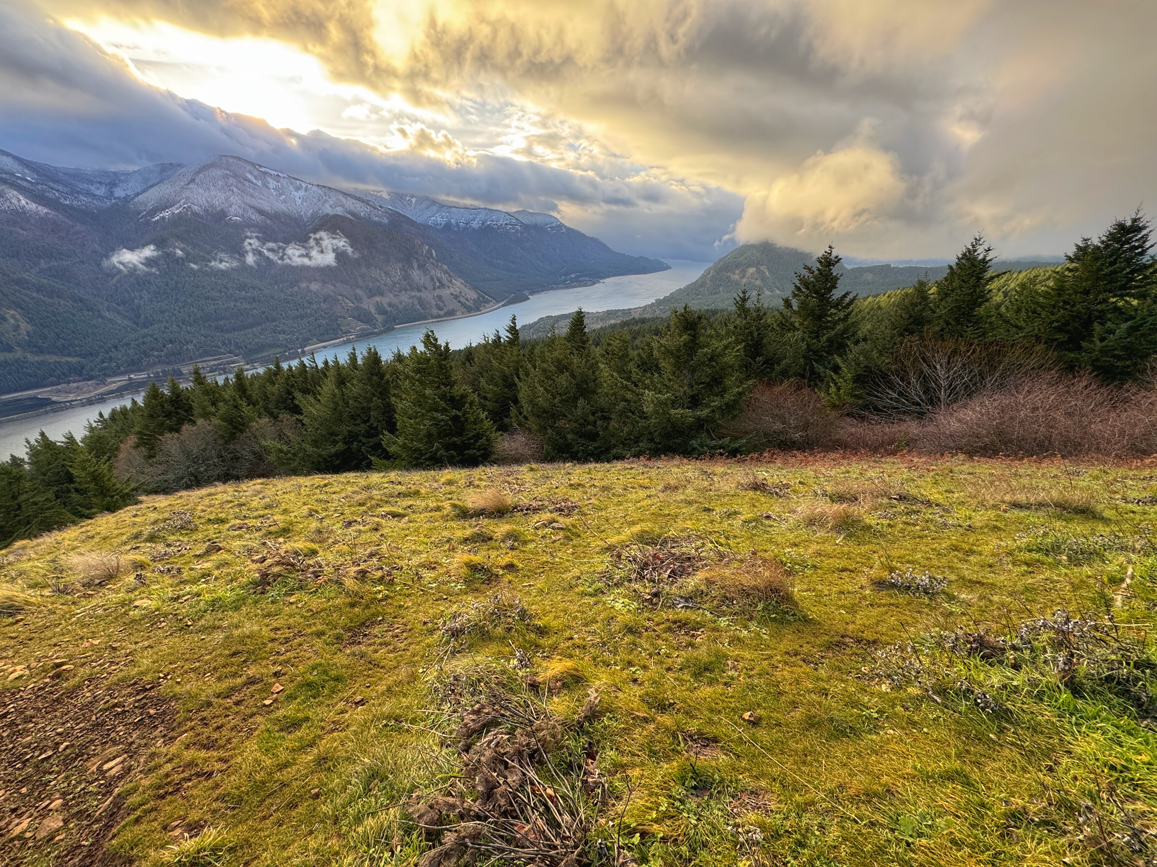
I finally emerged from the trees and I could see to the Dog Mountain Trail. I was almost to the apex of my hike. The views were spectacular. The sun was still a bit high in the sky, the lighting still a bit bright. Someday I'll hike here when the wildflower are in bloom.


On my descent, I passed a hiker coming up to the summit.


I made sure to enjoy the views after the difficult ascent and trace of doubt. 


After Puppy Dog Point, I passed another solo hiker. I passed another couple in the trees, and a pair of hikers past the Hard/Very Hard routes. I thought about folks that hike late in the day. I wondered if they had the 10 essentials including a light source. 

I took a picture of the Mitchell Point. Awesome to see it from this side of the river. 


I was elated to have made it to the top and I was making good progress down (knees intact). 

I finally reached the lower section, the switchbacks. I inspected our trail work from last year. I tried to find that section that were excavated and filled in. It was invisible :)


Back at the parking lot, I counted the cars and matched them in my mind with the hikers I'd seen.

A successful day. I'm still pretty fit for the terrain and difficulty. It it motivation to resume my hiking frequency, balancing trail work with personal hikes.


Sunday, September 1, 2024

Hike: Monte Carlo Trail, Cook, WA

Getting There

We were staying at the Oklahoma Campground so the commute to this worksite was very close. The original plan was to move everyone's car to Site #6 but our Crew Leader found there was enough room for everyone to park by the trailhead, then we could relinquish all the sites.

We moved our cars to NF-18, literally adjacent to where we had camped.

The Hike

Distance: 1.80 miles
Elevation Gain: 500 feet
Highest Elevation: 2,140 feet


I didn't take any pictures but fortunately the Crew Leader (and another volunteer) did. The day was all about getting stuff done. We cleared the first segment of the trail, from NF-18 to NF-1840, including brushing, especially the lower part, wide enough for horses. As the trail started to climb, we added a bunch of drains and filled in the trenches that had formed in the middle of the tread.

The part of the trail we are focused on did not have a viewpoint. The summit of Monte Carlo is 5.5 miles from where we started on NF-18.

It was a great weekend with the crew of volunteers. I saw several familiar faces and met a few new volunteers. A couple of them are from the Olympia & Puyallup areas and had worked with Charlie and Rick on the Olympic Peninsula.

At the end of our day, I received my WTA vest for completing 25 days of service. It was an honor to reach this milestone and share with fellow volunteers.


67.161.110.137


Saturday, August 31, 2024

Hike: Monte Cristo Mountain, Cook, WA


Getting There

For this WTA trail work party, we stayed at the Oklahoma Campground. From WA-14, just east of the Dog Mountain Trailhead, is the turn-off at Cook, WA. The campground is 14.2 miles north on Cook-Underwood Road.

This trail has an upper and lower start point. Our crew leader took off to meet volunteers arriving in the morning. The rest of the camp crew left not long afterward but we didn't know which trailhead we were meeting at. Two cars of us drove to the lower trailhead. It's on a potholed dirt road that gets more narrow and overgrown as we progressed. The trailhead was hidden in the foliage somewhere but we knew we'd gone to the wrong spot.

I managed to turn around (about a 5-point turn) and we headed back to the campground. I saw our crew leader's truck coming up the road to intercept us. I quipped a dad joke "guess we went to the wrong trailhead." (In hindsight, since the "wrong" road went right by our campsite and we didn't see the CL's car, we should have deduced it was the "other" road. Oh well.

We drove to the correct meeting spot, about 6.3 miles from the campground on NF-1840. We rendezvoused with the others and started out.

The Hike

Distance: 2.61 miles
Elevation Gain: 1,040 feet
Maximum Elevation: 4,176 feet


The forecast said the afternoon temperatures were going to be just under 100 degrees, at least in Trout Lake, WA. We lost an hour with the trailhead confusion but we had a good crew that worked fast and efficiently.

There was a small team of brushers with power equipment, a few folks had loppers, and we did a lot of treadwork including knocking off berms, rebenching, and creating a few drains.

As we made our way up the trail, I was feeling sluggish. Even though I had electrolytes, snacks, and water, I wondered if I was out of shape or it was the heat. Of course, I had some tools but not anything too heavy. I was somewhat glad to learn others were feeling the same. Maybe it was environmental.

We were scattered for lunch but I ate with Dave and Dax. Afterwards, the small teams continued to leapfrog. The trail seemed to get steeper, the higher up we climbed. I had to stop a bunch of times to rest and lower my heart rate. 

Eventually, I reached the bottom of the clearing. The brushing crew had dropped their gear and continued  to the top. I kept my bag but dropped my tools but kept my backpack. It was really hot out of the trees.

I rounded the last switchback and gained a little boost of energy. Whew! What a view from there. 180 deg panorama with Mt Hood to the south and the tip of Mt St Helens to the north. 

We lingered for a bit until everyone had made the hike to top of the ridge. We admired the views and took photos for a bit. Before we started the trek back down, the CL took a group photo. 

It was great to retrace our steps and admire the trail work on the way down. Back at the cars, I was happy to ditch my packs and cool down. We ate chips and drank sodas or Gatorade, and enjoyed some watermelon.

A good day and we completed all the things we set out to.


Sunday, March 3, 2024

Hike: Dog Mountain, Carson, WA


Getting There

I took Hwy 84 to Cascade Locks, then crossed the river. I suppose it's a little quicker than going all the way to Hood River and taking Hwy 14 back to Cook. I stopped in Stevenson to get fuel and some water and Gatorade.

There were only 4 other cars. I pulled up nearest the trailhead and signage. I hemmed and hawed a bit if I was really gonna do this. Heading to Hood River and having brunch or lunch seemed pretty good.

I still wanted to do the hike and try out the new Vasque boots. I put on my big boy pants, geared up, and started up the trail.

The Hike

Length: 6.49 mi
Elev. gain: 2,808 ft
Moving time: 3:13:59
Total time: 3:45:48
Avg pace: 29:54
Calories: 1,959


Kind of a gnarly hike. I was trying the new boots and I knew right away that my movement, hiking dynamics were different with over-the-ankle boots vs mids like my Keens. I'd read some complaints with this boot, Vasque Torre AT GTX, that there's not enough padding in the ankle area and tongue.

This forced me to hike with the soles on the ground as opposed to bending the foot and hiking up the incline on my toes. I feel this may have lead to the pain in my metatarsal. I also saw a video that recommended not hiking on your toes. I can see both methods as valid but maybe switching it up is the key to avoid aggravating certain muscles, tendons, ligaments... IDK.

I'm getting use to trail and the breaking it up into sections like I have with Hamilton. Before I knew it, I was at the first view point and then where the Difficult and More Difficult trails reconnect below the final push to Puppy Dog Viewpoint.

I passed a hiker earlier that had microspikes hanging from their pack, meaning the conditions were different up above.

This is where the snow fully covered the trail and was icy. I stopped there to put on my gaiters, jacket, raincover for my pack, and microspikes. I was ready for the weather.
I passed another hiker on they way up but sensed that I was the only one up there at the moment. I sometimes try to count cars and hikers to gauge if I'm by myself or if I might encounter others. Seeing others gives me added confidence but I know I have extra gear and the InReach if I need.

I only paused briefly at Puppy Dog Point but it was completely socked in so I figured I'd push for the top.

The snow was much deeper from this point on and I could barely see the other boot prints and postholes. As I marched upward, I still wasn't sure if I was going all the way. I was a bit nervous about the conditions and looming steep section.

As with previous hikes, it's pretty narrow but there's still room to walk along the edge without feeling too vulnerable. Fortunately, it wasn't too windy and I felt stable up there. Still pushing the boundaries of my comfort zone. The little fall I had on Hamilton last week was playing in my mind as I continued.

I finally made it to the Augspurger Trail and I knew I only had a little more distance to go.

The trees were overladen with snow. I looked like those pictures from the Mt Hood Summit. It was snowing and visibility was still low.

Eventually, I made the last turn/switchback to the top. I opted to head into the trees and skipped my usual tree "fort".

Knowing I had a tricky descent, I only stayed there for a few minutes to snap some pictures and enjoy the "views". I couldn't let my guard down until I was below the scary part of the upper trail.

I relaxed quite a bit when I got near Puppy Dog Point. I encountered another hiker who was on their way up. They asked how much further the top was. I noticed they only had Yaktrax and no gaiters. I mentioned it was deep and visibility was poor. The hiker said they'd come up the More Difficult trail and wanted to see the river. I offered info that there were some great view on the way down the Difficult trail.

I'd conquered the mountain again and was feeling elated. My feet were hurting on the way down. Again, the over-the-ankle boots were limiting how much I could flex my ankles and it was causing some pain. Also, the snow was really sticky and I was getting a lot of accumulation on bottoms of my microspikes and had to stop several times to clear the build-up.

I made it back down to the trail junction where I'd put everything on, and removed the microspikes. I could travel faster on the intermittent snow and bare ground.

Every once in awhile, my left ankle really hurt. It wasn't due to a pressure point or lack of padding. It was like it was going to pop like a knuckle. I stopped and rotated my foot in a clockwise and counterclockwise direction. Nothing out of the ordinary and couldn't reproduce the pain.

I continued down and it happened a few more times. Hmm.. I liked the boots and maybe I just need to break them in a bit. The downside of having two pairs of fairly new boots means neither one will get the regular use to wear them in. (First world problems). The Keen Targhee IIs are starting to mold much better to my feet. I got the over-the-ankle boots to minimize an ankle roll but seems to come with some other issues.

I passed a couple going up that asked about the need for microspikes. I told them were the snow started but knew they didn't have time in the day to make it that far up without hiking down in the dark. Not my problem.

I was so happy to reach the parking lot and take off my wet gear and get on a dry shirt and comfy boots.

Another epic hike and confidence boost.

Enjoy some pics!

No snow on the lower part of the trail

View from the top


Another view from the top

Below the scary section, above Puppy Dog Point

Looking back up. The trail is somewhere in the fog.

Trail disappears into the trees

Lower viewpoint, a bit of the river and Wind Mtn


Sunday, January 7, 2024

Hike: Dog Mountain, Cook, WA


Getting There

I took Hwy 84 to Cascade Locks, then crossed the river. I suppose it's a little quicker than going all the way to Hood River and taking Hwy 14 back to Cook.

There were a lot of cars but it wasn't at capacity. I found a spot near the trailhead. I made sure there was nothing visible. I'm not sure if car break-ins is as bad as it was but I wasn't taking any chances.

The last time I hiked Dog Mountain was Nov 22, 2022. I was parked next to another Jeep that was broken into while the owner was on the trail. The fact that the parking lot is right on Hwy 14 gives a false sense of security. The difference between vehicles was that mine was empty and other Jeep had stuff in plain sight since they were on a road trip. 

Frustrating. I remember bailing on a hike at Herman Creek because of how much glass there was on the ground in the small parking area. That was during the pandemic. It feels like happens a lot less but still important to take precautions.

The Hike

Length: 6.92 mi
Elev. gain: 2,828 ft
Moving time: 3:27:23
Avg pace: 29:57
Calories: 2,093
Total time: 3:54:55


My streak of not getting an early start is unbroken. Well, that's not entirely true: I got there earlier than for the previous couple of hikes but it was still in the afternoon when I set out on the trail.

I made good progress up the first switchback to the trail split where you have Difficult and More Difficult.

There wasn't any snow until above the trail split at the top. I was able to climb the steep section of trail with just my new Keen boots and new tread, however, when I got to slushy snow I got out the microspikes for some extra traction, esp. for the mud. A pair of hikers I'd passed went by. They were wearing trail runners and not particularly outfitted for colder, snowy conditions. I knew I would have the advantage higher up.

Yep, on the straightaway to Puppy Dog Viewpoint, they were stopped to catch their breath and I cruised by.

At Puppy Dog VP, there was a person taking photos so I didn't stop. The trail to the top had about 8 inches of snow but it was well packed, so I wasn't worried about postholing.

I passed a couple of hikers on their way down and I had the top to myself. 

I ducked into "my" tree. I wanted to get out my mittens and gaiters, then ran over to the other clearing for a pitstop. I lingered for a little while before starting my descent. I passed a big group (about 6 people) on their way up.

A little ways down I stopped to wait for a hiker to finish taking photos. I got my camera out as well as it seemed like a perfect "Kodak" moment. It was momentary break in the clouds, revealing Wind Mountain and the Gorge.

When I got down into the forest again, it warmed up and I took off my microspikes and ate an orange.

The views at lower elevations just got better and better.

I reached the car and was happy to not have any vandalism. Excellent hike, decent mileage and elevation gain. And my foot wasn't too unhappy.

---

There were so many good photos, although similar in composition, I wanted to include several. Enjoy!