Featured Post

2024: My Year in Review

Another trip around the sun! I kept my same hiking goals from previous years: 52 hikes , 365 miles , 84,000 feet . However, I came up short ...

Showing posts with label Angel's Rest. Show all posts

Thursday, February 27, 2025

Hike: Angel's Rest and Devil's Rest via Wahkeena Creek, Corbett, OR

Getting There

The weather was amazing, the temp were in the upper 50s and blue skies for miles. Recently, it's been pretty rainy so I jumped at the chance to get outdoors.

I took I-84 east and took the exit for Bridal Falls (Angel's Rest, Wahkeena). I knew the Historic Highway 30 was closed between Wahkeena and Multnomah Falls, and has been for a several months so far. I took a gamble that there was an open spot given the limited number of spaces.

All the spots were full (except for the handicap spots). I knew getting to the parking lot for Multnomah Falls was going to be a hassle since there are no eastboard on-ramps at Bridal Veil. I had to wait. I noticed a couple walking back to their car and queued up to take it. Woohoo!

The Hike

Length: 10.22 mi
Elev. gain: 2,900 ft
Moving time: 4:32:21
Avg pace: 26:39
Calories: 2,400
Total time: 4:58:00


This was my longest hike since Smith Rock in Oct 2024 and the most elevation gain since climbing Mt St Helens in Sep 2024, a great accomplishment considering my lingering foot issues and lack of consistent hiking. It felt great to be out there on a favorite trail.

My usual route has been Wahkeena to Devil's Rest and back, or making it a loop by returning to the car via Multnomah Falls. This time, I took the Angel's Rest Trail after passing Fairy Falls. I'd been down this way after leaving Devil's Rest but I'd never hiked all the way to Angel's Rest from this direction.

There were several downed trees that I had to climb over, several I could have cut if I'd brought my saw but a few of huge, like 16-20"+ in diameter.


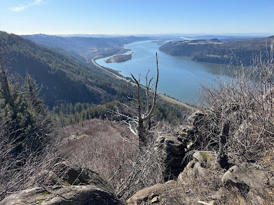
The approach to Angel's Rest is great: you see the outcrop and a few people enjoying the sunshine and views. I hiked to the loop and went clockwise. I stopped at a spot where I could take off my pack and have a few bites of my sandwich. I had plenty of daylight but I didn't want to push it since the next section of the hike was unknown to me.


I started toward Devil's Rest via some well-marked user trails: Foxglove Way trail to Red Shorts Cut to She Devil. It was a welcome sight to see the familiar destination.

As I continued back to the trailhead, I had a great view of Mt St Helens peaking out.


This photo was edited but when I finally got down to the Wahkeena switchbacks, the sun was going down and colors getting more orange and saturated.


It was a great way to spend the afternoon. I will definitely do this loop again. I loved the distance and EG, and you can hardly beat the views.

Sunday, February 4, 2024

Hike: Angel's Rest, Corbett, OR

Getting There

What an adventure! I set out from Portland without knowing where I was going to hike. I just knew I wanted to get outside for this rare, unseasonably warm weather. I've been wanting to get back to Wahkeena Falls #420 trail since the snow and ice storm in January.

When I reached the parking lot, it was windy and the Oregon side of the river was in shadow. Even though I'd just done Hamilton, the sunny side of the river (WA) looks so much more appealing. I blasted by the Multnomah Falls parking lot and continued onto Cascade Locks. I crossed the bridge and headed to Stevenson to get some snacks. 

On the way back, I decided against Hamilton and crossed the river again, another $3 and decided to go for the Wahkeena hike after all. I parked and suited up and was ready for the climb. The parking lot was nearly full so I didn't want to bother with the Multnomah Falls hike. I crossed under the freeway and headed to the traverse trail #442. Unfortunately, there was no way to reach the trail due to deep snow & ice. There was no way to walk along the road, too sketch.

Reluctantly, I walked back to the car and wondered if I was going to hike at all.

I decided on Angel's Rest. There's no exit from the westbound side of the I-84 so I had to go all the way to Rooster Rock and turn around. I backtracked to the Bridal Falls exit and found the main parking lot and overflow lot both full. Sad face! Frustrated, I headed south on Hwy 30 hoping for a last option, Latourell. Dammit. It was closed for repairs and maintenance.

I was dressed for a hike and had no where to go. It was getting late in the day for a long hike, ~2pm. I decided to give Angel's Rest another shot. There still wasn't any room in the main lot but I found one spot next to the road. I was weary of getting my car broken into.

The grabbed my pack and poles and started the hike.

The Hike

Length: 5.19 mi
Elev. gain: 1,490 ft
Moving time: 2:22:32
Avg pace: 27:29
Calories: 1,439
Total time: 2:44:23


It worked out in the end. The trail was in great shape. A little bit of mud and ice but otherwise, well groomed. 

I passed a bunch of hikers on the way down but it never felt crowded despite the number of cars in the lot. I was overdressed for the warm weather. I eventually stopped and stowed my outer shell jacket. The sunlight was gorgeous and golden. No snow except a couple of random patches deep in the bushes. If I'd been there sooner, I might have tried to get to Devil's Rest as well but will have to save that for another day.

On the way down, I noticed a hiker with a red MSHI patch. I said hello and introduced myself as a fellow volunteer. She recognized my name and said she'd sat next to me at the Volcano Naturalist class in Castle Rock. (Small world!)

In the end, it wasn't a particularly strenuous hike but I was glad to have gotten out there.


Saturday, June 26, 2021

Hike: Angel's Rest, Corbett, OR


AllTrails map

Getting There

I knew the temperatures this weekend in the Pacific Northwest were going to be crazy hot... like record setting. I was not to be deterred. I considered doing my Newton/BPA route again or wander around Sauvie Island.

I still needed to get some 32W shorts. I took a chance that REI in Hillsboro would have what I needed. I'd checked out Dick's looking for the poles that came with all the feet. None of them had any; spikes and/or or baskets. They must be totally sold out.

I still did not find poles but I really don't need them, just the feet. They had the 'boots'! They cost as much as I paid for the poles but oh well. They had some shorts as well.

Back in Portland, opted at the last minute to skip Newton Rd and started out Hwy 30. I passed up Sauvie as well. I did a u-turn and started out toward Troutdale.

I got the the Bridal Veil Falls exit and got a view of the parking lot, I was kind of shocked that it was nearly empty. Whoa. On a Saturday? It wasn't that hot. I think 103.

I geared up and set out. I had plenty of water!


The Hike

Length: 4.5 miles
Elevation Gain: 1,476 feet
Type: Up and Back


This is my 2nd recent hike (Spring '21) but I'm sure I'd hiked it years ago.

I passed by two couples early on the trail. They didn't look like they were in for the long haul. 16oz of water for both of them.

A couple of people came down the trail early on as well.

It certainly was hot but it wasn't as bad as I anticipated. The shade really helped a lot. I really noticed the temperature difference when I had to hike in direct sunlight.

The last 3rd of the hike is pretty much out in the open. There were some large trees or bushes to get a little shade.

I found a little bit of shade between two big rocks. I had my foam pad so it was cushy on the tushy.

They was so restorative. I cooled down enough to explore the rest of the outlook.

It was bizarre to be completely alone. Last weekend, there were so many cars, even the overflow lot.

View from my little spot out of the sun


It was pretty hot out.

A look at Archer Mountain, Phlox Point, & Hamilton Mountain

Looking west up the Columbia River

Thoughts:

I'd like to come back and hike up to Devil's Rest.
Or, park on Larch Mtn Road and hike down to here.

Wednesday, June 2, 2021

Hike: Angel's Rest, Corbett, OR


Length: 4.5 miles
Elevation Gain: 1,476 feet
Type: Out & Back
Steps: ~11,000


Getting There

After what was likely a super busy Memorial Day weekend in the Columbia Gorge, I ventured out I-84 for a midweek hike. It was still busy on the old highway and even a shuttle service for some of the waterfalls. I'd already set my sights on Angel's Rest when I was home so that was my original plan.

Fortunately, there were a couple of spots at the main parking lot. I geared up and got going.


The Hike

The trail stays in the trees for a while. There is one or two scree fields that were easily negotiated with hiking poles to help. There is a spot to dip your toes in the water about 1/3rd of the way up.

The trail opens up under taller trees in a series of switchbacks. You can start to see blue sky and glimpses of the river.

After 6 or 7 switchbacks you lose the forest canopy and are hiking in the sun (or rain or clouds). The 180 views are starting to improve as you gain elevation.

Near the top, there's another scree field to cross before Angel's Rest.

I stopped to take in the scene and have a sandwich. Not too crowded. There were some squirrels and some colorful birds with long beaks looking for a snack.

It was great to see my recent hiking spots on the WA side from the OR side: Cape Horn and Hamilton Mountain.

I never saw the turn for Devils Rest.