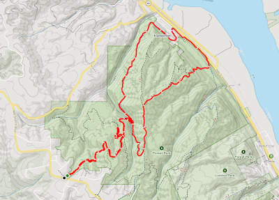
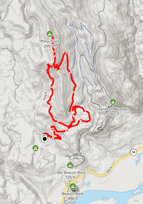
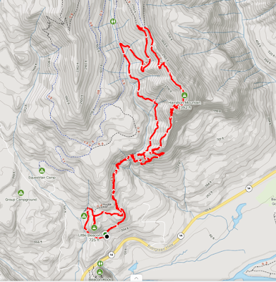
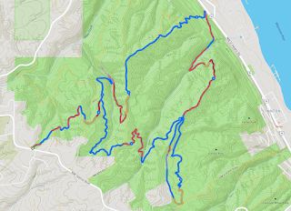
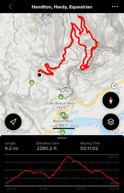
Friday, November 26, 2021

Hike: Hamilton Mountain & Hardy Creek, N Bonneville, WA


AllTrails map

Getting There


When I checked the forecast for Skamania it said overcast until around 7 pm but driving through Washougal and into the Gorge it was raining and drizzle. 

I was surprised to find the Hamilton Mountain trailhead was full. I waited for a few minutes to see if any cars might leave but I didn’t see anyone coming off the trail.

I wasn’t sure I wanted to do Phlox Point again but I knew the Equestrian Trail parking would have room. In fact there were just two other cars.

The Hike


Distance: 9.19 miles 
Elevation Gain: 2,280.2 ft
Moving Time: 03:11:02

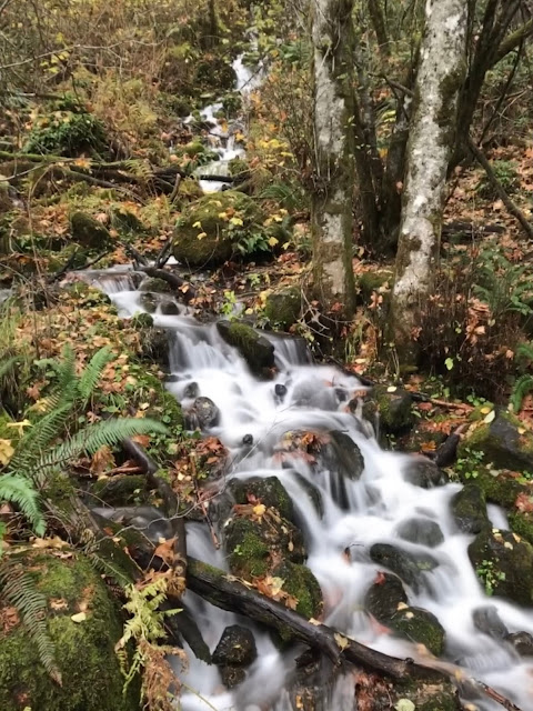
I was misty and wet but I was projected from the rain but the forest canopy. I saw one couple with a dog but never saw the person/people from the other car.

I noticed fresh tracks from a vehicle in the mud and it turned out to be a park ranger. I waved when they drove passed.

I still wasn’t sure which route I was going to do. I briefly considered a clockwise loop, hitting the Saddle and then Hamilton. When I got to the Hardy Creek trail I even started up the next section but turned around.

I wanted that climb that only the counterclockwise loop gives. I saw another two hikers and their dogs at the Hardy Creek junction.

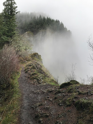
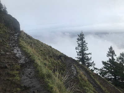
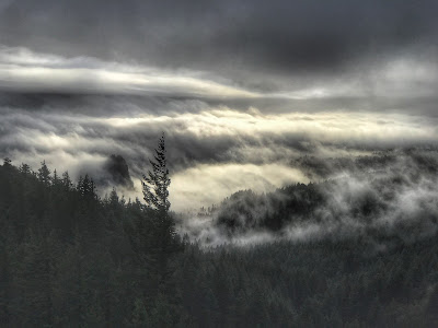
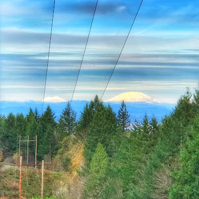
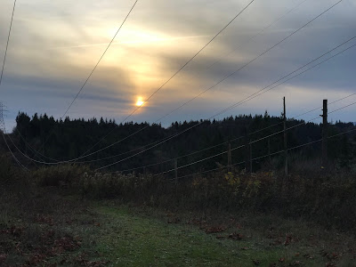
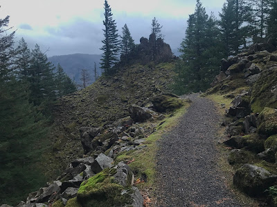
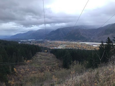
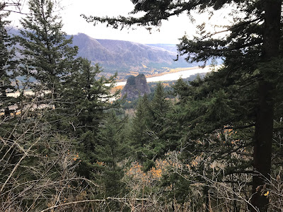
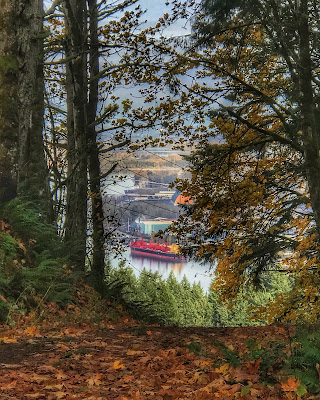
When I reached the switchbacks the views were incredible. The fog filled the Gorge and the sun was piercing through the upper clouds.

I was running out of daylight when I reached the Saddle. It was a long 4.0 mi descent on the Equestrian Trail. I kept a brisk pace.


Tuesday, November 23, 2021

Hike: Forest Park (Firelane 12, 15, BPA Road) XI, Portland, OR

AllTrails map

Getting There

Take NW Skyline Blvd north from NW Germantown Road. The Skyline Blvd Trailhead is 1.6 mi and a parking are available on right (east) side of the road.

I parked, geared up and set out.


The Hike

Distance: 6.96 mi
Elevation Gain: 1,650 ft
Moving Time: 2:16:41
Total Time: 2:21:01
Avg Pace: 19:39
Calories: 1,204
Type: Loop (except section to trailhead)

This is the 11th time I've hiked this section of the park but I tried a new route this time.

I did the first segment to the Firelane 12-15-Wildwood and I took Firelane 12 all the way down to Hwy 30. Actually, the trail ends in the neighborhood of Harborton (NW Creston Road & NW Harborton Drive.)

Then, I traversed along Hwy 30 (noisy) but I saw some interesting trash like love notes on heart-shaped sheets, like torn for a teenager's notebook.

I considered going up Newton Road but opted to just take the BPA Road up. Using my hiking poles seemed to help, I didn't feel as winded as without. The tiny push I got from each arm helped enough to make a difference.

I stopped for a couple of minutes to talk to a woman with a dog. My time was slower than usual. 3:17-3:46 = 29 min vs the usual 25. Maybe those couple of minutes chatting but I really feel like the poles helped me go faster. Guess not.

I wanted to check out Wildwood to Newberry but it was pretty muddy/mucky out there and I bailed after 0.2mi (0.4mi rt).

I didn't start my hike until about 2:10p so I had limited daylight. It was dark when I reach the St John's Bridge.


Saturday, November 20, 2021

Hike: Hardy Ridge Trail to Phlox Point, N Bonneville, WA


AllTrails map

Getting There

The trailhead is accessible from the Equestrian Camp Parking Lot, a bit west of Beacon Rock & Hamilton Mountain.

Take WA-14 from Vancouver, WA east toward N Bonneville. Just after Doetsch Ranch you'll see the Ranger Station on the north side of the road just before the Beacon Rock parking lot. The road winds up the hill for a bit. Keep a lookout for the the Equestrian Camp turn off.


The Hike

Distance: 9.93 mi
Elevation Gain: 2,415 ft
Moving Time: 3:27:59
Total Time: 3:35:46
Avg Pace: 20:57
Calories: 1,833

It turned out to be a great day for a hike. I visited a week or so before and it was really windy. Sat (11/20) it was in the 60s and pretty much windless.

Once you reach the bottom of the ridge where the Phlox Point out-n-back section of the trail starts, you're pretty much exposed to the elements, there is very little tree coverage. By comparison, the hike up to Hamilton Mtn is almost all in the trees.

The parking lot for Hamilton was full but there were many open spots in the Equestrian Trail parking lot.

I saw a dozen or so other hikers (in pairs mostly). I took the counter-clockwise route this time. It's a pretty steady incline for 3.2 mi (about 1400' foot elevation gain), some long switchbacks to the Phlox Point trail.

I made it all the way to the cairn pile at the top. On the way back to the trailhead, I took the Hardy Ridge trail back. The sun was golden at this point. The trail surface is perfect, cushioned with leaves and needles from the local evergreens & conifers.

I had a little energy left when I got back to the Equestrian Trail so I took a spin on the Loop Trail. It was pretty dark when I drove home at around 5pm.


Wednesday, November 17, 2021

Hike: Forest Park (Firelane 12, 15, Wildwood, Newton Road, BPA) X, Portland, OR

AllTrails map

Getting There

Take NW Skyline Blvd north from NW Germantown Road. The Skyline Blvd Trailhead is 1.6 mi and a parking are available on right (east) side of the road.

I parked, geared up and set out.


The Hike

Length: 8.69 miles
Elevation Gain: 2,014 feet
Type: Loop (except section to trailhead)

This is the 10th time I've done this general route and 4th time I've added a leg to Newton Rd Trailhead which adds about 1.6 miles but not much elevation change. 

I also added a few extra legs for extra elevation gain and distance. (I was <2200' to reach my 100K' goal). I hiked up to the high spot near the BPA Road Trailhead and another on Newton Road. (Net gain: +283' & +1.2mi).

It's still pretty muddy in spots but peaceful to hear the water flowing in the creeks. Just a smattering but always great to hear the little birds flitting about.

I even saw a small garter snake.

Ben's Bench on Wildwood Trail

View from the high point on the BPA Road.

Late afternoon in the Forest Park


Sunday, November 14, 2021

Hike: Hamilton Mountain & Hardy Creek Loop, N. Bonneville, WA

AllTrails

Getting There

Take WA-14 from Vancouver, WA east toward N Bonneville. Just after Doetsch Ranch you'll see the Ranger Station on the north side of the road just before the Beacon Rock parking lot, then another road across from the bathrooms. The road winds up the hill for a bit. 
 

The Hike

Distance: 8.46 mi
Elevation Gain: 2,339 ft
Moving Time: 3:13:49
Total Time: 3:21:00
Avg Pace: 22:55
Calories: 1,708

The weather in the Gorge was looking pretty stormy as I headed east. The woman in the car next to me said it was really windy up top, and she was right.

I made good time in the way up (3.0mi, 1h25m, 2,050ft). I kept expecting rain and thought I’d make it an up-and-back hike but at the top I said fuckit and started towards The Saddle. 

When I got out in the open the wind was really blowing. I took a selfie. 

I’ve only taken Don’s Cutoff once and today was not the day to try again. I was glad to be able to keep a brisk pace on the Equestrian Trail. 

When I reached the trail junction I thought ‘why don’t they have a trail between the Equestrian parking lot and Hamilton, Hadley Campground. Otherwise it’s a loooong walk on the road.

I was surprised to cross paths with a hiker going up. The sky was pretty dark and it was almost 4p. 

On a whim I took a spin out to Little Beacon. Such a rad view from there. 

It was a bit eerie walking through the empty campground back to the parking lot. There were still 2-3 cars besides mine. Glad to not be last to leave.


Friday, November 12, 2021

Gear: Hiking in the cold, wet seasons (vs. warm/hot, dry) in the Pacific Northwest

The Challenge

When I'm hiking, it doesn't take a lot of vigorous activity for me to work up a sweat. My old North Face backpack has been a trusty companion for 20 years, for both work and play, but it lacked a lot key features. After a busy summer on the trails, I realized it was time to upgrade. I purchased a new backpack by Osprey that has a mesh back and allows a lot of air flow between the pack and me. It also has a pocket for a 2-3 L bladder.

In the Spring and Summer when the weather is dry & warm, it's easy to manage perspiration by wearing quick-dry shirts and/or changing into a clean shirt for my descent. I have a couple of long sleeve shirts by KÜHL that are rated for UPF 50 and a quick drying.

Preikestolen, Rogaland, Norway

However, now that it's getting colder and wetter, it's a different ballgame. Perspiration could potentially be dangerous.

According the the CDC: "While hypothermia is most likely at very cold temperatures, it can occur even at cool temperatures (above 40°F) if a person becomes chilled from rain, sweat, or submersion in cold water." (source)

Search for winter hiking clothes

I've been looking for clothing (base layers, other) that will be appropriate for winter activities. I looked online and where I buy gear (REI, Dick's, Next Adventure) had options but just not quite what I wanted. Years ago, I found 32 Degrees base layers at Macy's. They tops are light fabric but provide a lot of warmth. I used then for just keeping warm in the city but also for skiing, snow boarding. I don't perspire nearly as much when skiing as I do while hiking. Plus, I'd have a thick ski jacket I wouldn't think of bringing on a hike.

Because I couldn't find thermals for winter, I just grabbed what I had to use in the meantime: my 32 Degrees Heat™tops.

Turns out they ARE moisture wicking and still retain body heat, even when damp.  

Black/White: 40% Polyester│34% Acrylic│22% Rayon│4% Spandex

☑︎ Lightweight for Easy Layering
☑︎ Retains Body Warmth
☑︎ Wicks Moisture
☑︎ Machine Washable
☑︎ Odor control

Link: https://www.32degrees.com/collections/heat


*I don't have any affiliation with 32 Degrees, I just like the gear.

Best materials for keeping you warm

(Source: #3 link in Related Articles)

Merino Wool

Pros: Natural material, versatile, it can be worn without washing for more than one day day.
Cons: Often expensive, very sensitive skins may find it a little rough

Silk

Pros: Natural material, super soft on the skin, not bulky
Cons: Expensive, requires frequent washing

Synthetic Fabrics

Pros: Cheap, easy to care for
Cons: Build odor quickly, need frequent washing

Wednesday, November 10, 2021

Hike: Forest Park (Firelane 12, 15, Wildwood, Newton Road, BPA) IX, Portland, OR

Footpath map

Getting There

Take NW Skyline Blvd north from NW Germantown Road. The Skyline Blvd Trailhead is 1.6 mi and a parking are available on right (east) side of the road.

I parked, geared up and set out.


The Hike

Length: 8.86 miles
Elevation Gain: 1,841 feet
Type: Loop (except section to trailhead)

This is the 9th time I've done this general route and 3rd time I've added a leg to Newton Rd Trailhead which adds about 1.6 miles but not much elevation change.

This time I did the clockwise direction, descending down BPA Road instead of ascending it.

It's amazing how a familiar trail is sudden "new" again by switch directions. I could kind of pick out some of the landmarks and usual "waypoints". 

I passed a hiker and their dog in the first couple of miles. I didn't see anyone until Kielhorn Meadow spur trail on the way back.

View from BPA Road

Note: My AllTrails app unexpectedly stopped recording my hike ಠ_ಠ so I have no record of actual distance, elevation +/-, total & moving times, calorie, avg pace.

So I'm going to try a new app/service called Footpath (footpathapp.com) which allow you to create hikes like multi-trail loops ahead of time. I was able to export the map as a GPX file and import it into AllTrails, however, it is imported as a Map and not an Activity, and no way to mark Completed. :(

I'm not willing to ditch AllTrails just yet but this is not the first time I've lost data because the app quit on me.