Showing posts with label Oneonta Gorge. Show all posts

Sunday, December 7, 2025

Hike: Oneonta Gorge via Horsetail Falls, Corbett, OR


Getting There

The hardest thing about hiking, especially in the winter months, is getting out of the house. I know I have about 3 weeks to try to squeeze in a few more hikes and up my stats. Like my previous hike reports, I got a later start so I had to pick somewhere close to home since it gets dark around 4:30p on the Oregon side of the Gorge.

I knew Ponytail Falls was short hike and while I like Oneonta Gorge, it doesn't offer views like some other Oregon Gorge hikes or most of them on the Washington side. I thought I would fit in TWO short hikes. I've been wanting to get back to Mitchell Point and the view point way above.

It was overcast but I saw it would only be partly cloudy in the late afternoon, slivers of blue sky and sunset colors. I only found a couple cars in the parking lot, and they weren't hiking per se. 

The Hike

Length: 6.88 mi
Elev. gain: 1,929 ft
Moving time: 3:16:17
Avg pace: 28:31
Calories: 1,729
Total time: 3:30:50 


I geared up and set out on my hike. Not far up the trail, I saw some folks I'd seen leaving the parking lot making their way up the switchbacks. The trail looked familiar from my last visit with TKO to build the rock wall.

Not far after that I met a girl seemingly on her way down dressed in leisureware. She flagged me down and asked me to take a photo for her. As usual, I'll take a couple of shots: landscape, portrait, slight adjustments to composition, zoom level (0.5x, 1.0x). I pulled up the last shot on her phone and offered to take more if she wanted. She took me up on the offer and changed her pose. I noticed the lens on the back of the phone had a smudge. I fumbled for something to clean it with. She offered the sleeve of her sweater. It was vaguely intimate as I gently held her wrist while I clean the camera lens. She was appreciative and asked where I was going and how far the upper waterfall was. I assured her it wasn't very far up the trail, <0.5 mile. She seemed reinvigorated to turn around and make the ascent. I wished her well and took off at a quicker pace.

I zoomed up the trail and passed the group I'd seen earlier. I crossed behind Ponytail Falls and continued on the trail towards Oneonta. I saw that group across the way but not the girl. I hope she made it.

I followed the trail west towards Oneonta Gorge. There was a viewpoint but already two people enjoying the scenery. I skipped it and kept going. I'd seen the route and switchbacks way down below from the other side so I knew what to expect. Somewhere along the way I decided to only hike here and not try to hit Mitchell Viewpoint. I would hike up to where we had lunch with TKO.

And, that's what I did. I kept plodding forward. Noting trees that were down over the trail but not taking GPS coordinates or photos. I'm sure TKO will be back in Spring to deal with them like we did last late winter.

I only saw two other hikers at Triple Falls and beyond. I felt comfortable but knew I'd never reach any end of the road or view, I would just timebox my hike: Reach that upper bridge by 3pm or turn back.


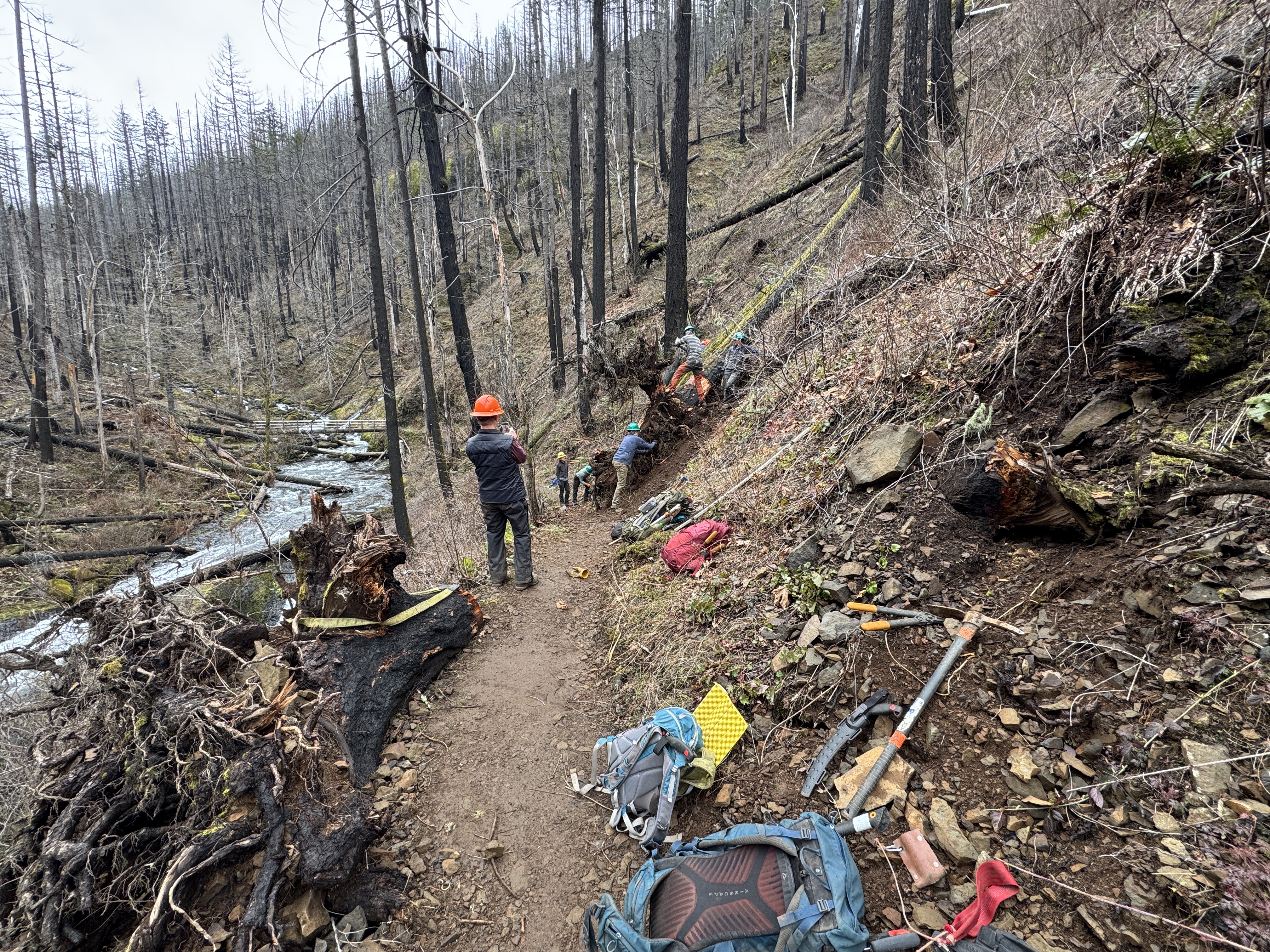
I stopped at Triple Falls to take my requisite photos and inspect the work we did last winter with TKO. I remember when we finally kicked the huge root ball over the side or the tree dropped on the edge of the trail as a border/reinforcement for erosion.

The descent requires a lot of attention to foot placement as there are tons of rock, slippery surfaces, and sketchy steep cliffs. It is mentally taxing. I breathed a sigh of relief when I started down to the bridge back to the east side of the gorge and on my way back to Ponytail Falls and my car.

I stopped at the viewpoint I'd skipped on my ascent. The skies were colorful as it was almost sunset.


By the time I reached Ponytail Falls, it was getting pretty dark. I wasn't worried because I was just a 0.25 mile from the trailhead and I could finish the hike without digging out my flashlight. I took a few photos of the waterfall. The long exposure made for some cool, ethereal shots.


The hike was almost done. I'd seen a photographer perched on the cliff side before I got to Ponytail, waiting for the perfect lighting. On a longer section of the lower switchbacks, I saw a couple with a dog on a leash. I thought I saw some recognition as we got closer to each other. One of them sat down on rock or stump. When I got about 6 ft away, I said "Good evening". The person sitting down gasped and I'd clearly scared them. I apologized and said I'd thought they'd stop to rest and let me pass. But they hadn't actually seen me. Oops. I repeated my apology and bounced down the trail.

Sure enough, I saw their car and photographer's car in the lot. I changed my shoes and into dry clothes. Not super long hike compared to recent outing to Angel's & Devil's Rest and Dog Mountain. I was glad to get one more hike under my belt.

Next hike will be on my birthday. I hope I don't get too tired from two work parties at Beacon Rock. 

Tuesday, March 11, 2025

Hike: Oneonta Falls, Cascade Locks, OR

Getting There

Since the Historic Highway 30 is closed between Wahkeena Falls and Multnomah Falls, you have to take I-84 to Ainsworth and double back to the Oneonta Falls Trailhead.

I was the first to arrive but the rest of the work crew showed up shortly thereafter. 

I left both water bottles at home. Fortunately, Oliver showed up and had extra. He gave me a full bottle of water. Thank goodness because I needed it.

We had the safety talk and geared up. 

The Hike

Distance: 3.52 miles
Elevation Gain: 765 feet
Highest Elevation: 650 feet


This was a trail work party with TKO but we did a decent hike so I added to the stats.

The original project plan was to replace the gabions on one of the switchbacks but scrapped due to unfavorable weather forecast. So they would be stolen at the trailhead, we carried the the gabion cages up to the #400 Gorge Trail junction.

I carried a grub hoe and snatch block. We were going to be fixing the tread along the way but the main goal was to clear some trees and root balls near Triple Falls.

At our first big task, we had to bring down a tree that was suspended over the trail. While evaluating the cut plan, I started limbing the trunk as far up as I could reach. I felt fine but out of the blue, I got really woozy. I had to sit on a rock and let it pass over me. I didn't want to alarm the new orange hats. After 10 mins, I finally felt good enough to start moving again.

I went back to my pack and ate one part of my sandwich and drank some water. I didn't want to be the "new" guy that needed help. Note to self: make sure you hydrate and eat sufficiently before a strenuous hike & work party.

We cut down the log but it didn't roll off the trail. We used the old "butts & boots" method to got it off the tread. Basically, you sit on the ground or hillside (on yer butts) and collectively push the log (roll it) with your boots. There wasn't much tread repair so we wrapped it the task. The rest of the team was already having lunch at Triple Falls.

We met them and started out lunch while reviewing the next task.

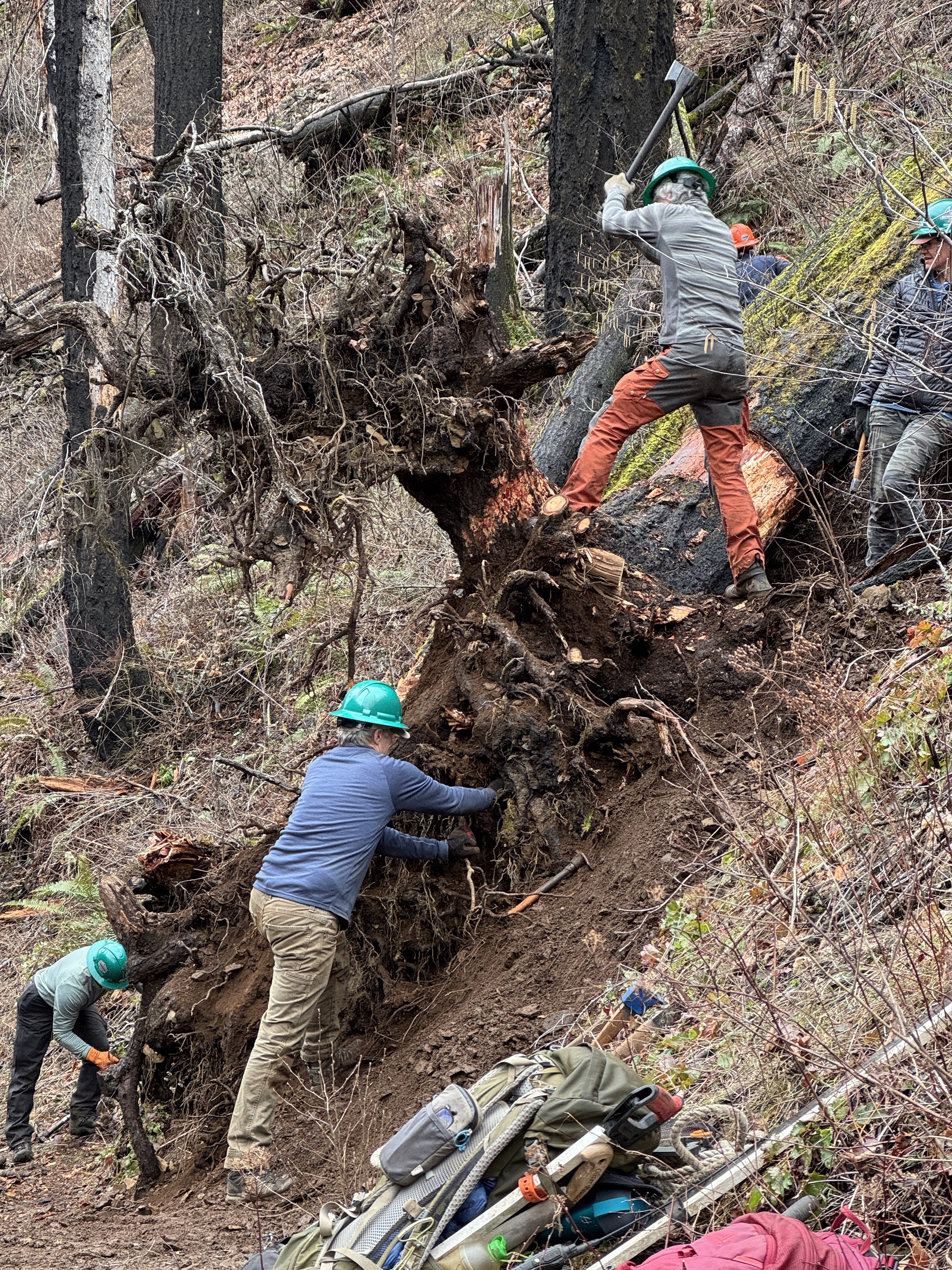
It was a bit of a complex situation. There was a big root ball right off the trail. The goal was to cut it off and roll it off the hill. There were some other trees that it was rest on, a bind. We spent a lot of time preparing the root ball by removing dirt and rocks to expose the wood (roots).

We had two crosscut saws working in parallel and some long-bladed hand saws.

A hiker showed up but had to wait while we B&B'd a log off the trail. When the coast was clear, I learned he was just hanging out to watch us work, fascinated by the process.

The main root ball turned out to be a tough task than expected. We used a rope and winch to pull the cut pieces but it was quite stubborn. After cutting the root ball off the trunk and pull it upright with winch it landed in the middle of the trail instead of tumbling over the side of the cliff. Crap!

It was getting later in the day and we still had to hike back down to the trailhead. We could leave it as-is.

We identified some roots that could be cut to make the ball actually roll. We took turns on the saw as folks' energy was waning.

Triumphantly, we got the job done. The piece fell into the ravine and we quickly repaired the tread. Woohoo! Teamwork.

We packed up and started our descent.


Saturday, August 12, 2023

Hike: Oneonta Gorge Trail, Cascade Locks, OR

Getting There

Take the Historic Columbia River Highway (Hwy 30), constructed between 1913 and 1922. The Oneonta Trailhead is 2.0 miles east of Multnomah Falls, and just 0.6 miles west of Horsetail Falls Trailhead.

You can access Hwy 30 via I-84 via Exit 28 (Bridal Veil/Angel's Rest) or Exit 35 (Ainsworth State Park) from either the west or eastbound lanes. 

In the morning to just after lunch, I was volunteering at Latourell Falls as a Trail Ambassador for Trailkeepers of Oregon (TKO), greeting visitors, orienting them about the trail, and suggesting other waterfall hikes.

Since I was in the area and already had my hiking boots on, I figured I could get in a hike and log some miles for WTA's 2023 Hike-a-Thon. Originally, I'd planned to hike up Wahkeena Falls since I hadn't been there since winter. I knew the trailheads were going to be busy but I was hoping for an open spot. Unfortunately, Wahkeena's main and auxiliary parking lots were full. I was running low on gas, so my closest places for fuel was Cascade Locks so I continued on Hwy 30 in that direction. 

When I reached Oneonta & Horsetails Falls Trailheads, there was ample parking. I pulled into a spot and headed out.

The Hike

Length: 4.55 mi
Elev. gain: 1,375 ft
Moving time: 2:03:36
Avg pace: 27:09
Calories: 270
Total time: 2:12:02


The first part of the trail is a long switchback in the trees and gradual climb. Once you reach the gorge, it starts to climb a bit. There's a permit box at the junction for Horsetail Falls Trail. It looks like a steep descent down but I was headed for Triple Falls and beyond.


The forest is gone. The trees were burnt in the 2017 fire which started at Eagle Creek. There is no shade except behind a few large tree trunks. The trail is stable but there are a few spots where careful footing is wise as the drops are pretty sheer. 

There are some viewpoints of the gorge.


I finally made it to a viewpoint for Triple Falls. I can imagine this surrounded by a lush forest but now it's a stark reminder of the fire 6 years ago. I continued up to the bridge. There was a group of hikers sitting next to the creek, cooling off in the shade. It was pretty hot and I was feeling it. Probably in the high 80s to low 90s.


I had another 1.5 liters of water but low on electrolytes. I wasn't sure what lie ahead on the trail but continued up. I found a spot to get down to the water. Not to fill up my bottles because I didn't bring a filter but to dunk my neck gaiter to help cool down.

There was a couple going in the same direction. They passed me but I passed them a bit later when they were stopped in the little shade there was. I was started to get chills; not good; it's a sign my body is having trouble regulating the temperature. I didn't have a clear destination and I didn't want to take any chances so I turned around and started the walk back to Triple Falls.

Even when going downhill, I continued to have the occasional wave of chills. I drank more water and took my time. When I reached the bridge I stopped to take a panorama and rest in the shade. I was starting to feel better and enjoyed the descent down the gorge.

Further down the trail, I came across a pair of hikers that looked a bit exhausted and were sitting on the trail. One of them asked me about Horsetail Falls Trail but I said I thought it was down below at the Mark O. Hatfield Wilderness permit box. They said they hoping to reach Triple Falls. I gave wrong info as I thought it meant the series of Oneonta Falls (Lower, Middle, and Upper) but in fact, the bridge WAS Triple Falls. Oops.

I stubbed my right big toe even though the Keens have a burly rubber toe cap. It slowed me down a bit as my toes were snug against the front of the boot on the downhill.

I made it back to the trailhead/parking lot and continued east to Cascade Locks to get some gas. I noticed quite a few thru hikers walking around town. Oregon now has self-serve fuel. Kinda of a trip. I remember when I first moved to the state 20 years ago, I'd absentmindedly got out of my truck and got reprimanded for starting to pump my own gas.

I thought about stopping for a late lunch at the Bridgeside but zoomed by and got back on the freeway.

I still had to drop off my TKO stuff at Rooster Rock. When I'd been there in the morning, the ranger station was closed but this time a person was checking & selling parking permits. I told them I was with TKO and there to drop off my stuff, and the ranger waved me through.

All in all, a good day in the Gorge.