What a great way to wrap up the year! I surpassed all my hiking goals:
75 hikes, 500 miles, 120,000 feet
Note: These figures are my baseline for next year. I didn't regularly start recording my hikes on the AllTrails mobile app until April, instead using the mileage + elevation gain from curated AllTrails maps.
Why 75 hikes?
Originally the goal was 100 hikes but I soon realized it was a bit out of reach at the time, starting in earnest mid-summer. Over a calendar year, it's one hike every 3.65 days, twice a week, rain, shine or otherwise. I've seen other hiking challenges online like the 52-Hike Challenge that is based on 1 hike per week. 75 hikes is still basically once per week, plus a couple of midweek hikes per month (total 6). It definitely takes some commitment to the cause but it's also been a good motivator for maintaining proper fitness and nutrition.
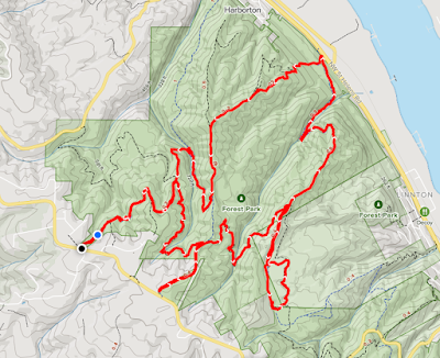
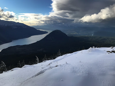
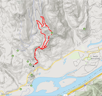
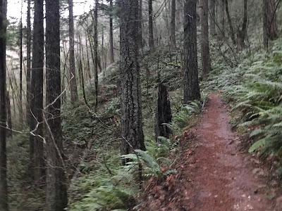
After my road trip in 2019 where I spent virtually all my time in the car, I vowed to "travel less and hike more". Easier said than done. It was a challenge to find suitable hikes that offered decent mileage and elevation that are under an hour's drive. I found a section of Forest Park that fit the bill. I also became a regular on the Hamilton Mountain Trail.
To prepare for my Mt St Helens summit hike, I created a great loop in
Forest Park that's about 8 miles and up to 2,000 ft of elevation gain.
It's close to home and good for an afternoon escape. This year I've hiked Forest Park 18 times and Hamilton Mountain 15 times.
Another way I got to 75+ hikes was by completing multiple ascents on the same day on different trails. I purposefully did not count walks and other types of exercise. Required: Hiking boots, poles, dirt (or snow) under foot! I thought about
only counting new hikes/trails but thought that would really limit my options and I wanted credit for the practice hikes. It might be an interesting metric to track next year.
Why 500 miles?
No, I wasn't inspired by the lyrics of that catchy but annoying song by The Proclaimers. This is just a somewhat arbitrary, round number. At 75 hikes, this works out to the spooky decimal of 6.66 miles (average) per hike. Totally doable because I'm usually clocking in 7-8 miles per hike and could take some shorter hikes without falling behind on miles.
When I was coming up with the goal mid-year. I looked at the remaining months and how feasible it would be to reach. Plus, I just liked the look of 500. I may move the bar to 600 miles for 2022.
What destinations are 500 miles from Portland?
San Francisco, CA is 500 miles from Portland, and so is Banff & Bubblegum in British Columbia. It's about the same as a round trip to Bellingham, WA (at least by highway).
Elsewhere in the US, for example, it's roughly 500 miles from New Orleans to Dallas.
And in Europe, according to MatadorNetwork, "If you walk 500 miles from Vienna, you could visit 30 different countries."
Why 120,000 ft?
Well, until the end of November, this goal was set a 100,000 ft because it was feasible and it was another nice looking number with lots of zeros. When I realized I was going to safely surpass 100k feet, I revised the goal to 120k feet as it would give me the most accurate baseline for next year.
At 75 hikes, this works about to 1,600 feet of elevation gain per hike. Again, totally doable as my Forest Hike practice loop is between 1700-2000 ft. I could take some hikes with less elevation gain and not fall behind.
What is it like at 120,000 feet high (23 mi/37 km)?
The photo of Felix Baumgartner in the doorway of the Red Bull Stratos pod getting ready for his jump really puts it into perspective. Also, the photo from World View's balloon is a striking way to illustrate the height.
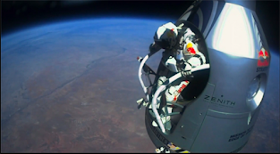 |
| Credit: Red Bull Stratos |
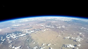 |
| Credit: World View |
Fitbit uses some interesting comparisons/achievements.
These stats are incomplete because I didn't always hike with my Fitbit and the mileage is calculated from Steps times Average Stride Length rather than the Actual Distance moved via GPS. When hiking up inclines and technical section you tend to take smaller steps so the mileage is often inflated.
Also, the way the Floors is calculated makes it an inaccurate analog to elevation gain. According to SteveH on the Fitbit blog, Floor are based on 10 ft (3m) of continuous rise. "So, if you rise 9 feet, level off for a few steps, then rise another 9 feet then you rise 18 feet but get zero floors."
Yearly Totals:
1,808,672 steps ● 13817 floors ● 825.33 miles ● 781,454 calories
And, one caveat about the following information is that all lesser levels are incremented when a Trail Badge is earned, e.g. when you hike 16k daily steps, you earn the Urban Boot, Sneakers, Boat Shoe badges.
Daily Steps- Hiking Boot: 35,000 steps in a day (1x) |
Daily Climbs- Canyon: 400 floors in a day
(1x) |
Lifetime Distance- New Zealand: 990 lifetime miles
(1x) |
Lifetime Climb- Spaceship: 14,000 lifetime floors
(1x) |
Reflections
It's mind-boggling what I accomplished with my own two feet (and legs), motivation, perseverance, determination.
Before I started my arthritis diagnosis & treatment in 2019, I was having all kinds of problems with my knees. After 2 or 3 months of 1-on-1s with a trainer, I started the treatment. I spent the first couple of months binging GOT and other shows because it took this long to get the symptoms under control. I was resigned to having limited mobility and losing my independence. It was real low point but thankfully the pain subsided when the meds began to work, and I'd changed my diet, quit smoking & drinking, cold turkey, and started my regiment of supplements like fish oil, turmeric, and bromelain. I did zero hikes in 2019 but I completed to a programming bootcamp and started building my web development portfolio.
When I hiked the Hummocks Trail in March 2020, I didn't realize it would be the start of the pandemic but also my renewed love of hiking. Not quite. I didn't hit the trail again until July after a lot of scouting on Lolo Pass Road and a hike up Vista Ridge. A couple weeks later I tackled Kendall Katwalk at 12 miles round trip and Crater Lakes at 8.6 miles. After than, I began to pick up steam.
My first hike to the bottom of Little Hamilton was just 10 1/2 month ago! I had no idea at the time, it would become one of my favorite hikes. When I finally reached the summit in April, I was unfamiliar with the rest of the park and the Saddle and gave some fellow hikers bad info. I was determined to learn as much as I could and be an expert about the place, a steward. I never want that to happen again.
This accomplishment is a bit of a middle finger at RA and my diagnosis. Hiking has been a much needed way to do more than just cope with the pandemic, my health issues, my job issues, to actually improve my physical and & mental health and focus on externals and see the beauty around me. And, take some amazing photos.
I participated in a couple of challenges this year:
"46Climbs was built off of our passion for the outdoors, and the therapeutic benefits received from the physical challenges that only climbing, hiking and running can bring."
and WTA's Hike-A-Thon.
"Get Out. Give Back. Hike-a-Thon gives you the opportunity to support the trails you love while you hike. Each August, participants spend the month hiking and sharing their outdoor adventures to promote the power of trails and raise funds for WTA! We look forward to celebrating the 19th Annual Hike-a-Thon with you in 2022."
This achievement is very personal but it has a quality of indelibility that some of my other pursuits do not. If the RA disables me in the future, at least I will have the memories from this time. The same goes for my financial situation; better to have memories than save for a tomorrow that never comes, or one where I'm not physically able to hike.
"Look at the people who live to retire; to put those savings away. And then when they’re 65 they don’t have any energy left. They’re more or less impotent. And they go and rot in some, old peoples, senior citizens community. Because we simply cheated ourselves the whole way down the line."
I've spent a lot of time thinking "I'll have time later". On the trip in 2019, I was imaging coming back with friends, family at some date in the future; a scouting trip. Rather than actually having the experiences, I was kind of viewing them through my car's windows and in 3D for the occasional photo op or potty break.
"In a car you're always in a compartment, and because you're used to it you don't realize that through that car window everything you see is just more TV. You're a passive observer and it is all moving by you boringly in a frame.
On a cycle the frame is gone. You're completely in contact with it all. You're in the scene, not just watching it anymore, and the sense of presence is overwhelming."
Fred "Dirtbag" Beckey is someone that exemplifies doing what you love until the very end. It is sad to realize you no longer have the energy to complete the task, the trek but you shouldn't give up before your time.
Checkout the documentary "Dirtbag: The Legend of Fred Beckey".
"Fred Beckey is the original American "Dirtbag" mountaineer. The groundbreaking life story of this rebel athlete, who inspired generations of climbers with his monumental first ascents and eloquent books, is told for the first time in this exclusive documentary film."
Evolution of my Road Tripping
2019 Road Trip
After finishing my programming class in the summer of 2019, I needed to get away for some R & R. I took a road trip out east, OR, WA, ID, MT. I didn't have a set itinerary but keep going east with my inflection point being Whitefish, MT. I spent 7 days driving almost 2000 miles. This didn't give me much time to get out and smell the wildflowers or get some dirt under foot.
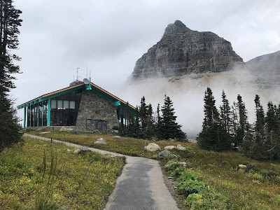 |
| Logan Pass, Glacier NP, MT |
I spent a day driving to Glacier National Park and barely go out to stretch my legs before hopping in the car to drive back to Whitefish. I have no real regrets from this trip but I can't always treat trips as scouting trips. Carpe Diem!
2020 Road Trip
When I was planning my 2020 summer trip, I decided to stay much closer to home and routed a trip up the middle of WA, routing through Mt Rainier, Snoqualmie Pass, Lake Chelan, and the North Cascades Scenic Byway, Mountain Loop Highway.
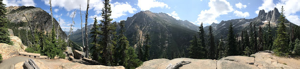 |
| Liberty Bell Mountain (far right) and Kangaroo Ridge, North Cascades, WA |
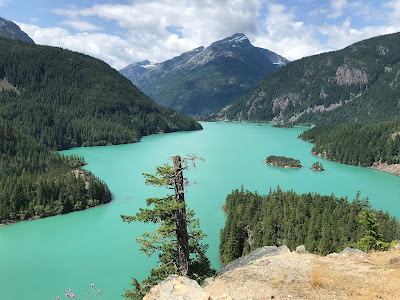 |
| Ross Lake, North Cascades, WA |
I built several days of hiking into my itinerary including two nights in Snoqualmie Pass to hike Kendall Katwalk and two nights at Lake Chelan to hike Crater Lakes/Methow. On my drive on the byway toward Concrete, I stopped at Diablo Lake to hike.
Nevertheless, I still spent four days in the car.
2021 Road Trip

So, for my 2021 summer trip, I planned an even shorter road trip and hiking every day. I camped near MSH and did a hike from Windy Ridge. Then, I stayed two nights in Packwood and hiked Mt Rainier, and two nights in Snoqualmie Pass and hiked Kendall Katwalk, Kachess Lake and, Gold Creek.
Because I hadn't made reservations for my southbound trip, I ended up sleeping in my car on the forest road near High Rock Lookout. The last day of the trip, I took an amazing 2nd hike up around Panorama Point and reached nearly 7500' on the Muir Camp Trail.
Besides the Sunday drive to Iron Creek campground, I hiked every day thereafter.
What an adventure; this trip included 7 different hikes:
- Total Distance: 52.17 miles
- Total Elevation Gain: 11,770 feet
- Highest Elevation: 7,441 feet (Mt Rainer)
- Most Elevation: 2,943 feet (Kendall Katwalk)
- Longest Distance: 13.1 miles (Kendall Katwalk)
- Avg. Distance: 7.45 miles
- Avg. Elevation Gain: 1,681 feet
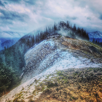
Mt St Helens Summit
I reached several peaks this year but MSH topped the list. I hiked Hamilton Mountain (2060'), Silver Star Mountain (2096'), Archer Mountain (2444'), Phlox Point (2231'), Coldwater Peak (3980'), Plummer Peak (6370') but my crowning achievement was summiting ...
Mt St Helens (8278')
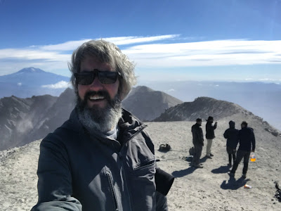 |
| Summit selfie, MSH |
Backstory
In 2020, when I was out exploring the four lakes (Merrill, Swift, Yale, Merwin), I ended up at the Climber's Bivouac trailhead in the mid-afternoon. I went for a scouting hike and realized it was the trail to the top! I didn't have a permit and wasn't physically prepared and was under-dressed.
I got a permit for mid Oct but ended up forfeiting it due to weather or something else, I can't recall. I knew the 100/day limit only ran until Oct 31st. The weather was looking good for Nov 1st so I planned my attempt for that day instead. I left Portland around 5:30am and got to the forest road 1800 around 7:30am. There were cars parked on the shoulder like a 1/4 mile from the parking lot I'd been a few weeks earlier. Holy cow! I was not ready for that and since it was still the pandemic, I didn't want to be amongst so many people. I ended up having an amazing hike on Ape Canyon trail to Pumice Butte.
I filed the idea in the back of my mind. "I will conquer this beautiful mountain in 2021!"
The way the permits were distributed changed in 2021. The permits for each month were released the month before; to hike in Sept, I had to get my permit on Aug 1st. I figured there would be less snow to contend with but I was kind of intrigued by the trail reports about glissading from the summit. I even bought a climbing pick and watched a couple of videos on how to carry and self-arrest from various body orientations (headfirst, feet-first, on back, on stomach).
By Labor Day, I was getting pretty psyched. I'd had a great summer of hiking and felt physically ready. I also gave myself an 'out' by saying just showing up on 1/2 the battle, and even if I don't reach the top, my hike was already a success.
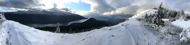
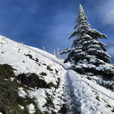
Sept 15, 2021 - Hike to the Summit
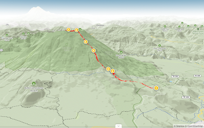 |
| AllTrails map, MSH Summit vs Ptarmigan Trail |
It was largely a mental game. I was fit for the challenge but each steps seemed to result in another ridge to get over, it seemed endless. (I passed a guy climbing through the boulders that seemed a bit defeated already. "How much more of the 'rocks'?" he asked, somewhat exasperated. I said something like "Not too much more (trying to sound encouraging)." I really had no idea.) I remember seeing another hiker that that had broken down in tears. I knew how it felt to slog through the rock section then encounter this long ash field. Traction was pretty good, esp. with poles, but you lose one step for every 5 taken. I'm sure the terrain is constantly changing.
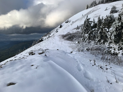
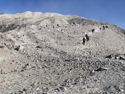 |
| The final stretch of the Ptarmigan Trail, MSH |
I remember Bear Grylls talking about breaking difficult tasks into smaller pieces. When he was climbing across a deep ravine on a rope, he was counting to "20" and taking a rest. By the ash section about a dozen hikers had queued up. I ended up at the back of the group. I was someone motivating to try to keep pace with those in front of me. I also noticed the two brother (who I met later), that took a lot of breaks. I matched mine to theirs.
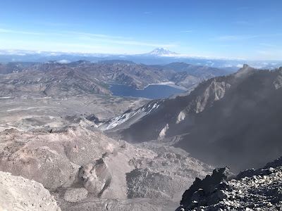 |
| View from the rim: Spirit Lake & Mt Rainier in distance |
That feeling taking those last few steps and seeing Spirit Lake and crater was just incredible. I really had done it! I wasn't finished yet. The "true" summit was calling to me. The guys I'd met lower down and a solo hiker lead the way. It was pretty challenging to climb down the rocks and up the other side. I'd just hiked for 4 hrs straight and I was running on adrenaline.
I spent an hour up there and 3 hours on my descent. Pretty much 8 hrs round trip. While I was just one of dozens that reached the top, I was joining a select few. I only know one other person that's made it.
What's next?
 |
| AllTrails :: Mt Adams South Climb Trail |
I've got my eye on Mt Adams for 2022! I recently joined the PNW Peakbaggers Facebook group in order to connect with others for information and collaboration. During a chat with a fellow hiker, the South Route is mostly a long walk uphill, no crossing glaciers or crevices.
Mt Baker is considered another good "beginner" peak but it has some additional technical elements like rocks and glaciers that Mt Adams does not. Both climbs are considered good "stepping stones" before climbing Mt Rainier.
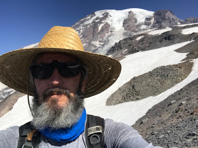 |
| Mt Rainier: Elevation 7,441 feet |
When I hiked above Panorama Point from Paradise Lodge this summer, I knew I want to come back and climb to the Muir Camp. I'm not sure I'm seasoned enough yet to attempt the summit but getting to the 10,000 ft point would be a great achievement.
For now, I'm looking forward to observing Mt St Helens, Mt Hood, and Mt Rainier from the top of Mt Adams!
Overall Stats for the Year
- Number of Hikes: 77
- Total Distance: 516 miles
- Total Elevation Gain: 122,121 feet
- Average Distance per Hike: 6.70 miles
- Average Elevation Gain per Hike: 1,586 feet
- Longest Hike: 15.40 miles (Ape Canyon/Windy Pass, 7/10/2021)
- Highest Elevation in a Hike: 8,278 feet (Mt St Helens, 9/15/2021)
- Most Elevation in a Hike: 4,583 feet (Mt St Helens, 9/15/2021)
Check out these platforms for updates and photos


Photo Credits
2. Red Bull Stratos, https://www.smithsonianmag.com/smart-news/three-views-of-felix-baumgartners-record-breaking-skydive-from-the-stratosphere-72988008/
3. World View, https://www.space.com/26531-world-view-balloon-test-flight-video.html
"This image released by World View on June 23, 2014, offers a glimpse of the view the company's 'Voyagers' will be treated to during flights to 120,000 feet. On June 18, Arizona-based World View launched a scaled-down version of its balloon system to an altitude of nearly 23 miles (37 kilometers) during a test flight that originated in New Mexico. The new World View balloon video of that unmanned flight, which the company shared with Space.com today (July 15), reveals some spectacular views of Earth from the stratosphere."
4. Larry Moiola, Logan Pass, Glacier NP, 2019
5. Larry Moiola, WA Pass, N Cascades Byway, 2020
6. Larry Moiola, Ross Lake, WA, 2021
7. Larry Moiola, Mt Rainier, 2021
8. Larry Moiola, selfie, 2021
9. AllTrails 3D Maps, https://www.alltrails.com/explore/trail/us/washington/mount-saint-helens-summit-via-ptarmigan-trail
10. Larry Moiola, final stretch, 2021
11. Larry Moiola, view from the rim, 2021
12. AllTrails 3D Maps, https://www.alltrails.com/explore/trail/us/washington/mount-adams-south-climb-trail
13. Larry Moiola, selfie, 2021