Showing posts with label Hardy Ridge. Show all posts

Saturday, May 24, 2025

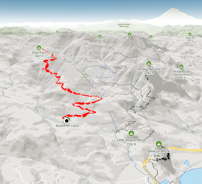
Hike: Phlox Point via West Hardy Ridge, N Bonneville, WA

Getting There

The trailhead is accessible from the Equestrian Camp Parking Lot, a bit west of Beacon Rock & Hamilton Mountain.

Take WA-14 from Vancouver, WA east toward N Bonneville. Just after Doetsch Ranch you'll see the Ranger Station on the north side of the road just before the Beacon Rock parking lot. The road winds up the hill for a bit. Keep a lookout for the the Equestrian Camp turn off.

It was a warmer than average day and a holiday weekend, so I knew most, if not all, Gorge (WA, OR). trailheads were going have a lot of people. I left before noon but still a late-ish start. When I reached Beacon Rock, cars were parked all along the road and there was a sign saying "Hamilton Mountain parking lot FULL". In the past, I've often found a spot despite the warning but this time, I decided to check the Equestrian Trail parking lot. Bingo, there were lots of cars but no where near full. Woohoo!

The Hike

Length: 8.52 mi
Elev. gain: 2,195 ft
Moving time: 3:40:17
Avg pace: 25:52
Calories: 1,941
Total time: 4:09:42


This was my first recreational hike since March. In April and May, I was doing trail work parties with WTA and TKO, but I was also sidelined with vertigo (again!). No fun.

I wanted a familiar trail or location to check my fitness level. 

I felt strong all the way up and was planning where I would go after I made it to Phlox Point. In fact, I didn't know I was even hiking up to Phlox Point until I reached the junction. I thought about a bunch of other options including hitting The Saddle and Hamilton Mountain. Last time I did this it in 2023, the hike was over 14 miles and about 3600 feet of elevation gain. 

On my way back to the junction with the Hardy Ridge trail, my feet were barking and I saw it was later than I thought. I might have at least hiked up to The Saddle via the Bridge trail and Don's Cutoff but not today.

I had some good conversations with a couple of hikers I encountered. It was a good day!


Sunday, March 26, 2023

Hike: Hardy Ridge + Hamilton Saddle, N Bonneville, WA


Getting There

The trailhead is accessible from the Equestrian Camp Parking Lot, a bit west of Beacon Rock & Hamilton Mountain.

Take WA-14 from Vancouver, WA east toward N Bonneville. Just after Doetsch Ranch you'll see the Ranger Station on the north side of the road just before the Beacon Rock parking lot. The road winds up the hill for a bit. Keep a lookout for the the Equestrian Camp turn off.

The Hike

Distance: 10.15 miles
Total Elevation: 2,570 feet
Highest Elevation: 2,568 feet
Time: about 4 hours
Steps (Apple Health app): 21,558
Calories: 2500

Footpath app

Spectacular snowshoe/hike in Beacon Rock State Park.

I snowshoed pretty much the entirety of Hardy Ridge then switched to microspikes for the Saddle hike. 

My pack was around 25 lbs. It seemed heavier but it wasn't uncomfortable.

---

Starting point

Started from the Equestrian Camp Trailhead just as a mom and her two teenage sons were also starting. The trail was clear of snow for the first 1 1/2 miles. It didn't start getting deeper until the West Hardy section.

West & East Hardy Ridge Trail

I was able to go pretty high on the trail before I decided to put on the snow shows. The postholes were pretty deep in some places. It was great to float on the top of the soft, slushy snow.

The switchbacks were a bit taxing. It looked nothing like my summer hikes. It was challenging to negotiate the narrow path with the snow shoes. I never switched to larger baskets on my poles but they found the ground pretty easily since the snow was so soft.

I felt a twinge of isolation and vulnerability. My body felt good but I just wasn't up for trying to reach Phlox Point. It was 2pm and I just wanted to get back to the Equestrian Trail. I headed down the E. Hardy Ridge Trail. When I reached the road part, I was pretty stoked.

Equestrian Trail

When I reached the Equestrian Trail again, I felt a second burst of energy. There was a lot less snow on the road and I still had daylight. I made a deal with myself to just get to the picnic bench and scope things out.

Near the creek, there wasn't much snow to contend with and I was walking on bushes and rocks with my snowshoes. Time to take 'em off. 

To the Saddle

From Hardy Creek it was bare road but as I made my way up towards the Hamilton Saddle, there was more snow but still no need for snowshoes. On the first straightaway, I was doing okay with my boots but slipping a little. I got out the microspikes and forged ahead.

My pace was slowing and I wondered if I had the energy to make it to the top of the Equestrian Trail. I set small goals like I'd pick a tree stump in the distance and just get to that. Then, I'd find another and hike to that one.

At a certain point, I just focused on my steps and pressed onward.

When I saw the sign for Don's Cutoff Trail, I was elated. Woohoo! I made it! The views were spectacular. I could see Table Mountain, Dog Mountain, Bonneville Dam.

The Descent

Even though there were 6 or 7 cars in the parking lot when I started, I never saw anyone on the trail the entire day. All I saw were fresh footprints of people, dogs, and maybe a wolf or coyote.

Saturday, April 23, 2022

Hike: East Hardy Ridge Trail, N Bonneville, WA

AllTrails map

Getting There

Interesting day for hiking. Originally, I was on the Oregon side of the river to hike a route from Larch Mountain Road to Devil's Rest. The road is seasonally closed until late May at milepost 10. There was a little bit of snow on the side of road but otherwise looked pretty good. I didn't reach the gate because a large tree was blocking the road. Some intrepid folks had cut a car width section but I didn't want to deal with fallen trees. I immediately turned around.

My backup plan when hiking in the Gorge was to head to Beacon Rock. I made a quick stop in Cascade Locks to grab some gardening gloves since I'd left my other gloves at home. (D'oh). I crossed the Bridge of the Gods to the WA side and headed west towards Beacon Rock. The parking lot was full of cars and there was a "Lot Full" sign at the foot of the hill for Hamilton Mountain/Hadley Campground. There was a chance I'd find an open spot but decided to make a run at Phlox Point.

The Equestrian Parking lot had a dozen or so vehicles but still several open spots. The weather was warm but I stilled donned my usual base layer and jacket. 

---

The trailhead is accessible from the Equestrian Camp Parking Lot, a bit west of Beacon Rock & Hamilton Mountain.

Take WA-14 from Vancouver, WA east toward N Bonneville. Just after Doetsch Ranch you'll see the Ranger Station on the north side of the road just before the Beacon Rock parking lot. The road winds up the hill for a bit. Keep a lookout for the the Equestrian Camp turn off.

The Hike

Length: 6.51 mi
Elevation gain: 1,427 ft
Moving time: 2:06:34
Avg. pace: 19:27
Calories: 1,115
Total time: 2:10:02 


I hiked up the East Hardy Ridge Trail. After the cutoff for the Upper Hardy Creek Trail the snow started to get more widespread. There were spots of exposed trail but lots of hiking on snow/slush. When I reached the end of the road and started on the "foot traffic only" section, it was really snowy. I opted to not put on microspikes but was slippin' and a-slidin' a bit. I'd been noticing canine footprints along the way but figured there'd' been lots of weekend hikers with their dogs.

At the first switchback, I noticed fresh prints and one kind of looked like a (black?) bear print (wider than the canine, deep claw marks.) I tried to rationalize that it was just a large domestic animal and the print was distorted a bit but I still felt uneasy. I'd passed a pair of hikers on their descent earlier but it wasn't enough to convince me.

I turned around and headed back down. I thought I might try getting to Phlox Point via the West Hardy Ridge trail but also was keeping an eye on my knees and other joints. I was glad to be out in nature and didn't want to push it.

In the end, I had minimal pain in my hammies or IT band and figured I'd save my legs for another hike on Sunday. I still hiked about 6 miles and 1,400' of climb. Not bad. I'll be back when there is less snow and it's not a slippery/slushy.

Sunday, February 13, 2022

Hike: Phlox Point via Bridge Trail & East Hardy Ridge Trail, N Bonneville, WA

AllTrails map

Getting There

The trailhead is accessible from the Equestrian Camp Parking Lot, a bit west of Beacon Rock & Hamilton Mountain.

Take WA-14 from Vancouver, WA east toward N Bonneville. Just after Doetsch Ranch you'll see the Ranger Station on the north side of the road just before the Beacon Rock parking lot. The road winds up the hill for a bit. Keep a lookout for the the Equestrian Camp turn off.


The Hike

Length: 9.35 mi
Elevation gain: 2,208 ft
Moving time: 3:32:16
Total time: 3:38:12
Avg. pace: 22:42
Calories: 1,870 (AllTrails),
2,160 (Fitbit)
Steps: 22,351
(Fitbit)
Zone Mins: 75 (65 Fat Burn, 10 Cardio/Peak)
(Fitbit)
Floors: 234 (Fitbit)

Definitely a good workout and a rare warm day in February. I still wore the usual layers, best to be prepared for cooler temperatures deeper in the valley. It's a good thing because the snow on Upper Hardy Creek Trail leading up to the Bridge Trail was completely covered but it was thawing. I was able to maneuver without microspikes the whole way, although I should have put them on for extra traction.

When I reached the East Hardy Ridge Trail, it was mostly snow free but when it transitions to the foot path you're back on the snow. There were obvious foot prints so the path was easy follow. I only punched through once to the shin. With poles and careful steps, I managed to make steady progress up to the Phlox Point Trail.

I intended to hike to Phlox Point but about 0.3 mi, the route is not clear, there are so many obstacles to get around, under, over, through. In fact, I finally put on the microspikes. It helped a bit but I didn't feel like it was worth the hassle.

The hike back down was amazing. The light was golden and it was nice and warm on the West Hardy Ridge Trail. I walked for an hour and 15 mins but it seemed longer. 


Saturday, September 25, 2021

Hike: Phlox Point + Hardy Ridge, N Bonneville, WA

AllTrails maps

Getting There

The trailhead is accessible from the Equestrian Camp Parking Lot, a bit west of Beacon Rock & Hamilton Mountain.

Take WA-14 from Vancouver, WA east toward N Bonneville. Just after Doetsch Ranch you'll see the Ranger Station on the north side of the road just before the Beacon Rock parking lot. The road winds up the hill for a bit. Keep a lookout for the the Equestrian Camp turn off.

The Hike

Distance: 8.41 miles 
Elevation Gain: 2,221 ft  

I did this hike back on June 25, 2021. (https://rtah.xyz/HnJKT/) - I remember that I got a later start and was on my descent through the valley at dusk. 

This time I got there just after noon. I knew I had plenty of time. This was my first hike after summitting MSH. 

I passed a couple of riders / horses on the way up, on the Equestrian Trail. I got to the Hardy Ridge trail and the terrain got steeper and more narrow.

When I reached the junction to keep heading to Phlox Point, there were a few people enjoying the views. A pair of hikers passed me and our paces were equally matched.

At Phlox Point, they had already started their return trip but paused to sit and take it in.

I had the "top" to myself. The air seemed a bit hazy and I felt slightly short of breath on the ascent. It cleared up after I had some water & a snack.

View from the trail junction

Phlox Point

View of Bonneville Dam and Columbia River Gorge
(Table Mountain on left)

When I was within 100 yrds the couple got up and continued their descent. This allowed me to enjoy the view they had for a few mins. It was a good spot but I was ready to get going.

Back at the junction, I crawled out to a small outcrop to enjoy the solitude.

Instead of making the hike a sort of loop like last time, I returned the way I'd come.

It's interesting. The journey back always seems longer. Even though it's "familiar" terrain, you're viewing from the reverse angle. Plus, that feeling inside that drives you to the top is gone. Then, it becomes a game of 'get down safely with no injuries'.

However, on this hike I started having troubles with my IT band on the right side. It happened on the MSH descent. I thought I'd "licked" that problem but it has reared its head.

Not sure if it went away because I was hiking so much and now I'm not on the trail as much and rarely stretch sufficiently.

Anyway, I need a new "goal" to give me the drive I had over the summer as I was preparing for the MSH summit trek.

I do have Mt Adams in my sights for next year, just maintaining the good shape I've gotten myself to should be enough but I need something else.

Friday, June 25, 2021

Hike: Hardy Ridge & Phlox Point, Washougal, WA


AllTrails map


Getting There


This was a later afternoon hike. I made a stop at Dicks to look for a pair of shorts and I needed to replace the foot on one of my hiking poles.

I wanted to expand my knowledge of the Hardy Creek area which includes Hamilton Mountain and Phlox Point. It's part of the trail system I've already been exploring. Now that the allure of conquering Hamilton is fading a bit (been there, done that :), I'm happy to look for other challenges nearby.

(I'm still overcompensating for that encounter with those hikers and not knowing the loop options from the Saddle.) 

I'd been to scout the parking lot last fall (which I'd forgotten until I saw it). I parked right next to pit toilets and trail signage.

It was a Friday afternoon on the weekend before record setting temperatures in the Western US. I was the only car in the Equestrian Parking lot. I'm still getting used to being the first (or only hiker) in an area. A park ranger drove by and I waved, at least they knew I was here.


The Hike

Length: 8.62 miles
Elevation Gain: 2,231 feet
Type: Loop

This is the first time in this part of the Beacon Rock hike area. I had Phlox Point on the brain. I do the health benefits but I am somewhat driven by a goal, destination like a viewpoint. This mostly applies to Up-and-Back treks but if a Loop has a high point that's ideal. 

(I've considered parking at Forest Park right at BPA and making that the last challenge. Perhaps, I'm modeling my 'practice' runs on the Summit Hike at MSH.)

I geared up and set out.

***

I noticed the forest road but saw a smaller trail next to it. I took it and moments later emerged on the forest road. LOL. Durr.

The first part of the hike is up this road; mixed use (hikers, bikes, horses). 

When you reach the junction for the West Hardy Ridge Trail you've climbed about 1,100 ft and walked 1.3 miles.

Take the left and continue the ascent. The climb through the canopy is gradual. It's another 1.3 miles along the ridge (600 ft gain), then you hit the switch back and some views of the Gorge and Columbia River.

It's 0.7 miles to the junction for Phlox Point. You climb another 700 ft.

It's about 0.8 miles to the top of the mountain! There is a lot of traveling through overgrowth at the beginning but you climb up on the rocks and you can see the point ahead. There are a bunch of epic place for views and photos and soaking in the scenery.

Phlox Point is just slightly higher than the area around it but I made sure to go .. all..  the..  way!

One of my favorite views is my beloved Hamilton Mountain and The Saddle to the east. Plus, you can see Mt Adams peaking behind Table Mountain and Mt Hood in the other direction peaking over the gorge cliffs/mountains.

L-to-R: Saddle/Hamilton, Mt Hood, Hardy Ridge from Phlox Point

Phlox Point (and Mt Hood)

Phlox Point (and Mt Hood)

Hamilton Mtn/Saddle and Mt Hood

Hardy Ridge from Phlox Point

Table Mountain, Sacagawea + Papoose Rocks, and Columbia Gorge

Columbia River Gorge (west of Beacon Rock) from Phlox Point
+ Archer Mountain on the right

I was getting wary of the time. It was around 5:30p and while I had plenty of sunshine up here, I knew my descent was going to be down in the valley below under the trees.

I made it to the junction and started down East Hardy Ridge. 

(Hindsight: The return trip was less picturesque. It feels like a straight road, like the central artery for the trail systems on either side. It's meant to be wide for horses. Next time I got to Phlox, I'll return the way I came, West Hardy Ridge; better views, more interesting terrain.).

I walked by a pretty big pile of bear poop. No clue how recent but I made sure my bell was clanking regularly. 

It occurred to me later that large predators tend to hunt in the evening. I was hiking through cougar area and I'd just seen signs of bears. I should have a dog or not hike alone. It's a real dilemma. I crave the solitude and it's difficult to find someone that's simpatico for this stuff. I don't want to be antisocial but I'd want someone that could keep up and understands how to be safe in the wilderness. I could stand to learn some new skills.

My immediate remedies for this is:

  1. Don't hike alone in the late afternoon.
  2. Try to find trails with at least a few people.
  3. Bring the bear spray and my knife.
  4. Make noise, bring bear bell, talk out loud.
  5. Trust instincts (turn around if it doesn't feel right).

I still had my offline Alltrails map so I could gauge my progress and see when I was getting close to the trail intersections thus my proximity to the trailhead.

The canopy began to getting thinner and I was relieved to see have plenty of sunlight.

I passed a couple of women and three dogs. One of them gave me the business. I thought, "okay" maybe my caution is well-founded but at least others were out there and felt safe (at least with their dogs).

When I got the trailhead, I saw two cars. Not sure if they each drove cars or there was another hiker somewhere in the valley.