Sunday, March 26, 2023

Hike: Hardy Ridge + Hamilton Saddle, N Bonneville, WA


Getting There

The trailhead is accessible from the Equestrian Camp Parking Lot, a bit west of Beacon Rock & Hamilton Mountain.

Take WA-14 from Vancouver, WA east toward N Bonneville. Just after Doetsch Ranch you'll see the Ranger Station on the north side of the road just before the Beacon Rock parking lot. The road winds up the hill for a bit. Keep a lookout for the the Equestrian Camp turn off.

The Hike

Distance: 10.15 miles
Total Elevation: 2,570 feet
Highest Elevation: 2,568 feet
Time: about 4 hours
Steps (Apple Health app): 21,558
Calories: 2500

Footpath app

Spectacular snowshoe/hike in Beacon Rock State Park.

I snowshoed pretty much the entirety of Hardy Ridge then switched to microspikes for the Saddle hike. 

My pack was around 25 lbs. It seemed heavier but it wasn't uncomfortable.

---

Starting point

Started from the Equestrian Camp Trailhead just as a mom and her two teenage sons were also starting. The trail was clear of snow for the first 1 1/2 miles. It didn't start getting deeper until the West Hardy section.

West & East Hardy Ridge Trail

I was able to go pretty high on the trail before I decided to put on the snow shows. The postholes were pretty deep in some places. It was great to float on the top of the soft, slushy snow.

The switchbacks were a bit taxing. It looked nothing like my summer hikes. It was challenging to negotiate the narrow path with the snow shoes. I never switched to larger baskets on my poles but they found the ground pretty easily since the snow was so soft.

I felt a twinge of isolation and vulnerability. My body felt good but I just wasn't up for trying to reach Phlox Point. It was 2pm and I just wanted to get back to the Equestrian Trail. I headed down the E. Hardy Ridge Trail. When I reached the road part, I was pretty stoked.

Equestrian Trail

When I reached the Equestrian Trail again, I felt a second burst of energy. There was a lot less snow on the road and I still had daylight. I made a deal with myself to just get to the picnic bench and scope things out.

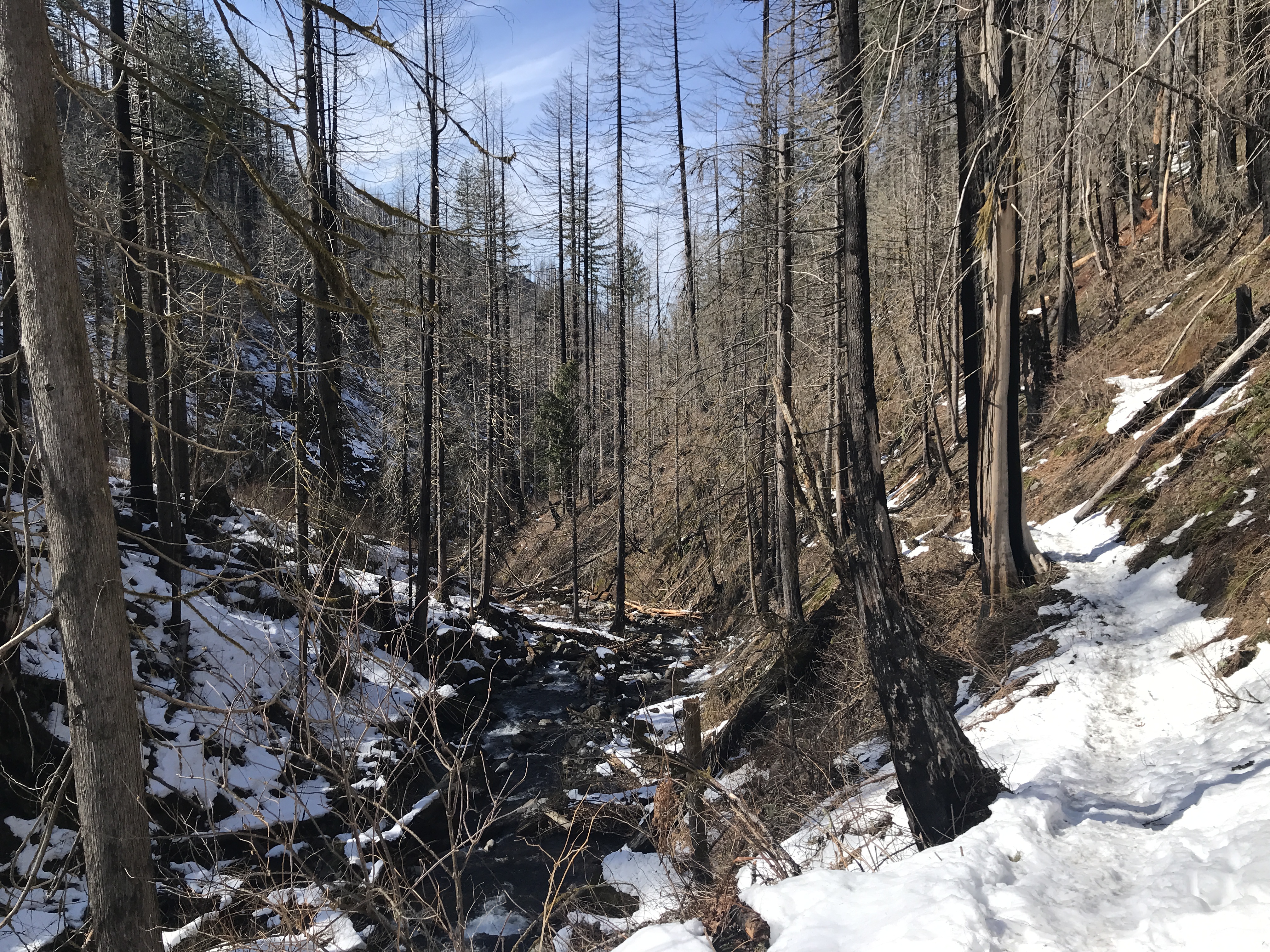
Near the creek, there wasn't much snow to contend with and I was walking on bushes and rocks with my snowshoes. Time to take 'em off. 

To the Saddle

From Hardy Creek it was bare road but as I made my way up towards the Hamilton Saddle, there was more snow but still no need for snowshoes. On the first straightaway, I was doing okay with my boots but slipping a little. I got out the microspikes and forged ahead.

My pace was slowing and I wondered if I had the energy to make it to the top of the Equestrian Trail. I set small goals like I'd pick a tree stump in the distance and just get to that. Then, I'd find another and hike to that one.

At a certain point, I just focused on my steps and pressed onward.

When I saw the sign for Don's Cutoff Trail, I was elated. Woohoo! I made it! The views were spectacular. I could see Table Mountain, Dog Mountain, Bonneville Dam.

The Descent

Even though there were 6 or 7 cars in the parking lot when I started, I never saw anyone on the trail the entire day. All I saw were fresh footprints of people, dogs, and maybe a wolf or coyote.

Saturday, March 18, 2023

Hike: Devil's Rest via Wahkeena Trail, Corbett, OR


Getting There

The weather was amazing, the temp were in the upper 60s and blue skies for miles. 

I took I-84 east and parked in the Multnomah Falls parking lot between the eastbound and westbound lanes. Plus, real or imagined, I'm guessing this parking lot is "safer" due to high turnover and cameras.

The lot was filling up but there were still a dozen open spots.

The Hike

Length: 12.05 mi
Elev. gain: 3,386 ft
Moving time: 5:27:28
Avg pace: 27:11
Calories: 3,295
Total time: 6:17:56

AllTrails map

Took advantage of the gorgeous weather and headed up to Devil's Rest via Wahkeena Trail (420). I managed okay with just boots/microspikes but would have been easier w/ snow shoes on the Devil's Rest Trail (420C).

I'd planned to loop back to the car via Multnomah Falls but when I reached the junction, I kept on going up the Larch Mtn Trail (441) for about a mile. 

Then, I doubled-back toward Wahkeena Creek and took the Vista Point Trail (419).

Wahkeena Trail


View from Devil's Rest

Devil's Rest Trail

Larch Mountain Trail

Vista Point view


Saturday, March 11, 2023

Hike: Hamilton Mountain, Little Hamilton, Little Beacon Rock, N Bonneville, WA


Getting There

Take WA-14 from Vancouver, WA east toward N Bonneville.

Just after Doetsch Ranch you'll see the Ranger Station on the north side of the road just before the Beacon Rock parking lot, then another road across from the bathrooms. The road winds up the hill for a bit.

The Hike

Length: 6.82 mi
Elev. gain: 2,231 ft
Moving time: 3:18:22
Avg pace: 29:04
Calories: 1,996
Total time: 4:07:35


Another snowy hike up Hamilton Mountain. I post a lot of photos of this area. Definitely my go-to spot because it's relatively close, still presents a challenge, and the constantly changing conditions are beautiful to photograph.

Even though the parking lot was pretty full and the overflow was available near the campground, I didn't see that many people on the trail. Usually folks just go to Rodney Falls and back. 

I didn't encounter snow until I started traversing the backside of Little Hamilton. It was really slushy and soft. There were puddles of icy water so I tried my best to avoid testing my boots on their waterproofing.

For the entire ascent I went without extra traction. It was slippery at times but no major issues.

A trail runner passed me. I'm always impressed that someone can run up the mountain and back with light clothing and just minimal supplies (water, snacks). The person had shoes with extra wide treads for extra stability and surface area for these kind of conditions.

Reaching the top is mostly ceremonial but the views are often really good when it's clear. The trees prevent are good 360° view but you can see Table Mountain, Dog Mountain, the Columbia River, and Bonneville Dam. The snow level at the top was higher than it was last time so you are a bit higher up. I was able to see the river to the west through the branches.

I've been wanting to do the Saddle-Hardy Creek Loops but it just hasn't been in the cards lately due to the snow. I saw footprints heading down the ridge. I know it's doable but judging by the conditions last Tuesday, the Equestrian Trail is about 6-8" deep. I have no idea what shape the Hardy Creek trail is in at the moment. (Need to budget another hour or so.)

At the top, I put on my mini-gaiters and microspikes for the descent. I discovered I'd lost one of my hats. There wasn't anyone around so I knew I'd see it on the way down. Right after I started the return, I heard some grunts from a guy. Just when I saw him, I saw my hat. Woohoo. He asked how much further. I said another 50 yards and noticed the running shoes. SMH.

Further down, I encountered this guy's two buddies, also not dressed for the conditions. One guy was having a helluva time in this tennis shoes and cotton hoodie. They were loud but I tempered my annoyance.

The guy from earlier appeared from the top. He said he was underwhelmed by the top. I get it but also recognize that a lot of people don't appreciate the simple things. Every time I hike here, there some doubt that I'll make it due to conditions or fitness or injuries or something. I'm 50 years old with a disability. (Oh, the youths :)

I passed another group where the lead person was in shorts, t-shirt and was carrying cotton sweatshirt. Why!?

I made my way up the side trail for my requisite visit to Little Hamilton. Not many folks had been up there since the last snow fall and they hadn't followed the actual trail very well. 

The views were gorgeous as usual.

As I made my way out of the snow, I stopped to remove the microspikes. Good to be back on dirt/mud.

My boot and pant legs had been cleaned with the snow but now I was getting dirty again.. Oh well.

Near the Hadley Grove junction, a guy and girl were hiking up toward Rodney Falls. Guy had his shirt off.. It was 40 degrees. I don't get the bravado thing.

I headed towards Little Beacon. When I reached the saddle, there was a couple taking photos. I zoomed up the steep hill and had the place to myself. The lighting was amazing. I took off my pack for a min. It wasn't long before I heard that couple. Since I'd been up there numerous times, I figured I'd let them enjoy it. Their English was broken. I hope they didn't think I was leaving because they'd showed up. I was giving them space but doubted I could convey that quickly. I smiled and pointed over my shoulder that there were more great views behind me.

Another great hike. My left ankle and heel felt pretty good. Overall, a success.

Upper part of trail

Rainbow over Table Mountain

Beacon Rock from Little Beacon

Hamilton Mountain from Little Beacon

Columbia River

View through the trees


Columbia River from Little Hamilton

N Bonneville

Columbia River

Heavy snow but it's soft

Snow on trail near the top

The Hamilton summit

Upper trail


Tuesday, March 7, 2023

Hike: Hardy Ridge + Equestrian Trails, N Bonneville, WA

Selfie on Hardy Ridge Trail

Getting There

The trailhead is accessible from the Equestrian Camp Parking Lot, a bit west of Beacon Rock & Hamilton Mountain.

Take WA-14 from Vancouver, WA east toward N Bonneville. Just after Doetsch Ranch you'll see the Ranger Station on the north side of the road just before the Beacon Rock parking lot. The road winds up the hill for a bit. Keep a lookout for the the Equestrian Camp turn off.


The Hike

Length: 6.84 mi
Elev. gain: 1,394 ft
Moving time: 2:51:33
Avg pace: 25:04
Calories: 1,726
Total time: 3:08:12

AllTrails map


Last min hike at Beacon Rock State Park. I was intending to hike to Phlox Point via Equestrian Trailhead but found the Hardy Ridge Trail tough without snow shoes. The snow was slushy and soft so I ended up post-holing a lot. I turned around before I reached the switchbacks. 


Hardy Ridge Trail

Looking west from Hardy Ridge Trail

Hardy Ridge Trail

I thought I might be able to make it to the Hamilton Saddle but it was getting "late". The snow on the Equestrian Trail was heavy and not much different than the other trail. I only made it to the Hardy Creek Trail (picnic bench).

While I didn't reach either Phlox Pt or the Saddle it was still good to be out in the snow and trees.

Hardy Creek

Hardy Creek Trail/Equestrian Trail junction

Friday, March 3, 2023

Hike: Wahkeena-Multnomah Falls Loop II, Corbett, OR


From Multnomah Creek Bridge on Larch Mtn Trail #441

Getting There

Another outing where I was "all dressed up but no where to go." Well, there were plenty of options but I didn't want to do Forest Park or Hamilton but wanted something familiar. I considered Cape Horn but naw... back to the Multnomah Falls. The Tripcheck cam showed a mostly empty parking lot.

The closer I got to Troutdale, the worse the weather looked in the Gorge. The fog was dense and it was raining.

Again, I liked being able to park between the eastbound and westbound lanes, instead of having to get on the Historic Hwy. Plus, real or imagined, I'm guessing this parking lot is "safer" due to high turnover and cameras.

I pulled into a parking spot and watched the raindrops on the windshield. I thought about the recent snow and now rain making the hike slushy and damp. I made myself a "deal". I would just do a short hike up the Wahkeena Creek to the Vista Point view and back (or as far as I could go.)

I suited up and walked to the tunnel under I-84 to the road.

The Hike

Length: 6.01 mi
Elev. gain: 1,693 ft
Moving time: 2:27:42
Total time: 2:48:45
Avg pace: 24:35
Calories: 1,486

AllTrails map

The Return Trail #442 between Multnomah Falls Lodge and Wahkeena Falls was clear of snow. I was able to go without spikes for quite awhile.

On the lower part of the Wahkeena Trail #420 (the switchbacks) was also snow free for the most part. In fact, I was well into the middle section before I stopped to put on the microspikes. The trail was well-traveled and packed down but the rise in temperatures and rain had turned the ice into unstable slush. I was slipping a bit but was glad to have the added traction.

Near the top of the canyon, there was a spot on the trail that gave me pause. The snow bank had given way showing a sheer drop, one of those false steps that changes your day. Yikes. I hugged the hillside.

The burn area (see the bowl below Devil's Point) was easier travel but the slushy did add a bit of resistance. The contrast of white snow and few burned tree stumps created a canvas of shapes that looked like people or large animals. I stopped a few times and stared to look for movement but eventually I realized what I was looking at.

When I reached the View Point/Devil's Rest junction, I considered my options and fitness. My ankle was aching a bit but I felt good. Devil's Point was not in the cards today and I wasn't ready to head back down so I said 'fuck it' and decided on a loop.

I was mildly apprehensive about the section of the trail past Multnomah Creek. Last time was a bit gnarly.

A hiker that looked under-dressed came the other direction. The sight calmed my own nerves but also thought that the guy in a sweatshirt and cowboy boots. I saw his heel prints in the snow way up here. The guy up was passing was just in a wool fleece and light boots. Here I was with multiple layers and a winter coat on my pack. This gives me an idea for another post about preparedness in different seasons. I asked about the trail conditions below. Seemed like the hazards I'd encountered before were gone. Whew.

At the junction to Multnomah Falls, I saw the steel bridge about 0.1 mile up the Larch Mountain Trail #441. Looked like a good spot for some photos (see below). I'd like to hike up to Sherrard Point sometime.

After a short detour and photo op at the bridge, I started down the final section along the creek. There was a lot less snow so it felt safer on the cliffs past Ecola Falls, Wiesendanger Falls, and Dutchman Falls. The icy slope that was there last time was totally gone. Huge relief.

Back on the paved trail there were lots of people slipping and sliding in the street shoes. A few people kind of smirked when they saw me with pack, boots & poles. Probably thought I'd suited up for the same hike they were doing with high tops and cotton sweatshirts. LOL.

Around switchback 5 of 11, I passed a couple of woman who cheerfully let me zoom by. A few turn later I heard her shout "did you run?".. I looked up and smiled and laughed and waved.

Another good hike. I'm glad I wasn't deterred by the rain. Worth it!


Instagram post text:

Nice loop hike starting at Wahkeena Falls, ending at Multnomah Falls. Mostly snow covered route, pretty slushy tbh. My microspikes were slipping quite a bit even though the trail was well packed down. It was much less scary on the section by Multnomah Creek. When I was here in January, the creek was raging and there was an icy slope (*slide*) below Wiesendanger Falls that you had to traverse. No margin of error. Today, the water level was low and that icy slope is gone.
When I got to the parking lot, it was raining and I pondered if I wanted to hike. So glad I went for it!