Featured Post

2024: My Year in Review

Another trip around the sun! I kept my same hiking goals from previous years: 52 hikes , 365 miles , 84,000 feet . However, I came up short ...

Showing posts with label Ptarmignan Trail. Show all posts

Monday, September 16, 2024

Hike: Mt St Helens Summit, Cougar, WA

Getting There

From Portland: Take I-5 N for 28 miles to Woodland. Take Exit 21 for WA-503 E to Cougar. Follow Lewis River Road (WA-503) for 30 miles. Continue east for another 3.4 miles past Cougar on Road 90 and take NF-83 for Ape Cave/Climber's Bivouac. Take this road for 3 mile then turn left on FS-81 for 0.4 miles. Turn right onto Road 830 (dirt/gravel) and take that to Climber's Bivouac (2.2 miles).

I did make a couple of stops in Woodland. First, I went to Grocery Outlet to get a few more things that I forgot to get at New Seasons: bananas, plus I read that peanut butter and whole grain bread was a good food for sustained energy. I just ate the bananas whole but might be good to put in the sandwich as well as some honey.

I remember in the past, I've eaten a big slice of vegetarian lasagna but didn't want to buy a camp stove to heat it up. When I've stayed in Woodland, I've gotten to-go food from Mali Thai Cafe. I always remember it was piping hot and took awhile to cool down enough to eat. I thought it'd be a perfect noodle dish + protein (chicken) and would still be warm when I reached the Climber's Bivouac.

Oops. I forgot to get Gatorade at either of my grocery trips so I stopped at the Lakeside Country Store. I grabbed two bottles of sugar-free Gatorade and one more Clif bar to throw in my pack.

On the road up camp, I passed Ranger Trevor but he didn't recognize me in my car and not in MSHI colors.

I circled the lot once and found a good level spot. It was where I camped in 2022, the year I didn't reach the summit. No bad omen. LOL. It was adjacent to the pit toilet. I sent my mom a "I"m here message" on the Garmin but realized I had a cell signal: not sure if the iPhone 15+ has a better radio or cell coverage is better at camp. I noticed my coordinates were missing from the message (again!) so I sent a text message. I set up my cocoon in the back of the Jeep and ate my dinner. Soon it was dark and I got situated inside.

I slept pretty well but remember some cars that drove through the parking lot with high beams on (argh!) and one person that sat there with headlights on and foot on the brake. I was mildly annoyed thinking this person was idling and spewing exhaust just sitting there in the dark at 11pm. I realize I could tell if the engine was on and the tail lights really didn't illuminate my situation. 

I set an alarm for a 6am departure but when the time came, I was slow to get out of my sleeping bag. I eventually got up and started getting ready. I hit the trail at 6:40a.

The Hike

Length: 8.80 mi
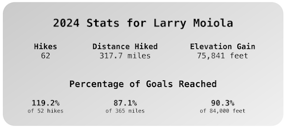
Elev. gain: 4,531 ft
Moving time: 6:07:45
Avg pace: 41:47
Calories: 3,722
Total time: 9:23:49


Backstory

I've been down lately as the summer is coming to a close. There were some high points (volunteering with MSHI & mentoring new folks, working with WTA on trail work and log outs, getting my vest for 25 days of service) but there were some low points sprinkled in (dropping a large rock on my chest, a bout with vertigo and Benign paroxysmal positional vertigo (BPPV)). I also wasn't sure where I would be after a year living off Alberta but this time has buzzed by quickly.

Last time I did this climb (Sep 6, 2023), it was just a few days before I closed on my house on N Argyle (sale). The summer of 2023 was very difficult and this hike was a triumph of will, perseverance, and fitness, somewhat in spite of Rheumatoid arthritis. The previous year I had come up short on my climb, having turned back on the last section of trail. I was mentally beating myself and hadn't had the right foods/fuel.

I thought about Fred Beckey and how he continued to climb until he couldn't. Would I make it this time? I've always told myself that I was richer from my experiences and could find solace in those memories when the time came when I can no longer hike. I'm not sure I believe it but I also plan to drag my ass to the trail in whatever condition I'm in. Maybe I won't be able to tackle Hamilton Mtn or MSH but I'll put up with the hassle and discomfort to be in nature, even if the risk for self-rescue is higher. I remember seeing a guy with cerebral palsy that was out on the trail with his dog. I saw my future self in this person.

This year, I was determined to make it again despite some self-doubt. Also, I've been having R foot issues that threatened to thwart my attempt this year. I rented some Scarpa boots from the Mountain Shop on NE Sandy Blvd so my foot didn't flex and cause pain.

The Wooded Section

I got on the trail at 6:40a, still dressed for the cool weather. I imagined reaching the summit and convincing my brain that I could do it again. The power of the mind is potent. I took moments to appreciate where I was and how fortunate I am to be able to visit this place. The day was shaping up to be incredible with the weather and it made me smile.


Onto the Rocks

At the treeline at 4800', I met a guy that was resting on a rock. I said something about the clear skies. He'd just moved to Oregon and was looking forward to his climb. I mentioned some other nearby trails and wished him a successful summit.

Up on the first rock field, I'd stopped to shed a layer and adjust my pack when he caught up. A cloud had blown in front of the sun. I told him, "crap, I hope I didn't jinx the weather". As I continued up I waved and said "one step at a time, be safe".

Even though I had my sights on the summit, I set short term goals. The counting system worked well and setting milestones like a big rock or a lodge pole for my next break or water stop helped me keep my pace and stamina. I tried not to look towards the top too much because it seemed so far away. I was the tortoise in the The Tortoise and the Hare. I had plenty of time and no where to be.


The Vertical Beach

I realize the "beach" is a bit higher up but I knew I'd successfully made it passed the series of rocky steps and actual climbing. From here to the top is just a steep walk on loose pumice sand. I didn't take any photos of the vertical beach but it is deeper than this lower part. Two steps up, one step back. Hiking poles are key for minimizing backslide. I did have to pinch myself. I was feeling good physically, emotionally, and it is such an incredible place.


The Summit

Hell yeah!! I made it. I counted 10 or 12 sets of 20 on the last section. A couple was stopped: the guy was sitting and massaging his leg, staving off a cramp. I stopped and chatted with his partner. She recognized my MSHI patch and commented. It was a good diversion for me. I was outside of my head. I said I'd see them at the top and kept pushing.

When I finally took those last steps to the ridge and saw Spirit Lake, I was so fucking happy. This was my third time to the summit. I was really here. I felt pretty good. There wasn't any wind, the views were amazing in all directions. I could see Mt Rainier (Tahoma), Mt Adams (Klicktat/Pahto), Mt Hood, Mt Jefferson (Seekseekqua), and possibly Mt Washington.

I saw the couple I'd seen on the trail. We chatted some more and I told them I didn't want to leave but knew there was still a 3hr hike back down to the car. I mentioned the trail on the west side of the ravine below the boulders was a bit faster than weaving through the rocks. (I realize there is a similar trail between the rocky trail and my "shortcut"; maybe next time!).


I kept pace with several groups of hikers on their descent. One person asked me the best route but they were doing just fine and pulled ahead after a short while. I mentioned to one about not wearing gloves for the scramble down the boulders. I didn't mean it anyway other than I know my hands would have been shredded without my gloves.

Here is a shot of my alternate path. Maybe folks have used this route as evidenced by the boot prints in the soft pumice sand. It's not so much a shortcut as a path that has fewer obstacles to weave around. From the looks of it, there is a similar path on the other side of the ravine, below the lodge pole route I'd take up.

The "Shortcut"

Back to the woods

The last 2.5 miles was tough. My legs were so sore and my feet were complaining loudly. Each step was painful but I knew I was almost back to the forest trail which offered a softer dirt trail and shade. I'd left my sunscreen in the car so I knew my face was sun burnt.

A family of four had passed me on the rocks. I chatted with one guy that was waiting for his dad. We agreed it was great to be back to the trees. I wished him well and waved to the mom and the other son as they waited.

I tried my best to ignore the pain in my feet. I cursed at the check steps and exposed roots on my way down. The gift that keeps giving. LOL. I purposefully didn't check my map. I knew the trailhead would appear around the last turn eventually.

When I saw the sign about needing a permit after 4800', I was so relieved. I'd made it! Fuck yea!

Note of caution

Even though I consider this hike a resounding success, I have to acknowledge the three times that could have been terrible. Twice, I'd almost lost my footing on the boulders which could have resulted in a nasty fall and injury. I also had a close call on the shortcut. It's a reminder that despite it's popularity, accidents can happen, usually on the descent when you're tired and getting a little sloppy. In the end, they were close calls and not incidents that caused injury and/or required assistance. Whew. I wouldn't change a thing. 

What's next? 

Maybe Mt Adams, South Sister, a trip to Muir Camp, somewhere else. I think it's time to switch it up. I've done MSH 4 times with 3 summits. I want to bag some other peaks... while I can.

Thursday, September 7, 2023

Hike: Mt St Helens Summit, Cougar, WA


Getting There

From Portland: Take I-5 N for 28 miles to Woodland. Take Exit 21 for WA-503 E to Cougar. Follow Lewis River Road (WA-503) for 30 miles. Continue east for another 3.4 miles past Cougar on Road 90 and take NF-83 for Ape Cave/Climber's Bivouac. Take this road for 3 mile then turn left on FS-81 for 0.4 miles. Turn right onto Road 830 (dirt/gravel) and take that to Climber's Bivouac (2.2 miles).

I realized about half way between Woodland and Cougar that I'd left my hiking poles in my garage in Portland. It's weird how the mind works: I was listening to music and enjoying a leisure drive and it hit me. Fuck! I pulled over and did a search for the nearest store that would have some. I didn't want to drive all the way back to Portland. I thought it'd either be Woodland or Battle Ground. 

I found a Walmart in Woodland and double-backed. I wandered the section of the store where they were sure to be but I didn't see any trekking poles. I approached a store employee and asked. Yes. Aisle whatever. I panicked for a second, thinking they were out of stock but hooray!, a pair of aluminum poles. I grabbed 'em and a small cooler. (I'd also left my cooler at home and had guacamole and hummus from my stop at the Woodland Safeway a hour earlier). At this point I wanted to top up the gas tank and stopped at a AM/PM near the Walmart. I grabbed a small bag of ice and headed back out Lewis River Road. Whew!

When I got to Climber's Bivouac, I spent an hour or so organizing my stuff and putting snacks in plastic bags for the hike. There were people on the other side of the parking lot but I had my side to myself. It was pretty quiet since I didn't have my little Bluetooth speaker. Eventually, it got a bit cool and dark and I got in my cocoon in the back of my Jeep. Even with the yoga mat and blanket, I didn't have enough padding. Argh! Lying on top my sleeping bag helped.


I was awake every few hours as cars pulled into camp, their headlights illuminating the place briefly. Once I was in the sleeping bag, I really felt the lack of padding. 🤣. Luckily, there was just enough cell phone signal to stream some tunes from Spotify.

Around 4am I saw a few hikers with their headlamps walk by. I wasn't ready. Around 5:30a I put on my hiking clothes to warm them up in the sleeping bag. I waited until about 6am to get out of truck and take a wazz. I ate a banana and drank 1/2 can of maté: breakfast. I got on my boots and pack and walked to the sign-in board. There was just enough morning light to see my permit to enter the number into the register. I realized I might not have locked the car. I tried to see the taillights flash but couldn't. When I got back to the car, a big group was getting a pep talk. They were recruits or army reserves, about 10 guys. I pretended to get something out of the truck and consciously locked the car. Here we go!

The Hike

Distance: 8.18 miles
Elevation Gain: 4,570 ft
Highest Elevation: 8,258 ft
Total Time: 8h7m
Ascent: 6:15a - 10:45a (4h30m)
Time at Top: 10:45a - 11:35a (50m)
Descent: 11:35a - 2:22p (2h47m)


I started the hike through the forest. No other climbers were around. It was nice and quiet and I got adjusted to my pack.

At 6:56am, I was close to the Loowit Trail and sun was coming up.

At 7:09, I reached the treeline at about 4,800 ft. This is the end of the Ptarmigan Trail. I remember reaching this point back in 2020 when the idea of doing this climb was planted. I was just out exploring the lakes/reservoirs and drove up to Climber's Bivouac on a whim and did the hike. I had no idea what was involved.

I made my way up the Monitor trail and stopped to enjoy the views to the south and above me. A couple of pair of climbers past me and I passed a father and daughter that were doing this hike for the first time. I talked about my volunteer role on the trails below.


I didn't take any photos between 9:13a and 10:53a, after I'd reached the top. About 1/2 way up in the boulders, I synchronized with that group of military guys and chatted with a few of them. It felt good to have them as motivation and trail companionship, at least in my mind. I wondered how my fitness and age stacked up with the older guys and younger ones. The leader was a SAR guy and I overheard him talking about the gear he'd bring on these rescues.

There was one kid in the group that was struggling. Per the trailhead pep talk, the group took breaks every so often and wait for everyone to catch up. He was getting advice from the older guys. While I didn't revel in his discomfort, it reassured me that I was doing pretty damn good. All the worry about my recent arthritis symptoms and general anxiety about not reaching the top, thinking about my 2022 attempt was in my head.

I kept striving to reach the next lodge pole or rock or whatever: the counting method from Bear Grylls, thinking about Joe Simpson in Touching The Void. Breaking the big "thing" into smaller bits, like I have with Hamilton Mountain.

At the GPS station, I could see little dots of the people on the rim. The goal was within sight but it was still a 0.5 mile away. I was a bit nervous here. This is where I'd turned around last year. I continued hiking with the military guys and passed a couple of hikers. I just kept aiming for my next goal/milestone.

Eventually, the people at the rim looked a lot bigger. I was really going to make it! Fuck yea! I did my best to find other hikers' footprints and used them as steps. 

When the rim was close, I estimated I had 30 steps to go! I counted each one and it was actually just 32 steps. I made it!

I walked up to the high spot to the right of the end of the trail and took this photo! I turned and snapped the photo of that group of 10. They were hanging out on the other side. A pair of hikers I'd seen way below were sitting near them, eating sandwiches.


I walked towards the "true summit" but opted not to go. I was glad to be up there and regret not going a little but decided I'd head over there next year. I just enjoyed the views and the silence from up there. I'd purchased safety goggles because I'd anticipated wind and dust but it was perfect up there. It was so quiet you could here little rock falls in the crater but they were so small, I wasn't able to place them as there wasn't any dust.

True Summit from my spot on the rim

Shoestring Notch and Mt Adams

South view w/ Mt Hood, Mt Washington, Mt Jefferson

Crater view with Mt Rainier in far background

Panoramas


Friday, September 16, 2022

Hike: Monitor Ridge Climbing Route and Ptarmigan Trail, Mt St Helens, Cougar, WA


Footpath map

Getting There

I left around 3:30p and made it there just after 5p sometime. I took I-5 North to Woodland. Then WA-503 E toward Cougar. It's about 30 miles to the town and the turn off for Climber's Bivouac is another 3.5 miles.

Follow NF-83 for 3mi. When you get to the clear cut area (ugh!) look for NF-81 and veer left. It's another 1.5mile of pavement to 830 Rd. It's a 1/2 mile to the campground on a dirt road.

I opted to make a cocoon in the back of my Jeep rather than setup a tent etc. I found a level spot this time near the trailhead. 

There were people arriving all night (11p, 1a, 3a, 5a). I didn't sleep very well and I got moving around 6am. I was on the trail at 6:20.

The Hike

Distance: 6.94mi
Elevation: 3,560 ft
Highest Point: 7,289 ft

I passed a few people on the way through the forest. I made good time but I felt a bit sluggish, low energy. A lemon (yellow flag). I forged ahead.

I started the technical stuff above the tree line. I was new but familiar the same time. I tried to visualize the route I took last time and keep track next to the lodge poles.

I could hear a group below me in the fog and see three hikers about 1000 yds ahead of me. I snacked on a cliffbar to try to re-energize but I was taking a lots of micro-breaks.

When I reached the top of the ridge section, I mentally prepared for the boulders. They were a bit daunting but I was stoked to keep reaching the next marker and pushing ahead.

A group passed me but when they stopped to wait for more of their group I kept going.

Eventually I made it out of the boulders and started up the pumice. My legs were pretty heavy at this point. Three hikers passed me and zoomed ahead. I could see the top.

I was taking longer breaks and taking fewer steps between them. I decided to conserve my energy to make a safe descent. The self-imposed pressure to reach the summit was released and I felt better. I am still a bit disappointed to not reach the rim.

In hindsight I think this was largely a nutrition problem. I didn't eat enough of the right foods the night before and in the morning to fuel my body for such an undertaking. I vow to make a third hike next year. It motivates me to keep training and learning about how proper nutrition can really make the difference.

I should have stopped for longer to see if I eating a couple more power bars would have helped. I had plenty of time. 

In the end I made it back to the car around 1:30.. about a 7 hr hike. I didn't have any injuries and didn't need any help. A success in its own right.


Wednesday, September 15, 2021

Hike: Mt St Helens Summit, Cougar, WA


AllTrails map
Requisite selfie from the summit

Getting There

I left Portland around 12:30p and stopped New Seasons to get some supplies. The drive to Climber's Bivouac takes about 2 hrs if you go through Cougar.

This time I took the extra time to go passed Merrill Lake. I stopped at the campground to take some photos.


Merrill Lake


I was there early enough at the campground to have my pick of campsites. I parked at one and started to get settled but a couple was leaving across from me and said "this one is a good spot". They all were but I moved over there anyway. I didn't even set up a tent. I just made a cocoon in the back of my truck.

I passed the time by snacking, listening to Alan Watts, and observing the birds that were everywhere. I even feed them some almonds.

About 6pm it was getting darkish and I have a horrible thought that I'd left my garage open. I tried and tired to connect to my cameras or garage app. The cell signal was poor but not out but my efforts were in vain.

I threw what I had in the back and started driving down the hill. I'd was planning to drive to Cougar to check the camera or app. Fortunately, just a few hundred yards down the hill the cell coverage really improved. I was able to confirm my place was locked and secure.


On the way back to my campsite, I stopped to snap this photo:

View from 830 Rd to campground

The Hike

Distance: 8.20 miles 
Elevation Gain: 4,583 ft  
Highest Point: 8,278 ft

I really didn't sleep well. The slight incline was enough that I keep sliding down in my sleeping bag. Argh! :) 

Around 3:30am I saw the high school kids across from me were stirring (headlamps). (Turns out they were going for a sunrise summit). I waited for another couple hours. Around 5:45-6a some cars arrived and I could see some lights at nearby camps.

I finally just got going around 6am. By 6:30a I was ready to go and walking to the trailhead to sign in.

I filled out my information (permit number, # in party, etc) in the trail register.  Holy shit. This was really happening!

The short version:

The first 2 miles is easy through the forest, a good warm up. I saw two groups but passed them.

When I emerged from the forest and onto the rocks in the Restricted Zone, I didn't see anyone for awhile.

It was challenging but I finally saw one guy a couple hundred yards ahead of me. I kind of followed his path between the trail markers (lodge poles).

Making progress up the Ptarmigan Trail


View of Mt Hood

In the middle of the rock field, I saw more people. By the time I reached the ash section, there were about 10 of us on the trail. The ash field was the great equalizer.

I was the last in the group but matched the rests the guy closest to was taking.

Fellow travelers

It was mentally taxing but soon I was seeing the others reach the rim and spread out. The people got bigger and bigger (my only way to judge the distance). 

My last few steps were incredible. All the preparation and effort to get there was about to pay off.


View of MSH crater, Spirit Lake, Mt Rainier

View of 'true' summit from top of the trail

It took me 4 hours to get up there. I spent about an hour at the top. I was exhilarating to continue to the 'true' summit. I saw a person way off in the distance at the cairn. The three older guys I saw were heading there so I did too. 

It wasn't without some hesitation. I began to rationalize NOT going but I was so early, around 11am. I said to myself "I'm going for the Deluxe Tour". I'm not coming all this way to not explore EVERYTHING I could.

It took me 3 hrs to get down.

I was slow going through the rocks. I knew beforehand but climbing down is a bit more sketchy than climbing up.

I sorta lost the trail for a bit but found some alternate routes. Those three guys I'd met were cruising down straight path while I wormed by way down between the lodge poles. I traversed over there and knew instantly why it's a downhill only route: deep sand/ash. 

I was so stoke to reach the forest. I was mentally fatigued from climbing over the rocks.

I reached the trailhead around 2:30p. Total Time: 8 hrs (almost to the minute).