Thursday, February 22, 2024

Hike: Hamilton Mountain + Hardy Creek Loop, N Bonneville, WA


Getting There

Just after Doetsch Ranch you'll see the Ranger Station on the north side of the road just before the Beacon Rock parking lot, then another road across from the bathrooms. The road winds up the hill for a bit.

For a beautiful day, there were only about 8 cars in the lot so ample open parking spots. I parked near the playground + bathrooms.

The Hike

Length: 9.42 mi
Elev. gain: 2,405 ft
Moving time: 4:38:50
Avg pace: 29:35
Calories: 2,816
Total time: 5:22:55


What a difference a month makes! We've had a couple of periods of springlike weather in February in Portland while the Gorge has had more wintry temperatures and precipitation. The Oregon side of the Gorge is more often shrouded in shadows while the Washington is getting more sun.

The Hamilton Trail is snow-free all the way to Baby Hamilton (top of switchbacks) where it becomes patchy and really slushy. There was a little on the short trail up to Little Hamilton but it was clear. The views were epic. I wanted to stop here on my ascent since I was planning to do the Hardy Creek loop.

The views and weather was amazing. When I reached the last set of switchbacks in the trees, I was pretty always on snow. It was so soft, it slowed me down a bit. Near the top, I could hear a pair of hikers on their way up. I stopped at the top to enjoy the views and they arrived a few minutes later. The snow pack at the summit made it a little easier to see over the bushes toward Bonneville Dam, Dog Mtn/Wind Mtn & the Columbia River to the east.

A few minutes after that, a pair of hikers arrived from the north, the Saddle. I asked how it was and they reported it was clear but the traverse was a bit challenging.

I wished the four other hikers a good descent and rest of their trek and set out towards the Saddle. For a while, there were a few areas where I had to duck under low branches and tread over postholes. I sort of thought they had exaggerated a little, NBD!

Well, I finally encountered some blowdown and it was definitely tricky to get around, esp. since the snow was so soft and unstable. There was one spot where I had to climb down, then back up and around a fallen tree. The snow was really deep here. I had to step down again about 4 feet to rejoin the trail.

As soon as I stepped down, the snow under my foot gave way and I tumbled in slow motion into the tree. Crikey! My hand and the handle of my pole disappeared into the snow. I was a bit like a turtle stuck on my back. I grabbed the tree branch or root and pulled myself up. Fortunately, no snow got into my pack and I didn't hurt myself.

I dusted myself off and continued on. A little reminder it could have been worse and to be vigilant. I'm careful with my movements but stuff can happen.

The snow still covered the trail below where it usually clears out. It wasn't until I reached the Saddle when I found bare rock again. There were a few patch but the sun and warm air had melted most of it. On the far side, a large raven landed near me and I snapped a few pics.

I continued on. I decided to take the Equestrian Trail down instead of Don's Cutoff, my usual route lately. The snow made it easier to walk on the rocky road. I imagined that couple coming up this section. It's long and straight. 

Along the way, I stopped several times to revel in the beauty. "So fortunate to be able to come here."

There is a lot of work for WTA crews to clear the trail. Near Rodney Falls, a large tree has fallen across the trail in two spots where you have to crawl through a jumble of branches and roots.

I kept catching up to a pair of hikers so I stalled to add a cushion between us.

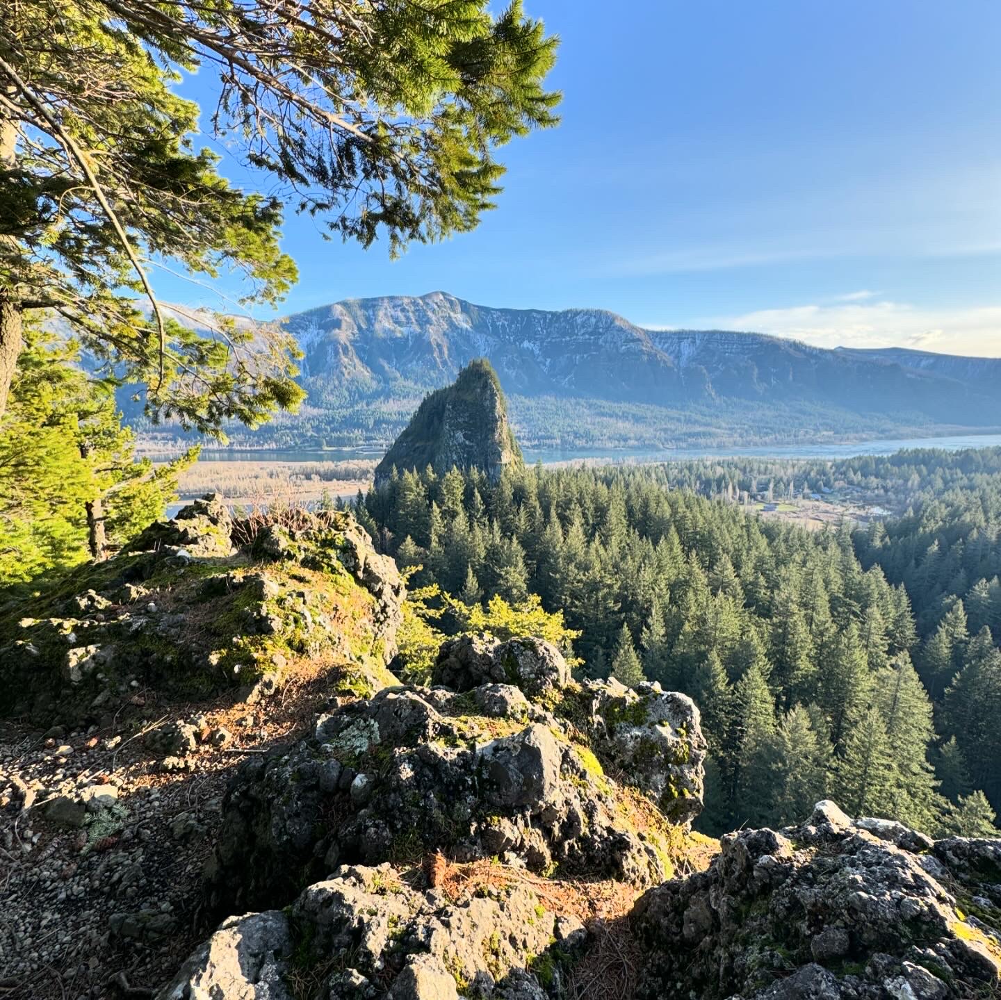
The sun was still pretty high in the sky but I knew the views & lighting would be great from Little Beacon. My legs and feet was really sore but I mustered the energy to do one last scramble to the viewpoint. I believe I was crawling up an ancient volcano plug.

Epic hike!

 
The Saddle looking northwest

Rodney Falls

The trail by Little Beacon

View from Little Beacon

Another view from Little Beacon

Little Hamilton & Hamilton Mountain

The Saddle

Beacon Rock from Little Beacon

Bonneville Dam


The Hamilton Mountain Trail

Equestrian Trail

Tuesday, February 13, 2024

Hike: Devil's Rest via Wahkeena Creek, Corbett, OR


Getting There

The weather was amazing, the temp were in the upper 60s and blue skies for miles.

The last time I tried to hike this trail from the I-84 parking lot, the Return Trail was iced/snowed over and there was no way to safely walk the road.

This time I took the Bridal Veil/Angel's Rest exit from I-84 E, then found a spot at Wahkeena Falls.

The Hike

Length: 7.51 mi
Elev. gain: 2,687 ft
Moving time: 3:39:30
Avg pace: 29:13
Calories: 2,216
Total time: 4:00:55


I'd been wanting to hike this trail again. I did the Wahkeena-Multnomah Falls loop back in December (December 16, 2023). The last time I hiked to Devil's Rest was 11 months ago (March 18, 2023) and it was pretty snowy.

This time I encountered a small amount of snow on the switchbacks to Lemmon's Point and another patch between Lemmon's Point and Fairy Falls. Beyond that, it was gorgeous and spring-like.

There was a short scramble where a landslide had covered one of the switchbacks below Fairy Falls.

I was kind of surprised that there were almost no trees down on the flatter section of the Devil's Rest Trail. I passed a couple going in the other direction and one of them commented on the MSHI patch. I decided to start attaching it to my pack on non-MSH hikes since I ran into a MSHI Naturalist classmate on the Angel's Rest Trail who was wearing theirs.

In hindsight, I realized I was wearing a red beanie and had my red Kahtoola MICROspikes on my strap. I must have looked sort of "official" from afar.

When I reached Devil's Rest, I was by myself. I considered if I had time to hike over to Angel's Rest or just double back the way I came and checkout Vista Point Trail. As I was resting, another hiker showed up and climbed up the other rock.

After a couple of minutes, I looked over and noticed that person was gone. I thought, what if I do the loop from here? It was the Primrose Path. I made sure there I left a bit of a buffer for the other person. I'd tried to come up this trail over a year ago (January 3, 2023) but there was too much snow and no tracks to follow.

While trying to find my way down this unfamiliar route, I tried to keep sight of the other hiker. I checked AllTrails and noticed I had take the Devil's Slide trail by accident. It was pretty steep but I was able to stay on track by following little markers of neon orange plastic tape.

It was longer than I expected and I lost sight of the other hiker. I hoped I hadn't gotten onto an animal trail. I knew the Angel's Rest Trail was down there somewhere and even if I'd had to bushwhack, I'd run into it. I really didn't want to have to climb back up this trail.

I finally made it to the Angel's Rest Trail and familiar terrain. I breathed a sigh of relief. I slowed down my pace and enjoyed the descent. I should have taken some photos from the Primrose Path but I was focused on staying safe on that steep section. I knew I had my InReach and all the stuff I needed in the unlikely event I'd gotten lost. I knew the area pretty well but also that there are steep cliffs and slim chance to hike where I couldn't get down.

All's well that ends well. Great hike in warm weather and blue skies.

Wahkeena Trail

Wahkeena Trail

Fairy Falls

Devil's Rest Trail

Devil's Rest Trail & Wahkeena Trail intersection

Devil's Rest Trail & Wahkeena Trail intersection


Friday, February 9, 2024

Hike: Kings Mountain, Tillamook, OR


Getting There

Take Hwy 26 from Downtown Portland and drive about 20 miles west to Hwy 6 past Banks, OR. From there it's another 26.4 miles to the trailhead. It's about 3.2 miles east of the Tillamook Forest Center. There's room for about 8 cars to angle park and some room for another 6-7 cars to parallel park.

There was only one other car in the lot. As I was starting, I saw another car pull in but I never saw any other hikers besides the owner of that one car I saw in the lot.

The Hike

Length: 5.36 mi
Elev. gain: 2,592 ft
Moving time: 2:49:20
Avg pace: 31:36
Calories: 1,710
Total time: 3:40:21


The weather was rainy-drizzly but the trail wasn't too muddy except in a couple of spots. The last time I did this hike was last Sept when it was sunny and warm. I remember seeing some people mushroom foraging. Today, beside the one hiker I saw near the start, I had the place all to myself.

Being alone out there definitely heightens my senses and makes me a little more cautious but I have to trust my abilities and know that I am prepared with gear for the unexpected. 

As I made my way up, I recalled the people I saw here last time. I know Hamilton Mtn so well, but with new trails sometimes it gets a little jumbled in memory. Remember past encounters helps me gauge my progress, to some extent.

I stopped briefly at the first viewpoint where I had lunch last time but decided to keep going up. There are some steep sections and I knew I had a few more. It wasn't so much the elevation gain but slippery rocks. I took my time and made sure all my steps were stable and secure. I didn't want to twist and ankle or bang myself up since there were no other out hiking.

I passed the beat up picnic bench and zoomed by. I started to see some snow but it was slushy and there was probably melted snow dripping from the trees. I should have put on my pack's rain cover but I didn't. Oops. Nothing in my outer pockets that could get damaged but still want to keep things dry.

The last section on the rocks was a little slippery but I was more concerned about the descent. I ignored that for now and kept pushing for summit.

When I reached the top, I found some snow but it was melting and really slushy. Under the canopy by the Mazama box, I was getting quite wet from the melting snow and rain falling from the trees so I only lingered there for a minute or two. 

I started back down and wanted to get through the rocky section before I stopped for a snack break. I hiked all the way down to the viewpoint I'd passed on the way up. It was foggy but I could see some trees and a patch or two of snow on the steep slope below the summit. I stopped to add electrolyte powder to my water bottle and eat my banana and 1/2 of Clif bar.

Once I reached the less technical part of the trail, I was able to continue at a good pace but I also marvel at the steep trail and what I'd have done an hour before. The incentive to get to the top is a strong motivator. 

As I neared the trailhead, I hoped that my car had not been tampered with. I knew there wasn't much to steal but still worried about broken windows and the sense of invading space. There wasn't much use in worrying about it now and distracting me from the beautiful surroundings.

When I reached the parking lot, my Jeep was the only car as I fully expected, but you never know.

I sent a message from my inReach that I was back to the car and put it on the spare tire to transmit when it connected to the satellite. I took off my boots and realized I hadn't packed a dry shirt for the drive home. D'oh! My base layer was soaked but the fleece layer was mostly dry.

I packed up and drove away.

A ways down the road I realized I'd left the inReach on the spare tire. Fuuuuuuuck. I pulled over to u-turn. I hoped it'd fallen off in the parking lot. I recall I did something similar after leaving the parking lot for Stagman Ridge at Mt Adams. 

It dawned on my to look in the rear view mirror. What if it was still on the spare tire??? I pulled over and got out. Holy cow! It was still there, and how lucky it didn't fall off when I did the u-turn; I would never have found it. Whew! Relieved, I did another u-turn and started for Portland. All's well that ends well!


Sunday, February 4, 2024

Hike: Angel's Rest, Corbett, OR

Getting There

What an adventure! I set out from Portland without knowing where I was going to hike. I just knew I wanted to get outside for this rare, unseasonably warm weather. I've been wanting to get back to Wahkeena Falls #420 trail since the snow and ice storm in January.

When I reached the parking lot, it was windy and the Oregon side of the river was in shadow. Even though I'd just done Hamilton, the sunny side of the river (WA) looks so much more appealing. I blasted by the Multnomah Falls parking lot and continued onto Cascade Locks. I crossed the bridge and headed to Stevenson to get some snacks. 

On the way back, I decided against Hamilton and crossed the river again, another $3 and decided to go for the Wahkeena hike after all. I parked and suited up and was ready for the climb. The parking lot was nearly full so I didn't want to bother with the Multnomah Falls hike. I crossed under the freeway and headed to the traverse trail #442. Unfortunately, there was no way to reach the trail due to deep snow & ice. There was no way to walk along the road, too sketch.

Reluctantly, I walked back to the car and wondered if I was going to hike at all.

I decided on Angel's Rest. There's no exit from the westbound side of the I-84 so I had to go all the way to Rooster Rock and turn around. I backtracked to the Bridal Falls exit and found the main parking lot and overflow lot both full. Sad face! Frustrated, I headed south on Hwy 30 hoping for a last option, Latourell. Dammit. It was closed for repairs and maintenance.

I was dressed for a hike and had no where to go. It was getting late in the day for a long hike, ~2pm. I decided to give Angel's Rest another shot. There still wasn't any room in the main lot but I found one spot next to the road. I was weary of getting my car broken into.

The grabbed my pack and poles and started the hike.

The Hike

Length: 5.19 mi
Elev. gain: 1,490 ft
Moving time: 2:22:32
Avg pace: 27:29
Calories: 1,439
Total time: 2:44:23


It worked out in the end. The trail was in great shape. A little bit of mud and ice but otherwise, well groomed. 

I passed a bunch of hikers on the way down but it never felt crowded despite the number of cars in the lot. I was overdressed for the warm weather. I eventually stopped and stowed my outer shell jacket. The sunlight was gorgeous and golden. No snow except a couple of random patches deep in the bushes. If I'd been there sooner, I might have tried to get to Devil's Rest as well but will have to save that for another day.

On the way down, I noticed a hiker with a red MSHI patch. I said hello and introduced myself as a fellow volunteer. She recognized my name and said she'd sat next to me at the Volcano Naturalist class in Castle Rock. (Small world!)

In the end, it wasn't a particularly strenuous hike but I was glad to have gotten out there.