Saturday, January 29, 2022

Hike: Dog Mountain, Carson, WA


Footpath app map

Getting There

I left the house again not knowing where I was going. My last hike was Hamilton and I considered another spin up to Phlox Point but when I reached the turn off by Beacon Rock, I kept on going. 

I figured I'd checked out Dog Mountain. I really wasn't up for a 15-miler like Table Mountain and probably didn't have the time anyway; it was around noon, so when I saw a full parking lot at the Bonneville Trailhead, I knew I'd made the right choice.

Traffic was light all the way. The Dog Mountain parking lot had about 20 cars but there were will still plenty of open spots. I found one closer to the pay station.

I realized as I was getting geared up there I'd left my phone. No trail recording, no photos, no navigation. I felt naked. Nevertheless, it was overcast so I didn't really mind.

The Hike

Distance: 5.89 miles
Elevation Gain: 2,830 feet
Max Elevation: 2,935 feet
Steps: 17,089
Floors: 292
Calories: 1,366

From my Instagram Post:

I forgot my phone at home. If I didn’t take a picture, did it happen? Lol! I often use AllTrails to record my hikes but starting to use Footpath app when I want to get mileage & elevation gain after the fact. (I haven’t used the Tracking feature yet.)

I also want to keep diary of my hikes here. RA has been acting up and I’ve had to pause my meds for a few weeks. As such, today I suddenly saw some bruising in my fingers, after only a week of not being on treatment. Scary. 

Nevertheless, I will continue to hike as much as I can. Hopefully I can find an alternative treatment that’s not as hard on the body.

---

I made good time up the first set of switchbacks. Once in the trees, it was pleasant (no wind, not too chilly). My recollection of the route was hazy but still somewhat familiar. The ice/hard pack on the trail started pretty low down (maybe a 1.5 miles up). I asked some hikers on their descent about the patches of ice. I went for awhile without but I saw a long stretch of white so I put them on.

So. Much. Better. I felt invincible with the added traction. Of the hikers coming down the trail, there were more people without microspikes than those with them (60/40 split). One guy (probably not much older than me) was jogging down the trail with one hiking pole. Sure enough, he bailed right in front of me. Fortunately, he wasn't injured but I imagined having to assist this dumbass to the trail cuz of a preventable accident... SMH.

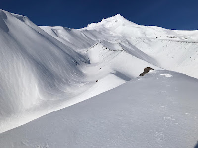
The climb to Puppy Dog View point was so much easier with microspikes. The deeper snow was gone (from last time) and it even got a bit rocky. I tried to avoid stepping on larger rocks. The traverse and final approach was pretty windy and cold. I just kept going, only glancing up occasionally to check my progress. Soon I was rounding a corner and seeing amazing views as the fog had cleared.

Somewhere before I'd seen a pair of sunglasses on the ground. I picked them up and hung them from my pocket so the owner might see them and I could return them.

I passed a pair of hikers and they both were wearing sunglasses. The sunlight and white snow everywhere was tough on the eyes, so I put on the sunglasses. I passed another guy who gave me a double-take but didn't say anything. I had feeling they were his but maybe not. For all I knew, the owner had been one of the many I'd seen on my ascent.

I spent a little time at the top.. I cruised through the trees to try to find the highest spot but without my map, I couldn't be sure. I turned around when I came to two divergent set of tracks. I returned to the trail and took a short break under a tree.

The descent was easy with the microspikes. Where the More Difficult trail splits off, I saw that guy again. He came up to me and asked if I'd seen any sunglasses (the ones I was wearing??). I knew right away and took the glasses and handed them to him. I said was I glad to find the owner but in my mind I was thinking "finders, keepers". I mentioned I was going to take the alternate route back down and we started down the trail.

He was in front and was struggling with just hiking boots. After a couple of slips and one fall, he stopped to put on his microspikes. I stopped to chat but when he said "you don't have to wait" I didn't hesitate. I said "cheers, see ya down below" and took off.

At one point, I was feeling unsure and hoped I wasn't lost. The trail was pretty obvious but there were some spots that weren't. I took comfort in knowing there was another hiker on the descent. When I passed a few hikers, I knew I was where I should be.

When I reached the trail split, I finally took off my microspikes.

I passed a few more hikers coming up the first set of switchbacks and made it back to the trailhead.

I saw the sunglasses guy while I was changing footwear. I tried to wave but he wasn't looking.

Friday, January 28, 2022

Story Time: A Ramble from Myanmar (Burma) to Northern UK


Google Earth map

While browsing the interwebs, I stumbled onto to a post pondering about the lifelong impact a brief encounter can last. The account by Gordon Bonnet about a chance meeting while traveling through a little village near Hadrian's Wall absolutely blew me away. 

A couple in their 60s (sexagenarians) "walked home" from Burma to Northern UK. The 6,660+ mile trek took the couple "a little over 3 years."

The waypoints: Myanmar (Burma) > Bangladesh > India > Nepal > Pakistan > Afghanistan > Middle East > Turkey > Greece > Italy > France > UK.

The Story

Have you ever met someone only for 2-3 days but remembered them your whole life?

Gordon Bonnet, works at Writers and Authors

Yes, and it wasn't even two or three days, it was more like twenty minutes.

When I was in my 30s I did a solo hiking trip across England, from the Irish Sea to the North Sea. When I was in a little village near Hadrian's Wall I saw an old lady, maybe 75 years old, walking toward me. She looked like she could have stepped right out of an Agatha Christie novel - pastel dress, sensible shoes, a hat with a bow, even a parasol to keep the sun off.

As she passed me, she gave me a smile and said, "Are you out for a ramble?"

I told her about the hiking trip I was on.

Her smile broadened, and she said, "Oh, lovely! I do so love a nice ramble. You know, my husband was in the foreign service, and when he retired, we walked home from Burma."

I stared at her, thinking I must have misheard her. Or, perhaps, there was a town ten miles away named "Burma." She must have noticed my astonishment, because she continued to explain. "You see, we were stationed in Rangoon, and when he retired, we had nowhere we had to be. So we decided to walk home. We crossed into Bangladesh, and then into India, trekked up into Nepal and across the northern parts of Pakistan. We were fortunate, because having been in the foreign service for decades, we knew people all through the region – they were all former British colonies, of course.

"We did take a light plane across Afghanistan, which was a bit dicey even back then. But we had a lovely time crossing up through the Middle East, then into Turkey. We crossed the Bosporus on a ferry, then went through Greece and into northern Italy, crossed the Alps into France, and when we got to the Channel we took the ferry across that, too. And presto, we were home!"

Presto indeed. I asked her how long it took them.

"Oh, a little over three years, I think.” She laughed. “We weren't really keeping track very well, I'm afraid."

And, as it turned out, she and her husband did all this when they were in their upper 60s. I'll never forget that experience - talking with the little old lady who bested my hiking experience in the sweetest, most understated fashion possible... the little old lady who "walked home from Burma."

Thoughts

Having just turned 50 last month and dealing with health issues, it can seem like adventures like this are for "younger" people who have the freedom from things anchoring them to a place, their fitness & health. I fortunate to have accumulated material things but when I'm feeling down and/or the wanderlust is high, I turn to the picture of my travels, to try to relive, in some way, my own adventures. 

That time I stayed late at work to get a release out before deadline is meaningless, even in the moment, really. That time I almost missed the Tau ferry in Stavanger, Norway and my hike to Preikestolen was in jeopardy, is indelibly etched in my mind.

This woman's account reminds me of a family story. My great- aunt and uncle were already in their 60s when I was born. When I heard the story, I'd been a skier and had hiked in Canada for almost two weeks. They lived in a rural town in southern California and had a quiet, retired life. It was hard to imagine them being adventurers. 

Sometime when they were in their 30s-50s, they'd set out in the Sierra Nevadas with some mules and horses to explore the back country for a few weeks. (I need to get some clarification on the details to make sure I'm not embellishing. The story is amazing as is.) Wow!

This seemed so badass to me but then again, think of the people that headed out West, and their hardiness and mettle. I regret not having the maturity and introspection to hear the story firsthand. It's humbling and also motivates me to be more adventurous.

Saturday, January 22, 2022

Hike: Hamilton Mountain Loop, N Bonneville, WA

Footpath App route map

Getting There:

Take WA-14 from Vancouver, WA east toward N Bonneville. Just after Doetsch Ranch you'll see the Ranger Station on the north side of the road just before the Beacon Rock parking lot, then another road across from the bathrooms. The road winds up the hill for a bit.

For the first time since I started hiking here, the upper parking lot was open. I remember going up there years ago (10+) when I had my truck. There was just one spot available.

The Hike:

Distance: 8.15 miles
Elevation Gain: 2,142 feet
Number of Steps: 22,627 (Fitbit)
Zone Mins: 110 (68 fat burn, 42 cardio/peak)
Floors: 259
Calories: 3,625

Since I was parked in the upper lot, I started my hike by heading through the campground to the Hadley Grove trail. I briefly stopped at the plaque and touched the petrified wood. 

There were quite a few people out but it didn't feel crowded. As expected, many folks only went to Rodney & Hardy Falls or the lookout below Little Hamilton. There were a pair of hikers with a dog that was a few hundred feet behind me. It was good motivation to keep truckin'. I was feeling pretty tired throughout but found the energy to keep putting one foot in front of the other. Counting the 14 turns at the top really helps.

The place were I turned around (between turns 12,13,14) was easily passable. The snow on the trail was post-holed but had hardened and was easy to walk over, plenty of footprints to follow. 

When I reached top, there was a guy resting and the pair with the dog arrived. I pondered heading to the Saddle. I noticed a hiker making their way. It seemed like they were going toward the summit (opposite direction). I sat down and put on my micro-spikes. FINALLY! This was the first time I'd worn them. 

They worked perfectly (surprise, surprise!). I stepped down the icy trail with confidence. I took my time to pick a good line through the obstacles and post holes. I loved 'em. There were a few spot where I was walking on mud and rocks but I could see there were more patches of ice/snow. I didn't want to damage the spikes.

When I descended the zag, I dropped below the snow line. I easily slipped off the spikes and secured them to my pack waist strap to save time.

The Saddle had a bit of snow but was mostly barren. A couple of hikers and a dog were enjoying the sunny views on the other side. 

The trip back to down was pretty standard but there were lots of downed trees. The Parks crew is going to have some work to do to make the Equestrian Trail passable with a vehicle.

When I reached stairs by Rodney Falls there was a hiker with a cat in a special backpack. I'd seen them earlier. The way they were standing it looked like they were waiting for someone to come up. For a split second I thought I was "jumping the line". I asked this person but they were wearing headphones. After fumbling with their phone and had finally removed one headphone to ask "What??". I sheepishly admitted it was a dumb question and tried to explain. Unfortunately, I only confused the issue with my "clarification" and just said "sorry" and took off down the stairs. Welp. This time, there was someone coming up but they graciously stepped to the side so we could pass with some social distance.

I took the Hadley Grove Trail again and stopped at Little Beacon. The photos below are from that area. The lighting was amazing. I started back and cleared the lookout for a group of 4 that had climbed up there.

West view from Little Beacon

South view from Little Beacon at Beacon Rock

Northwest view through trees from Little Beacon

Hardy Creek crossing at the Equestrian Trail

Another west view from Little Beacon


Thursday, January 20, 2022

Book: "In the Blast Zone: Catastrophe and Renewal on Mount St. Helens"


While daydreaming about my next trip to and around Mt St Helens, I’ve been reading this book. It’s a “collection of poetry and essays” that emerged “from a July 2005 camping trip and educational event at MSH […] that brought together many of the leading writers and ecologists of the American West.”

The “novelists, ecologists, poets, natural historians, philosophers, and geologists” who participated in the 2005 foray included:
- Photographer Gary Braasch, (link)
- Author John Calderazzo, (link)
- Writer & calligrapher Christine Colasurdo, (link)
- Research ecologist Charlie Crisafulli, (link)
- Author John Daniel, (link)
- Research scientist Jerry Franklin, (link)
- Poet Charles Goodrich, (link)
- Professor of ecology Robin Wall Kimmerer, (link)
- Author Ursula K. Le Guin, (link)
- Poet Tim McNulty, (link)
- Author Kathleen Dean Moore, (link)
- Forestry researcher Nalini Nadkarni, (link)
- Naturalist Robert Michael Pyle, (link)
- Professor of English Scott Russell Sanders, (link)
- Aquatic scientist Jim Sedell, (link)
- Author Gary Snyder, (link)
- Author Kim Stafford, (link)
- Lover of volcanoes and writer Fred Swanson, (link)
- Researcher and ecology professor Tony Vogt, (link)
- Writer, artist, and naturalist Ann Zwinger, (link)
- Naturalist and writer Susan Zwinger, (link)

Of all the essays, the chapter by James Sedell resonated with how I'm feeling personally, at this point in time:

"In an article on MacArthur's work, Stephen Fretwell wrote, 'In all research reporting, over-attention to detail can obscure the spirit of curiosity and wonder upon which good, basic research depends. MacArthur's work ... makes inexcusable the report that is deadly dull, but otherwise correct. Better to spend (as MacArthur did) one's time and energy being interesting; if something has to be sacrificed, let it be exactness. Clearly, one can contribute as much with such an approach.' I paraphrased this as a guiding mantra for scientific research: What is the storyline?" Pg. 86
“Going to the volcano with those writers and scientists and other volcano friends helped me reconnect with my own sense of purpose—to share the passion I feel for science […]! I thank Mount St. Helens for stepping into my life at key junctures to bring this purpose and passion into sharp focus.” Pg. 89

While some of the essays are written by scientists and go into some detail about the species of flora and fauna that inhibited the "blast zone" before and after the 1980 eruptions, is the essays and poems about how the writers felt about the area, describing a "loss" and "destruction", many are quick to point out that this "negative" terminology is not accurate in fact and sentiment. 

The writers challenge with their own assumptions & first impressions and are learning to see the "event" and changes after as allegory for recovery, resiliency, and finding purpose when it's not obvious, informing how we can better react to big changes.

“A man turning sixty may lose perspective on time, seeing all change as loss, counting his aches as if they were worry beads, anticipating the chill wind of his last hour instead of breathing in the present moment. And so, to regain his grip on time, to console himself for loss, and to remind himself of the great story in which he is taking part, he may consult with rocks.” - from “Two Stones” by Scott Russell Sanders, Pg. 92

---

IG Post about the book (original text for this post): https://www.instagram.com/p/CY7JT16PzJC/

Saturday, January 15, 2022

Hike: North End of Forest Park 15, Portland, OR

Footpath maps

Getting There

Take NW Skyline Blvd north from NW Germantown Road. The Skyline Blvd Trailhead is 1.6 mi and a parking are available on right (east) side of the road.  

Granted it was a Saturday, I was still a bit surprised to find all the usual trailheads on Germantown Road and NW Skyline. There were more cars/people in Dec and Jan than I saw in the fall. Perhaps, folks are staying a little closer to home for their outings. It could be that I was often hiking midweek.

The Hike

Distance: 7.64 miles
Elevation Gain: 1,761 feet
Moving time: 2:38:17
Total time: 2:38:17
Avg. pace: 23:51
Calories: 1,395 (AllTrails), 3,196 (Fitbit)
Steps: 17,1881 (Fitbit)
Zone Minutes: 100 (78 fat burn, 22 cardio/peak) (Fitbit)
Floors
: 210 (Fitbit) 

This was my first "dirt" hike of 2022. The first outing was a snowshoeing "hike" at White River Sno Park.

Given all the cars I saw at the trailheads, I didn't see that many hikers out on the trails. I maybe passed a dozen hikers. It's one of the reasons I love this end of Forest Park.

Every time I go out for a hike, my mood is almost always better for it. I've been pretty sedentary since after Christmas. Basically, I got very little exercise between Dec 22nd (last Hamilton hike in 2021) and Jan 9th (1st outing of 2022). I know I'm in pretty good shape and have dropped enough weight to put me in the "Healthy" BMI category, though probably more from low appetite thus lower caloric intake, than proper diet & exercise.

I still have doubts about my physical abilities, regardless of how long it's been since my previous hike. I've been trying to maintain some flexibility of lower limbs (mostly knees) and working on upper body strength with weights.

As far as the hike and trail conditions: It's still pretty muddy out here on the Wildwood and some parts of the trail are eroded or damaged from fallen trees. There will be some work in Spring to restore the trail.

This year is off to a tough start, emotionally, spiritually, and physically. I'm starting to see negative effects of my rheumatoid arthritis treatment (methotrexate) and seeing issue with liver and blood. Despite my radical change to diet, quitting booze & cigarettes, and exercise like a mountain goat, I'm wearing down. This hiking is one of the few things that takes my mind off of things yet I'm feeling more and more guilty about my job situation. Fucked if I do, fucked if I don't.

But it doesn't have to be this way. I just am finding it hard to make a difficult choice to turn my world upside down. My recent selection of books has revealed some interesting synchronizations.

Lila - ideas of Quality and being at the leading edge of Dynamic Quality vs static quality, intellectually, socially, biologically.

In the Blast Zone - ideas of destruction or disruption and renewal and hope, rethinking scientific study. Also, how "we" (collective We) can get lost in too much detail, fact, which can lead to "losing the storyline".

Moonbreaker - doing what needs to be done while facing individual struggles, hope despite odds

Thinking in Systems - rethinking how we understand the world and find collaboration between a wide variety of specialties. Also, the quote from Zen and the Art of Motorcycle Maintenance in the preface.

Jr Devs meeting - Zettelkasten and random access/shuffling of ideas, mind mapping used for writing of Lila.

Sunday, January 9, 2022

Snowshoe: White River Snow Park, Government Camp, OR


AllTrails map

Getting There

All it took was the post by Mt Hood Meadows that it was blue bird day at the mountain. After a lame trip up toward Mt St Helens but not actually making it to anywhere good, I wanted to get some exercise.

The conditions on Hwy 26 were good, mostly dry until the straightaway passed Ski Bowl. At 10:30a, there were a lot of cars n trucks. up there. The Ski Bowl parking lot was overflowing and there was a horrendous line going up to the Timberline. I considered stopping at Trillium Lake but that parking lot was super park and overflowing too. 

Next up: White River Sno-Park, an old favorite. The overflow parking lot was not plowed and the middle of the main parking lot was not plowed either. I managed to eek out a spot in the lot north of the bridge (Barlow Road).  

The Hike (Snowshoe)

Length: 6.02 mi
Elevation gain: 1,686 ft
Moving time: 2:42:21
Total time: 3:05:41
Avg. pace: 26:58
Calories: 1,264

First hike of 2022!

I hadn't used my gear since last winter but the boots felt nice with my Darn Tough socks. I grabbed my poles but neglected to switch out the baskets. I headed down the road toward main parking and hopped onto the snow. I realized I'd left my phone so no photos and no trail tracking. I considered forging on but also realized my eye wear wasn't right, I need goggles.

I crossed under the bridge because I'd seen some snowshoers. Maybe I could get back to the car this way. The creek was flowing too quickly, I was cut off. I crossed under the bridge again and went back to the car to get the phone and goggles.

I started the trip tracking on AllTrails and started hiking.

I took the trail up as far as possible. I sat on the rock in the photo below, the highest point on this ridge. It's not a marked trail but is the starting point for skiers. Actually there were lots of fresh tracks on the adjacent ridges, true die hards.

On the return trip, I descended through the trees. There was a well-packed trail that made it easy to keep a steady, comfortable pass. I really like these snow shoes because they rarely feel like they're in the way. I don't do anything special with my stride.