Featured Post

2024: My Year in Review

Another trip around the sun! I kept my same hiking goals from previous years: 52 hikes , 365 miles , 84,000 feet . However, I came up short ...

Showing posts with label Sauvie Island. Show all posts

Monday, May 30, 2022

Hike: Wapato Access Greenway, Sauvie Island, Portland, OR


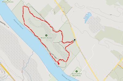
Footpath map

Getting There

Take Hwy 30 to Sauvie Island. Take NW Sauvie Island Road past Reeder Road. The Trailhead/parking lot is 2.3 miles from Cracker Barrel Grocery Store on the left (south side). Be sure to pick up a day pass.

The Hike

Length: 2.53 mi
Elevation gain: 54 ft

This is the third time on this trail; this time I brought my mom. It was Memorial Day weekend and the weather was pretty good after many days of rain.

The northeast side of the loop is in good condition but the straightaway along the Multnomah Channel was pretty muddy. Seems like it's always muddy, reading the trail reports and from experience.

No matter, I had my sandals and just gave up trying to keep clean. My mom was wearing black trainers and got muddy on the sides. When we got to the fishing dock, I washed mine off in the river.

It was good to get outside for a change. The arthritis has been bad so I'm not able to do longer hikes with much elevation. :(

I hope the meds start to work and suppress the inflammation soon!


Friday, March 11, 2022

Hike: Wapato Access Greenway, Sauvie Island, Portland, OR


AllTrails map

Getting There

Take Hwy 30 to Sauvie Island. Take NW Sauvie Island Road past Reeder Road. The Trailhead/parking lot is 2.3 miles from Cracker Barrel Grocery Store on the left (south side). Be sure to pick up a day pass.

The Hike

Length: 2.37 mi
Elevation gain: 52 ft
Moving time: 56:01
Avg. pace: 23:39
Calories: 494
Total time: 1:01:19

Commentary

I debated whether or not to add this "hike" to my list. I guess it qualifies even though it's short and almost no elevation gain. I hiked here last year but didn't record it for my stats.

My arthritis is starting to bother me more and more since having to stop taking the meds. Specifically, my right knee has not stopped hurting since my hike in Forest Park on Feb 17th. I just wanted to keep pushing my body and enjoy some sunshine.

I remember thinking on my Hamilton hike a couple of days before "I'll keep hiking as long as I can with gimpy hand and crumbled body." I know I'm going to have to budget extra time and make preparations for longer hikes and "complications" such as troublesome knee that slows me down a lot.

Ironically, I feel like my knee is strong but the inflammation is causing pain. All the conditioning I've done is paying off in some respect.

The Trail

View from the bird blind

Last time I was here at Wapato, the trail was really muddy. In fact, I hiked in my black Dunlop rubber boots. This time, there was still mud but it was mostly dry and/or easy to get around without stepping in the goo.

There were a lot of garter snakes out there, esp closer to the water. I was out in my sandals but I knew they're mostly harmless. I made sure to stay in the middle of the trail and stomp my feet so they know I'm coming.

Red-spotted Garter Snake (Thamnophis sirtalis concinnus)

There were several folks out there but I didn't see enough to correspond to the cars at the trailhead. Some people were fishing and a guy in a group of four older folks said "Are you waiting for a bus?" because I giving them space & waiting for them to go by.

Because of the snakes and my footwear, I didn't attempt to get views of Multnomah Channel. (I saw a bird of prey last time. Possibly an eagle.) Not this time.

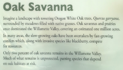
The "inside" part of the loop goes through the Oak Savanna.


Oak Savanna

Oak Savanna

Wapato Access Greenway

Heading Home

A lump grew in my throat when I saw Mt St Helens. I really want to climb it again but the fact that I'm starting a new job and my increase of arthritis symptoms makes it seems unlikely this year.

I renews my anxiety of existential dread. The world is so fucked right now. People in Ukraine are dying every day. Inflation (corporate greed) is threatening the simple ability to survive. Maybe I should have sold my house and try to get in as much traveling as I can while my body still can. When I'm bedridden, it will be a small but significant comfort to recall my hikes and roadtrips. Fuck!

Sunday, May 30, 2021

Hike: The Narrows & Mud Lake, Sauvie Island, OR


Length: 4.14 miles
Elevation Gain: negligible
Type: Out & Back
Steps: 9,064


Getting There

My legs were a bit sore from the hike the day before. It felt good to get out on such a nice day. The Wapato Trail parking lot was full so I keep going. I was just planning to see how far up the road I could get. The gate was closed right after the pavement last time I drove there (a few weeks ago?).

I barely made it to the dirt road because I had to relieve myself. Whew! 

I drove into the park and cruised along. Pretty mellow for a holiday weekend. Good! 

I saw a sign about Rules & Regs near the trap shooting range. I was the only car. I saw two tires tracks disappear around a corner. Looked hike-able. I wondered if it'd get close to the cattle that were grazing. It was a bit weary.

The Hike

I suited up with my boots, poles and snacks. Donned my straw hat and put a layer of sunscreen on my tattooed arms.

I quickly found a marker that said 1-4 this way (with an arrow) and 5-6. I had no idea but I figured it was trail marker.

Some jackass nearby was letting their puppy bark and bark and bark and bark and bark. It was incessant. It was far away but shattered the otherwise peaceful scene. I broke and hollered for them to STFU! I decided to go in the other direction. I was dismayed to find so many shotgun shells on the ground. Fuck heads!

I found the first bird blind. I thought how cool it was but realized it was for killing birds not watching them. It was numbered #5.

As I made my way along the Narrows, I found #4, 3, 2, and finally #1.

I saw some cranes (white ones). Lots of birds but no fowl. 

A family in a canoe stopped briefly at the shore of West Arm/Steelman Lake. 

I had to turn around because the lake had overrun the road. I could have gone to the point but would have gotten my boots wet & muddy.


Sunday, October 4, 2020

Road Trip: Cape Disappointment, WA; St Helens, OR; Warrior Rock, Sauvie Island, OR

This is a five-part, incongruous multi-day trip. First was the hike to Warrior Rock Lighthouse on Sauvie Island. Next was the trip to St Helens, OR to see the bell. Then, this long day trip to the coast to Cape Disappointment. Most recently, I took another trip to St Helens, OR to see the 1/2 scale replica of the Warrior Rock Lighthouse and the bell again. I'm not currently scheduled to go but the 5th part will be a trip to West Point Light in Seattle.

Photographed: Oct 3, 2020

 The Life of a Bell

Last weekend I hiked/walked to the Warrior Rock Lighthouse on Sauvie Island. The current lighthouse doesn't look like much; a small concrete structure with mediocre graffiti art around the base. After a quick internet search, I found it had an interesting history going back to the late 1800s. 

The original Warrior Rock Lighthouse was built in 1889 and "had living quarters below and an oil lamp beacon light with lens and a hand-cranked fog bell on top."

"The fog bell was cast in 1855 at the J. Bernhard & Co. foundry in Philadelphia was originally installed at the Cape Disappointment Light at the mouth of the Columbia River" (1856) and later at the West Point Light in Seattle (1881).

In 1969 A barge hit the Warrior Rock Lighthouse "destroying the foundation and disabling the light and bell" The bell was further damaged during removal, "putting it out of commission". "It is now outside the Columbia County Courthouse in St. Helens."

Source: https://en.wikipedia.org/wiki/Warrior_Rock_Light

The Drive

As per usual, I don't always have a solid plan when I go out exploring. I actually drove south toward downtown and fueled up at the gas station by Broadway Toyota. Then, hopped on I-5 north and zoomed passed Columbia Blvd.

When I reached Woodland, I considered exploring around Mt St Helens. The air was not good for hiking, for example a trip to Norway Pass, so that was out.

By Kalama I'd decided a visit to Cape Disappointment & Long Beach via Hwy 4. 

It was a pretty chill drive, not much traffic heading west. 

Cathlamet is a crossing point via ferry to Oregon to Hwy 30. It seemed like a good spot to stretch the legs and snap a couple of photos. While not totally obvious in the photos, you could see the brown haze over the Portland area in the distance.

Cathlamet (southeast view), Julia Butler Hansen Bridge (WA-409)

Cathlamet (southwest view), Columbia River/Ryan Island

It was good to reach the coast finally. I cruised up the Long Beach peninsula but chose not to get anything to eat. It was a little ways south on Hwy 101 to Ilwaco and the lighthouse (Cape Disappointment and North Head).

View from Beard's Hollow View Point

I'd been to the North Head lighthouse a few times but not sure if I've been to Cape Disappointment. I don't think I realized there were two lighthouses in this area. 

Cape Disappointment Lighthouse

The Cape Disappointment Lighthouse is closed due to the pandemic but the Battery Harvey Allen @ Fort Canby are open. There is a trail to the lighthouse from the Battery/Fort parking lot but it's closed as well.

It's similar to the Battery at Fort Stevens.

Trail from Fort Canby parking lot

Battery Harvey Allen

Battery Harvey Allen

Battery Harvey Allen

Battery Harvey Allen

Battery Harvey Allen (sacrifice pit) :)

Outside the Lewis & Clark Interpretive Center at Cape Disappointment is closed due to the pandemic but the views from the grounds are amazing. The Center sits on top of the Battery.

Lewis & Clark Interpretive Center
Ocean view


Selfie among the snakes

Return home

I messed up and didn't check out the jetty. I mistook the park entrance as just gate for the campground. I bet my Discovery Pass would have been enough for entry, if anyone was even in the booth. It was about 5 pm and I still had a 90 min drive back home. I drove through Ilwaco and south on Hwy 101 to the Astoria-Megler Bridge then returned back to Portland via Hwy 30.

Monday, September 28, 2020

Hike: Warrior Rock Lighthouse Trail, St Helens, OR

Getting There:

From Hwy 30, cross the bridge to Sauvie Island and head north passed the store. Turn right onto NW Reeder Rd and take it all the way to the end. Just before the beaches, the road turns to dirt. There are big sections of washboarding.

A parking permit is required on the island: https://sauvieisland.org/visitor-information/park-permits/

The Hike:

Length: 6.5 miles round trip
Elevation Gain: 42 feet
Type: Out & Back
Duration: 2 hours  

This is an easy hike. I'm surprised that AllTrails shows any elevation change. There is one fallen tree that you have to go around and a couple others that you can walk through single file. Otherwise, the trail is wide and was apparently used as an access road to the lighthouse in the past. 

You cannot climb on or inside the lighthouse. It's not the kind with a Fresnel lens, but cool landmark to see.


"Warrior Rock Light is a lighthouse on Sauvie Island in the U.S. state of Oregon, which helps guide river traffic on the Columbia River around the Portland, Oregon area. It once contained the Pacific Northwest's oldest fog bell. It is Oregon's smallest lighthouse, and the only lighthouse, or one of only two lighthouses, still operating in Oregon which are not on the Pacific Ocean, depending on whether the Umpqua River Lighthouse is considered to be on the coast or on the Umpqua River."

Source: https://en.wikipedia.org/wiki/Warrior_Rock_Light

Some more views from the point: 


Difficult to see, Mt St Helens is peeking over the horizon, right of center (photo below). She is pretty barren of snow at the moment.