
Showing posts with label Glacier Overlook. Show all posts

Sunday, August 3, 2025

Hike: Glacier Overlook @ Mt St Helens, WA


Getting There

I drove from Portland to Randle, then dropped down on NF-25 but had to take a detour passed Cispus Learning Center via NF-76, reconnecting with NF-25 at Iron Creek Campground. Then, continued south to Wakepish Picnic Area & Sno-Park, at the junction for NF-99. I was technically "camping" but I just slept in the back of my Jeep. It was good to have access to the brand new pit toilet there. 

In the morning of the hike, I drove about 16 miles to the Windy Ridge parking lot to meet the guides, fellow volunteer, and guests.  


The Hike

Distance: 6.77 miles
Elevation Gain: 1,760 feet
Max. Elevation: 5,277 feet 

Note: This isn't the actual hike route. We are accessing an area that is off-limits to the general public through special permission from the USFS & the Cowlitz Tribe, I didn't want to make the actual route public. This is just the AllTrails map for Loowit Falls, which IS open to the public.

Additionally, we had access to the trail from the staging site for the Spirit Lake tunnel project road.


This was my second GO hike in 2025. We got word a few days before that the geologist that was scheduled to be on this hike had canceled. The guests would be getting a partial refund. The guide, other volunteer, and I would have to fill in the gaps. I might not be a geologist but know enough about the mountain and eruptive history to share some facts with confidence.

Our group was great. 3 sets of couples were one group from Vancouver, WA and another pair of women that were traveling from Chicago in a Sprinter van. They were unfazed by the lack of the geologist. 

We started out strong but part way up the pumice plain, one lady from the "roadtrippers" and one from the group of 6 weren't doing well and decided to hang back. The other MSHI volunteer stayed with them and I continued with the guide and rest of the group. 


The place where we've had lunch before had degraded since the previous year and was unstable. The weather was great: a few in the group we wearing shorts and short-sleeved shirts.


We started back down to the main trail. The crew seemed contented with the views and we didn't venture any further, like to Loowit Falls. We reconnected with the splinter group and eastbound back to the cars at the trailhead.


Sunday, July 13, 2025

Hike: Glacier Overlook @ Mt St Helens, WA


Getting There

I drove from Portland to Randle, then dropped down on NF-25 but had to take a detour passed Cispus Learning Center via NF-76, reconnecting with NF-25 at Iron Creek Campground. Then, continued south to NF-99. I continued north towards Windy Ridge and Cascade Peaks Interpretive Center. The MSHI Field Camp is down NF-380 & NF-2560 about 2.3 miles. It took a few minutes but I figured out the mult-lock gate and started down the road.

This part of the drive gave me a lot of anxiety. This is where I had my first bout of vertigo while driving to field camp last summer. I didn't find the exact location where I had to pull over but was relieved when I got the my destination.

Overnight, it was quite windy. I had some trouble getting my rain fly secured due to the rocky ground. I was making a lot of noise, whipping around. I figured it was just how it was going to be but around 1am or 2am, the rain fly had to go, it wasn't needed anyway. I got up and removed it. Peace and quiet at last. Except the moon was so bright! LOL.

In the morning of the hike, I packed up camp and had some breakfast with the group. As was getting ready to go, one the guides who was camped about 15 feet away made a comment about the rain fly. 

I offered a weak apology. Oops. My bad. I hopped in my car and drove about 8 miles to the Windy Ridge parking lot to carpool with fellow volunteers and guides/staff. 

The Hike

Distance: 6.77 miles
Elevation Gain: 1,760 feet
Max. Elevation: 5,277 feet 

Note: This isn't the actual hike route. We are accessing an area that is off-limits to the general public through special permission from the USFS & the Cowlitz Tribe, I didn't want to make the actual route public. This is just the AllTrails map for Loowit Falls, which IS open to the public.

Additionally, we had access to the trail from the staging site for the Spirit Lake tunnel project road.


At the trailhead and Spirit Lake Tunnel staging area, we got our gear together and head out on the trail. The weather was great, clear skies and dry. 

When we got to the point of the hike were we started off trail, one volunteer wasn't feeling up to it. One of the climbing guides said he would hang back with them while the rest of the group continued to the overlook.

I was wearing my halter monitor but didn't tell anyone. It was good to do a "stress" test. I was worried about not being able to do this hike due to vertigo and palpitations. I felt a burst of confidence that I was in good shape. Not to shame the person that had to hang back (schadenfreude)

We saw a couple dozen mountain goats, many of the adults still had most of their winter coats and it was mid-summer. Not sure if people from the Cowlitz had collected the fur but we didn't see much on the bushes. 


The glacier appeared to have advanced north (towards us) since the previous year. It is still 60/40 snow to rock but you see the leading edge because of the darker dirt/pumice (wet).


On our way back to the trailhead, I didn't take many photos but did catch a couple shots of the wildflowers: a lot of Indian paintbrush (reddish) and prairie lupine (purple). 

In our "roses & thorns" debrief, many acknowledged how cool it was to hike in a big group with fellow MSHI volunteers, since we normally rove solo or in pairs.

Saturday, August 24, 2024

Hike: Glacier Overlook @ Mt St Helens, WA


Getting There

I drove from Portland to Randle, then dropped down on NF-25 to Wakepish Picnic Area & Sno-Park, at the junction for NF-99. I was technically "camping" but I just slept in the back of my Jeep. It was good to have access to the pit toilet there. 

In the morning of the hike, I drove about 16 miles to the Windy Ridge parking lot to meet the guides, fellow volunteer, and guests. 

The clouds/fog filled the valleys to the east so I had to stop to snap a couple of pics.

After a short talk in the little amphitheater, we carpooled to the trailhead, about 2 miles. (Funny to pass hikers, mostly on the way out, who look surprised and wonder why we got to drive beyond the gate.)

The Hike

Distance: 6.77 miles
Elevation Gain: 1,760 feet
Max. Elevation: 5,277 feet

Note: This isn't the actual hike route. We are accessing an area that is off-limits to the general public through special permission from the USFS & the Cowlitz Tribe, I didn't want to make the actual route public. This is just the AllTrails map for Loowit Falls, which IS open to the public.

Additionally, we had access to the trail from the staging site for the Spirit Lake tunnel project road.


This was my third trip to the Glacier Overlook. I'd first been here in mid-July for the training hike with all the volunteers, guides, and some staff. I came back as a "paying" guest on at the beginning of August. This time I was supporting the guides as an MSHI volunteer. Plus, I'd hoped to get a third picture of the crater & domes for comparison.


While everyone was getting their gear ready for the hike, we spotted a herd of elk traversing the lower flank of the mountain, somewhere between Sugar Bowl dome, a nearly circular protrusion of hypersthene-hornblende dacite, and Windy Pass on the Loowit Trail.

Elk herd (middle right of the image)

Everyone was in good spirits and glad to be out on the Pumice Plain, despite the limited visibility of the mountain or Mt Margaret backcountry. We hiked to the closest point the the glacier for this hike. I turned around and snapped a pic of ravine were Loowit Falls is located. Incidentally, on the right is an old helicopter landing pad. What's left are some concrete posts to secure the aircraft in high winds.

Near where we had lunch, we spotted this pumice "bomb", a chunk of pyroclastic debris ejected from the volcano. It look a bit like Dutch crunch bread or tiger bread. I was cooling and cracking on the outside but still molten on the inside. We found other other rocks that were similar but completely shattered.

The next four pictures are various angles of the crater and zoom levels. It looked like the recent rains had washed some of the dirt and rocks from the leading edge of the glacier. It's about 60% ice, 40% rock. We caught a glimpse of the rim but it quickly disappeared behind the clouds/fog.


After lunch and a short talk by the guides, we headed back down to the Loowit Trail. The fog/clouds were hanging just above Spirit Lake. When we got down to the official trail, we took a poll to see if we had consensus to take a side trip to Loowit Falls. I'd never been that far west on the Loowit Trail and was happy for the bonus trek.

The falls is about 0.7 miles from where we were. You can see it once you make the 'turn' from the Loowit Trail.


One more look at Spirit Lake as we started heading back to the cars.


Sunday, August 4, 2024

Hike: Glacier Overlook @ Mt St Helens, WA


Getting There

This was my second GOH, but this time as guest, patron. Since field camp wasn't offered or an option, I chose to camp somewhere just outside the monument. I checked nearby campgrounds like Tower Rock (near Cispus Learning Center) and Iron Creek but neither had availability. I didn't want to stay as far away as Packwood, nor foot the bill for a room.

Since I'd missed the WTA/MSHI Jamboree, I decided on Wakepish Picnic Area. I drove to the gate on NF-25 to take a look and scout for a spot off the road. None appealed to me and I didn't want to use a cat hole. When I pulled into Wakepish, there were a few cars but I didn't see or hear any people. I wasn't going to make much a footprint and decided against setting up a tent I'd have to breakdown in the morning. What if a ranger had asked folks to move along in the middle of the night since this wasn't officially a campground?

I made my cocoon in the back of the Jeep. A guy with a dog eventually pulled up next to me, about 20 feet away. I ignored him and kept rearranging my gear for the night. I cautiously approached and asked if I minded him being there next to me. What was I supposed to say? I said "of course. no worries". He made some comment about his dog being friendly and would likely come to visit me at some point. Fine, I thought.

I could have been more social and I almost took him a copy of the Volcano Review but thought it would invite more conversation than I wanted to engage in. I took off my MSHI hat to keep a lower profile.

I sat outside to read until there wasn't enough natural light. I climbed into my truck and got comfy.

The next morning, I put my sleeping bag, pad, pillows away and un-built the cocoon. I took off for Windy Ridge to rendezvous with the group.

We had our pre-hike orientation talk at the little amphitheater, then carpooled down to the trailhead. There were only 4 other paying guests. Two friends rode in my car. The guides, MSHI volunteer, and other two guests took three other cars to the road construction site on the Truman Trail.

The Hike

Distance: 6.77 miles
Elevation Gain: 1,760 feet
Max. Elevation: 5,277 feet

Note: This isn't the actual hike route. We are accessing an area that is off-limits to the general public through special permission from the USFS & the Cowlitz Tribe, I didn't want to make the actual route public. This is just the AllTrails map for Loowit Falls, which IS open to the public.

Additionally, we had access to the trail from the staging site for the Spirit Lake tunnel project road.
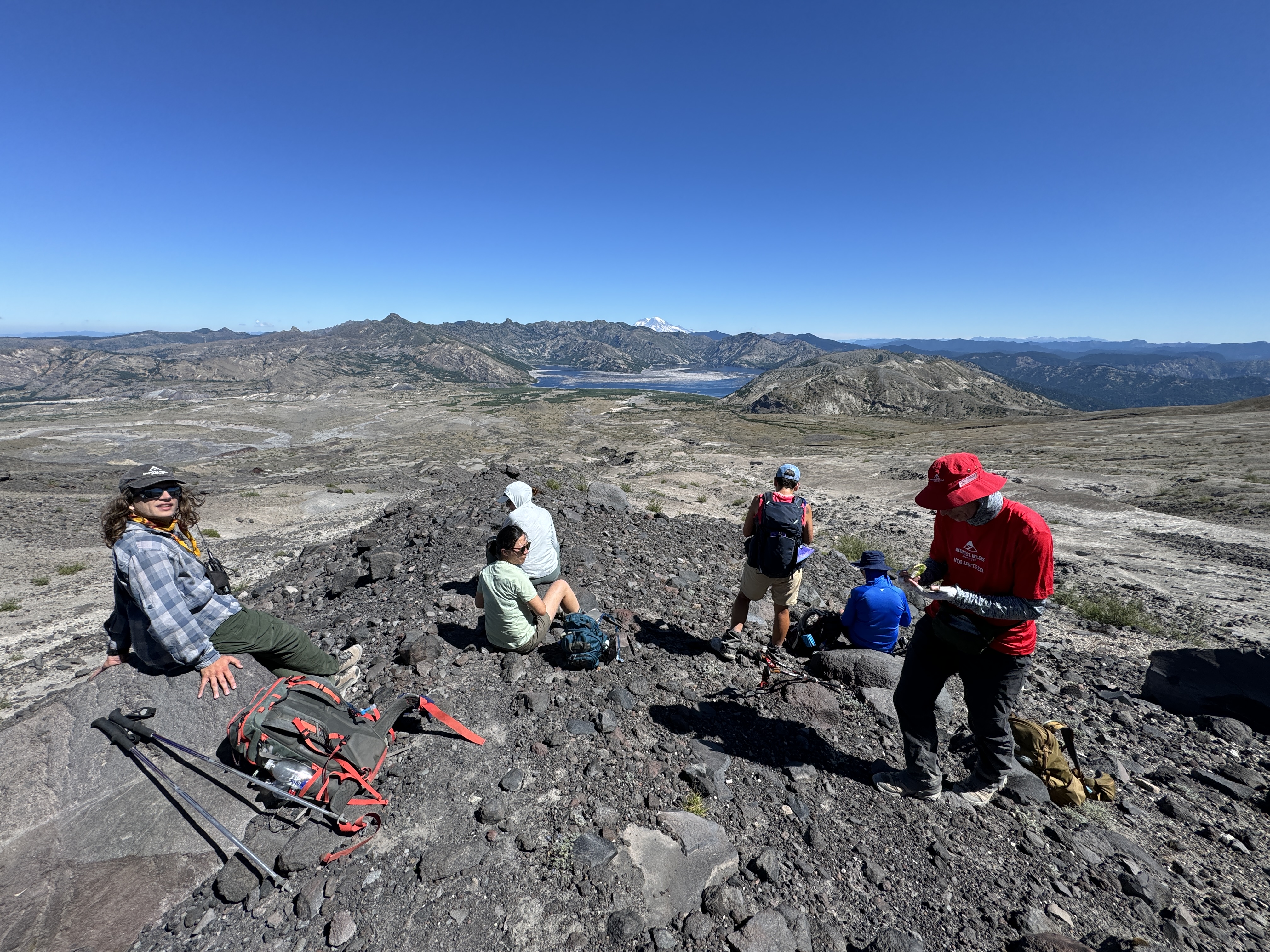

The group was really chill. We stopped a few times along the way for some interpretation about the 1980 eruption, the geology and landscape before and after the eruption, the cultural significance of the mountain to the Cowlitz tribe and other indigenous people that used to visit this area.

We didn't see any mountain goats like we did on the Training hike in July. We did see bits of their fur which was know is collected periodically by local Cowlitz people.

 It was hot but not oppressively. My sunshirt was perfect to keep me shaded, protected from UV rays, and still allow the breeze to filter through the fabric. The views were incredible!

So fortunate to be able to visit this special place that few have seen and been to. The hike was confidence building on several levels. To be able to support guide team as a 2nd year MSHI volunteer and reaffirm my physical fitness following the bout with vertigo just a few weeks before.

As with the train hike, we did our round table "roses & thorns" (or peaks n valleys). Basically, the high and low points of the day. Unanimously, folks only gave their high points (roses/peaks) and offered low points (thorns/valleys) as straw men. Probably, for decorum, in public-group setting, but also genuinely that we had great crew, small, and there were no hitches.

We drove back to Windy Ridge and went our separate ways. A good day.

2004-2008 dome in the foreground


Mt Rainier & Spirit Lake

Break time, mid-hike

Approaching the glacier overlook

Mountain Goats in the distance

Lunchtime

Mt Adams

Windy Pass