|
| AllTrails map (mobile) |
Getting There
Tuesday, Dec 14 was my birthday and I knew I wanted to hike somewhere. I got a bit later start than I wanted but then again, what’s the rush? (More on that later).
I had my snow shoes so I thought I’d hit Trillium Lake, White River, or even Mirror Lake. I knew when I passed Exit 16 that I wasn’t going via Hwy 26. I thought I’d take the long way through Hood River.
On my way, I reconsidered and thought “the weather is good down here, how about staying in the Gorge?”. I took the Ainsworth exit and followed the frontage road to the trailhead. Welp, all but one trail was closed due to fire damage, erosion control.
The pulled back on the highway and kept on trucking’. It was cool to see Cape Horn, Archer, Hardy Ridge, Hamilton, Table from across the river.
I drove passed Cascade Locks and pulled into another trailhead. The ____ just follows the freeway unfortunately, too much noise!. I snapped a couple photos and bailed.
As a got close to Hood River, Wind And Dog Mountains caught my eye. I drove to HR and crossed over to WA. I made my way back west to the Dog Mountain trailhead parking lot. Only a few cars were there so I parked and geared up. (I’d only ever seen the place packed with cars and signs about needing a ticket during peak summer months.)
The Hike
Elevation gain: 2,438 ft
Moving time: 2:21:16
Total time: 2:30:26
Calories: 1,245
The trail was great, a lot like Hamilton, wide and well groomed. It’s definitely a leg burner (2500’ in 3mi) but there are some nice breaks in the upper forest.
The first viewpoint was worth it. I took a couple selfies and sent them to my mom and two aunts.
When I got to the trail split (more difficult vs difficult), I chose the easier of the two.
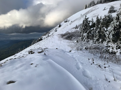
At 2000’ where the two trails rejoin the trail was steeper and icy. I thought about the difficulty coming back down without micro spikes. I continued despite.
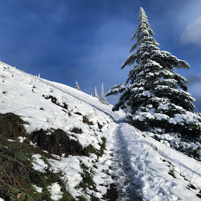
Eventually the ice was replaced by nice hard pack snow. This ended at Puppy Dog Viewpoint. Obviously most folks were turning around here.
Beyond were ankle deep foot holes. I didn’t have gaiters or micro spikes. And since I’d gotten a later start it was 3p, the time I’d decided to head down lest I run out of daylight.
Going to the top would likely have added 45min-1hr.
I vowed to return soon, with the proper gear. Soon!!!!!
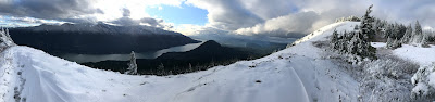
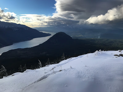
Looking at the last 1/2 mile (but turned around) The final straight-away to Puppy Dog Viewpoint Pano from above Puppy Dog Viewpoint Looking west at Columbia River Gorge + Wind Mountain