 |
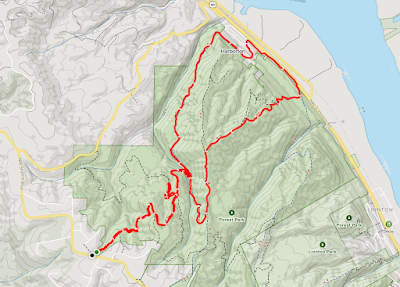
| AllTrails map |
Getting There
Take
NW
Skyline Blvd north from NW Germantown Road. The Skyline Blvd Trailhead
is 1.6 mi and a parking are available on right (east) side of the road.
I parked, geared up and set out.
The Hike
Distance: 6.96 mi
Elevation Gain: 1,650 ft
Moving Time: 2:16:41
Total Time: 2:21:01
Avg Pace: 19:39
Calories: 1,204
Type: Loop (except section to trailhead)
This is the 11th time I've hiked this section of the park but I tried a new route this time.
I did the first segment to the Firelane 12-15-Wildwood and I took Firelane 12 all the way down to Hwy 30. Actually, the trail ends in the neighborhood of Harborton (NW Creston Road & NW Harborton Drive.)
Then, I traversed along Hwy 30 (noisy) but I saw some interesting trash like love notes on heart-shaped sheets, like torn for a teenager's notebook.
I considered going up Newton Road but opted to just take the BPA Road up. Using my hiking poles seemed to help, I didn't feel as winded as without. The tiny push I got from each arm helped enough to make a difference.
I stopped for a couple of minutes to talk to a woman with a dog. My time was slower than usual. 3:17-3:46 = 29 min vs the usual 25. Maybe those couple of minutes chatting but I really feel like the poles helped me go faster. Guess not.
I wanted to check out Wildwood to Newberry but it was pretty muddy/mucky out there and I bailed after 0.2mi (0.4mi rt).
I didn't start my hike until about 2:10p so I had limited daylight. It was dark when I reach the St John's Bridge.

