Featured Post

2024: My Year in Review

Another trip around the sun! I kept my same hiking goals from previous years: 52 hikes , 365 miles , 84,000 feet . However, I came up short ...

Thursday, February 27, 2025

Hike: Angel's Rest and Devil's Rest via Wahkeena Creek, Corbett, OR

Getting There

The weather was amazing, the temp were in the upper 50s and blue skies for miles. Recently, it's been pretty rainy so I jumped at the chance to get outdoors.

I took I-84 east and took the exit for Bridal Falls (Angel's Rest, Wahkeena). I knew the Historic Highway 30 was closed between Wahkeena and Multnomah Falls, and has been for a several months so far. I took a gamble that there was an open spot given the limited number of spaces.

All the spots were full (except for the handicap spots). I knew getting to the parking lot for Multnomah Falls was going to be a hassle since there are no eastboard on-ramps at Bridal Veil. I had to wait. I noticed a couple walking back to their car and queued up to take it. Woohoo!

The Hike

Length: 10.22 mi
Elev. gain: 2,900 ft
Moving time: 4:32:21
Avg pace: 26:39
Calories: 2,400
Total time: 4:58:00


This was my longest hike since Smith Rock in Oct 2024 and the most elevation gain since climbing Mt St Helens in Sep 2024, a great accomplishment considering my lingering foot issues and lack of consistent hiking. It felt great to be out there on a favorite trail.

My usual route has been Wahkeena to Devil's Rest and back, or making it a loop by returning to the car via Multnomah Falls. This time, I took the Angel's Rest Trail after passing Fairy Falls. I'd been down this way after leaving Devil's Rest but I'd never hiked all the way to Angel's Rest from this direction.

There were several downed trees that I had to climb over, several I could have cut if I'd brought my saw but a few of huge, like 16-20"+ in diameter.


The approach to Angel's Rest is great: you see the outcrop and a few people enjoying the sunshine and views. I hiked to the loop and went clockwise. I stopped at a spot where I could take off my pack and have a few bites of my sandwich. I had plenty of daylight but I didn't want to push it since the next section of the hike was unknown to me.


I started toward Devil's Rest via some well-marked user trails: Foxglove Way trail to Red Shorts Cut to She Devil. It was a welcome sight to see the familiar destination.

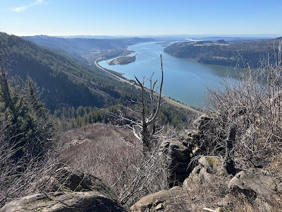
As I continued back to the trailhead, I had a great view of Mt St Helens peaking out.


This photo was edited but when I finally got down to the Wahkeena switchbacks, the sun was going down and colors getting more orange and saturated.


It was a great way to spend the afternoon. I will definitely do this loop again. I loved the distance and EG, and you can hardly beat the views.

Friday, February 21, 2025

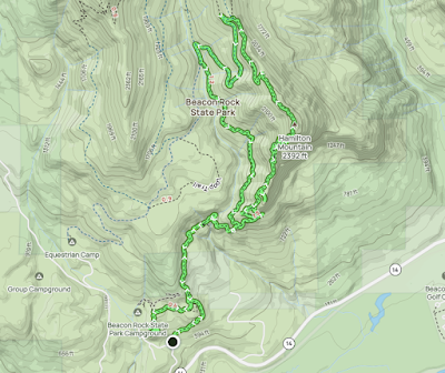
Hike: Hamilton Mountain + Hardy Creek, N Bonneville, WA

Getting There

Just after Doetsch Ranch you'll see the Ranger Station on the north side of the road just before the Beacon Rock parking lot, then another road across from the bathrooms. The road winds up the hill for a bit.

It was early afternoon and the weather was slightly overcast but I expected some nice views from up above. Not too cold, but I was hoping for some snow along the ridge between the top and the Saddle.

The Hike 

Length: 9.32 mi
Elev. gain: 2,487 ft
Moving time: 4:12:52
Avg pace: 27:08
Calories: 2,228
Total time: 4:54:56


I'd been a month since my last hike. I was dealing with a sore toe (ingrown nail, something else?). It was bothering me when I hiked Coyote Wall but fortunately my hiking boots are big enough that it wasn't an issue, esp. on the descent when you might be more likely to rub toes on the front of boot.

Anyway, I was looking for a conditioning hike and knew my favorite trail would deliver. I rarely start this hike thinking I'm going to CRUSH it. It's more "I hope I make it to the top."

As usual, by the time I reach Rodney Falls, I'm pretty well warmed up and ready for the rest of the ascent. This was no exception. I was ready to go. I remember seeing a pair of hikers and a dog (maybe two) leaving the parking lot just before I did.

I saw them again above Rodney Falls. I figured that was their destination and continued on. While taking a brief rest stop on the switchbacks I heard voices and recognized them. I'm not really competitive but the desire to stay ahead of them becomes are motivator.

They never were too far behind but I keep a comfortable lead. Near the top of the upper switchbacks, I found a dead rabbit on the trail. I did my best to move it off the trail but figured I'd try to alert them so the dog wouldn't mess with it.

I waited until they were within shouting distance. All I got for a response was "okay". Sometimes I wonder why I bother. Oh well.

As I reached the top and found a bit of snow. I passed some hikers on their way down wearing microspikes and exchanged the obligatory "you don't need 'em but might as well use 'em". At the top, I fished my own microspikes out of my pack and put them on just as those two guys and the dog were arriving.

I said hello again and started toward the Saddle. 

I stopped there to munch about half of my sandwich and enjoy the quiet and solitude. I need to remember to do that more often on my hikes, even the conditioning ones.

I opted to skip Don's Cutoff this time and took the Equestrian Trail down to the Lower Hardy Creek junction. I stopped there to adjust my boots.

There were a few trees down across the trail but I'd left my folding saw at home. D'oh.


Near the bottom, I did my obligatory side quest to Little Beacon. There was a guy taking photos and told me he'd planned to camp but didn't realize the campground was closed for winter. I climbed up the steep incline to the eagle's nest on top of Little Beacon. I wasn't sure if the guy would follow, and sure enough he did. No matter: I wasn't planning to linger up there.

I pointed to the view and started down but this guy was close to follow. I was going to head to the car but waited for him to leave. I didn't get a creepy vibe but it was like chatting with someone, then saying goodbyes but walking in the same direction. In fact, instead of walking back to the trailhead through the campground, I doubled back to main trail and went that way.

I found a warning on my windshield from a park ranger. I'd posted a NFRP parking pass instead of a Discover Pass. I had to buy a $10 day pass and send proof of purchase to the ranger email. Oops. Sucks that I used the NFRP for nothing (wrote the date on it). 


The ranger that replied to my email was super cool. "Thank you for your quick response, the wrong pass is a simple mistake. Please consider the notice you received void, you will NOT be issued a citation. Thank you for supporting Washington State Parks! Hope you have a good weekend and come back to Beacon Rock again soon."