Getting There
Take WA Hwy 14 out from Washougal.
Take a left (north) at Smith-Cripe Road, about half way between Prindle
and Franz Lake. The High Valley trailhead parking lot is about 0.5mi up the road.
There's room for 10-15 cars if everyone parks responsibly (i.e.
perpendicular or angled).
This time there were 6 cars when I got there so I parked parallel. I geared up and set out.
Note: I thought the day was going to be a bust. My original plan was to hike Eagle Creek or Nesmith Point but I knew it was going to be bad when I saw 1/4 mile traffic jam at Multnomah Falls. I changed plans then to hike on the other side of the river. Indeed, cars lined every nook and cranny at Eagle Creek. Table Mountain Trailhead looked okay but Hamilton Mountain was packed. Archer was the clear choice. I hardly saw anyone on the trail. Peaceful.
The Hike
Length: 5.83 mi
Elev. gain: 2,274 ft
Moving time: 3:27:57
Total time: 4:05:00
Avg pace: 35:39
Calories: 2,093
Cool hike around Archer Mountain. After quite a climb (1000':1 mi) to Scott Point, my first stop was Quiver Point. I didn't quite go to the end but close enough. The next stop was gonna be Arrow Point but when I got to the cutoff, the route looked muddy, steep, and sketchy. Oh well, I'll try again when it's dry. I continued up to the top of Archer Mountain. The foliage was flattened from the winter snow so you could see through the trees to BRSP.
When I got back to the meadow near the trailhead, I still had some energy and it was only ~3:30p. I headed up the other side of the canyon towards the basalt ridge. It was grueling but I made it past the scramble section. I felt a twinge in my L ankle and R knee. I knew the descent was going to be tough so I turned around.
 |
Half way up the trail
|
 |
View from Quiver Point
|
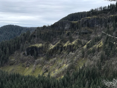 |
View of ridge from Scott Point
|
 |
More from Scott Point
|
 |
| More from Scott Point |
 |
Archer Falls
|
 |
| Trillium |
 |
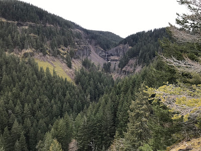
View from ridge
|
 |
View from Scott Point
|


