
 |
| Selfie from Bells Mountain Trail |
 |
| Footpath app view |
 |
| AllTrails view |
Getting There
When I left the house, I was planning on hiking in the Gorge somewhere. My last hike was at Hamilton Mountain so I wanted to switch it up. I thought part of the Cape Horn trail is closed for peregrine nesting but looks like that's only from Feb 1 to July 15th.
Next on my list was either Table Mountain or Dog Mountain. The weather from Portland to Camas was pretty crummy but the skes looked lighter toward Hood River.
On a whim, I made the choice to head to Silver Star Mountain. I figured even if the hiking was a bust I could enjoy a little time driving the forest road to Yacolt.
From Portland, I drove over the Interstate bridge and hopped on WA-14 towards the Gorge. I stopped in Camas to fuel up (petrol, snacks). When I got Washougal, I took the roundabout to to N Washougal River Road. Then, took a left on NE Hughes Road (past Jamie's Dahlias) and followed that for a bit. It changes to NE 392nd, NE 28th, NE Miller, NE 39th. Keep an eye open for Skamania Mines Rd. Take a left on NE 412th and veer right onto Skamania Mines Rd. When the pavement ends, the road becomes L-1200.
When I reached the Grouse Vista and Tarbell Trailheads parking lot on L-1200, there were only a few cars and the weather seemed to get darker, more rainy. I just didn't like the vibe and aborted my hike here. At least I could enjoy some off-roading.
When L-1200 ends, you can go north on NE Dole Valley Road which overlaps NE 312th Ave. A bit farther, it becomes NE Sunset Falls Road.
I was planning to drive through Yacolt but took a left on NE Railroad Ave instead of a right. This took me past Moulton Falls. In the summer, I drove past here a couple of times and the parking lot was always pretty full. I figured it was a day park so just stopped to take some photos. (I was thinking I could head to Forest Park or Sauvie Island.)
The Hike
Length: 4.75 mi
Elevation gain: 1,314 ft
Moving time: 1:40:11
Avg. pace: 22:25
Calories: 1,007
Total time: 1:49:43
Because I was in the overflow parking lot, the trail goes along the road for a little. The area around Moulton Falls is well maintained and there is a lot of nice stonework.
From one spot I noticed the bridge so I continued further to see what was what. I crossed the bridge and started cruising down the East Fork Lewis River Trail. It looks like it parallels the river for awhile; a great place to exercise, wander.. no river access.
A little ways down, I saw the sign for Bells Mountain! Hooray. Looks like I could get some hiking in after all.
I started up the trail without knowing how far I'd go. The sign said Cold Creek Campground was like 8-10 miles; that wasn't in the cards given the time and not knowing the area.
In the end, I got over a 1000 ft of elevation gain and went about 2+ miles up to a nice spot to see the valley.
I was a great little trail but not sure I'd go back soon. There is definitely more to explore.
 |
| Bells Mountain Trail |
 |
| East Fork Lewis River |
 |
| Moulton Falls |
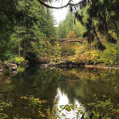 |
| Moulton Falls Bridge |
 |
| Moulton Falls |
 |
| Moulton Falls |
 |
| Moulton Falls |