
 |
| Nesmith Point Trail #428 |
Getting There
Take I-84 East into the Columbia River Gorge. Take Exit 35. Follow NE Frontage Road for 4mi to the trailhead parking lot.
It's located about 6 miles east of Multnomah Falls and about 6.5 miles to Cascade Locks + Bridge of the Gods.
I knew when I left the house that I was in for some rainy hiking conditions, wherever I chose to go. I looked at the forecast for the area, it was rain, rain, rain and some wind. Fortunately, the temperatures were in the mid-40s.
I did some research and found a hike I'd never heard of, Nesmith Point, above Elwah Falls & McCord Creek Falls. I'd done the falls hike years ago. When I've driven by this trailhead in the summer, the parking lot is usually full.
On a rainy January, I was one of 3 cars.
The Hike
Length: 8.46 mi
Elev. gain: 2,077 ft
Moving time: 3:17:26
Total time: 3:20:14
Avg pace: 23:21
Calories: 1,985
12 (Cardio/Peak)
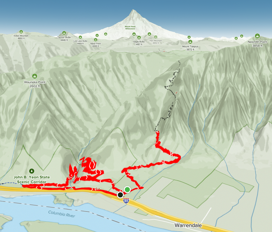
I had my sights on Nesmith Point but thought it looked like a longer hike than I had time for and energy. I just wanted to take a look and see how far I could get before I needed to start my descent.
It was smooth sailing for the first 1 1/2 miles. You zigzag through some trees but reach an area where you cross a boulder field twice and hike along steep hillsides under huge rocky overhangs. I started to get into more snow covering the trail.
I realized about 1/2 way that I'd left my microspikes in the car! dammit! I remembered packing them but never putting them in my pack. D'oh. Where I turned around, it was steep and I wouldn't have had a good time with only my boots & poles. I was sure to encounter more snow so even if I'd made it through that section, I wouldn't get much further.
Good thing because looking at the 3D map, it's a steep trail, even with the switchbacks. It does look like it levels off and the approach to the viewpoint follows the ridgeline.
I started my descent. I knew I had more daylight so figured I'd explore McCord Creeks (Elowah Falls, Upper McCord Creek Falls).
I went to the end of the upper falls trail. Then, back down to the lower falls trails. Looks like there used to be a bridge so you could keep going east.
I hiked back to the parking lot, then walked the frontage road to the Gorge Trail #400. I was pretty overgrown but still not bad to follow.
I crossed a sketchy section where the cliff had eroded. I hesitated but went anyway. Some butterflies.
I followed this trail all the way to the falls, and the other side of where the bridge was supposed to go. It was smashed up but a recognizable section.
On the way back, I got nervous again going through this section. I held onto some branches and squeezed by. Whew!
I was bumbling along back to the frontage road. I wasn't thinking and slipped on some roots and ended up on the ground. Yikes! I was getting a bit complacent on the easy terrain. I'd been so careful up to now.
Reminded me of that fall on the Mineral Creek Trail near Kachess Lake. I wasn't being careful. Gotta respect the trail and remember there's probably not going to be anyone to get me out.
 |
| AllTrails map |
 |
| Elowah Falls |
 |
| Upper McCord Creek Falls |
 |
| Lower McCord Creek Falls |
 |
| Hamilton Mountain from Oregon |
 |
| Top of my hike up Nesmith Point trail #428 |
 |
| Top of my hike up Nesmith Point trail #428 |
 |
| AllTrails map |