
Thursday, February 24, 2022

Gear: Repairing your Hiking Boots


Backstory

When I started hiking in earnest in 2020, I realized that I needed better hiking boots. 

The pair I'd gotten for my Norway trip in 2018 were actually trail runners and were awesome but too narrow. I got blisters by Day 3 which I hand to tend to for the rest of my 3-week trip. I tried thinner socks to give me more room, and thicker ones to get more cushioning but no matter what I tried, they just weren't the right fit.

When transitioned from a casual hiker to avid explorer, I knew I had to make a change in footwear.

I scoured the various "Best Gear" blog posts and reviews on REI and the like to try to get a consensus on what I should buy. I was naturally drawn to keens because of my sandals and they are headquartered in Portland. I settled on the Keen Targhee IIIs. I originally got size 10-1/2 at first but quickly found they were too snug a fit and had a weird "break" over the toes. It was summer and I hadn't accounted for use with thicker socks. I exchanged them for size 11. 

OMG! They fit perfectly with a light wool sock. I had room for my toes room to wiggle and they'd work with thicker ones too. (*I've actually switched from Smartwool to Darn Tough; separate future topic*).

In fact, I hiked Silver Start Mountain in southern WA that same day. It was tough hike but the Keens were invaluable. I had great traction and never a hint of blisters.

The rest is history.... (sort of).

Fast forward to Feb 2022. To date, I've traveled 598 miles in these boots.

According to https://gearjunkie.com/outdoor/hiking/long-hiking-boots-last

But, according to the experts, hiking boots of solid construction will carry you for at least 600–700 miles, generally maxing out at 1,000.

What about the fast and light crowd? Well, trail-running shoes go through similar abuse. And many times they step up to do a hiking boot’s job.

“Lightweight-type products like trail running would be on the lower end of the spectrum, at about 400–500 miles,” said Haddad.

Gerritse agreed. As a “rough guide” with KEEN’s hiking line, he told us, “For fast, lightweight products, expect around 400–450 miles.”
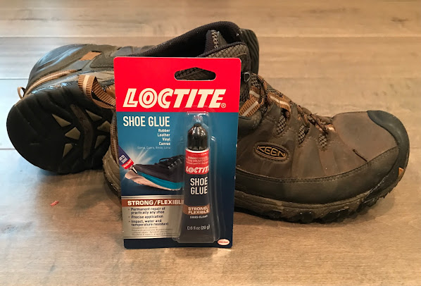
The "rub" on my Keens is that the soles are not a single mold design like other boots and my Keen sandals. At around 350 miles, I started seeing bits of rubber peel off on the sides and bottoms. I found reviews where that confirmed this is a known-issue. It was unfortunate and I was kind of annoyed that the glue was failing. It was also an indication that I'd done some serious hiking which pleased me.

I found a tube of Gorilla Glue (their SuperGlue type equivalent) and attempted to slow the wear & tear but I knew, in the back of my mind, the fixes were gonna fail eventually because it was hard & brittle but would delay having to get a replacement pair. I considered stepping up to a mountaineering boot like Salomons, La Sportivas, or Scarpas but wasn't sure it was worth the extra cost, $175 vs $230, $209, $299, respectively.

One thing that made me really reconsider the whole issue. I'd seen one of Joey Coconato's video where we, the viewers, got a glimpse of his boots which were failing spectacularly. He was hiking on snow and his boots were held together with duct tape and had huge holes. Of course, this is pretty unwise to not have proper footwear in any conditions, no less, inclement weather.

According to Les Stroud's Lemon System, this would certainly count as at least one Lemon.

However, I realized I was falling for the idea that you need the best gear to enjoy hiking. Kyle Hates Hiking has video to help beginners avoid the trap.

Ultimately, what was happening to my boots was largely cosmetic. There were a couple spots on the bottom that could potentially compromise the waterproofing but otherwise that was intact; I'd never had wet socks and wanted to keep it that way. The loose rubber parts did not affect the boot's traction or effectiveness.

Again, I took to the internet find a better option than the Gorilla Glue to extend the life of my boots.

The Fix

Of course, Shoe Goo has been around for a long time and remember using it in the 1980s to fix my skateboard shoes. I'd ground the heels off using them to brake when butt-boarding down hills.

I wanted to try something different and found Loctite on a search. I can't find the article now but one said Loctite is the preferred glue of cobblers & shoe repair professionals. 

Alright! Where do I find it? One place is in the Paint & Supplies section of a popular home improvement store.

I'm really pleased with the result. I'll state up-front that I took very little care to a "clean" repair. I literally lathered the stuff on the problem areas. For the spots on the bottom that could leak water, I used a toothpick to get the Loctite glue deep into the spots where the original glue failed. 

Admittedly, it looks pretty sloppy but it won't matter after they see some dirt and mud. The more, the better.

After 72 hrs of curing time, it's like a new lease on these boots. I've already surpassed the supposed lifespan of the Keens by 150 miles. It remains to be seen how long this kind of repair will extend my boots' lifespan. I'm optimistic for at least 200-300 miles.

Note: This post is being written prior to any trail testing. I'll update if reality and expectations are completely off.

Thursday, February 17, 2022

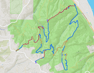
Hike: North End of Forest Park 16, Portland, OR

Footpath App Map

Getting There

Take NW Skyline Blvd north from NW Germantown Road. The Skyline Blvd Trailhead is 1.6 mi and a parking are available on right (east) side of the road.  

It was earlier than most of my other hikes here: ~12:30p. There were no cars at the trailhead.

The Hike

Distance: 9.96 miles
Elevation Gain: 2,060 feet
Calories: 1,318 (Fitbit)
Steps: 21,686 (Fitbit)
Floors
: 243 (Fitbit) 

Again, the AllTrails app failed to record my hike. Getting lame. And the Fitbit wouldn't track my heartbeat thus didn't capture any zone minutes. Argh!

It was a good hike. I made my usual stop at Benjamin George Collins bench on Wildwood. It notes his passing on Feb 14, 2002 so just a couple of days after the 20 year anniversary.

a moment of silence.
.
.
.
.
.

RIP, BGC!

The people were friendlier than usual. In fact, an older guy stopped to chat about different routes by combining the Wildwood Trail with various Firelanes and the BPA Road. I mentioned I was 1/2 through my loop and that I was heading toward Hwy 30.

The only bizarre thing was I got stuck behind three woman and 5 dogs on the Firelane 12 from the BPA Road. Usually, people hiking with dogs (if they're not jogging) tend to go a bit slower, for the dog to pp or #2. Often a group will stop and let you go by but that never happened, but these three hikers and the dogs was cruising fast and I could barely keep pace. I finally slowed down to put some distance but somehow I kept catching up with the slowest of three.

The bummer part was one of the ladies had a dog that was off-leash and she kept yelling at it every 10 secs when it wandered too far ahead of the group. The peaceful tranquility was repeatedly broken by this hollering. Ugh.

At the Firelane 12 + 15 intersection, I just stopped and let them really gain some distance. It was steep hill and I keep closing the distance. I didn't know what else to do. I didn't want to seem like I was tailing them.

I caught up on the section just before crossing Wildwood. They were all stopped, looking at the trail sign. Two of the dogs came up, wagging their tails. I smiled and held my hand down where they could sniff me out.

As I ascended the steep section of Firelane 15, I could still hear the one woman yelling at her GSD.

--

While I was back at my car, changing shoes, a guy stopped and gushed about the Jeep. I can't remember exactly, but he said something like "that's a dream rig" "so badass". I was speechless and smiling widely. I mustered a "Thanks" and waved as he drove off.

Sunday, February 13, 2022

Hike: Phlox Point via Bridge Trail & East Hardy Ridge Trail, N Bonneville, WA

AllTrails map

Getting There

The trailhead is accessible from the Equestrian Camp Parking Lot, a bit west of Beacon Rock & Hamilton Mountain.

Take WA-14 from Vancouver, WA east toward N Bonneville. Just after Doetsch Ranch you'll see the Ranger Station on the north side of the road just before the Beacon Rock parking lot. The road winds up the hill for a bit. Keep a lookout for the the Equestrian Camp turn off.


The Hike

Length: 9.35 mi
Elevation gain: 2,208 ft
Moving time: 3:32:16
Total time: 3:38:12
Avg. pace: 22:42
Calories: 1,870 (AllTrails),
2,160 (Fitbit)
Steps: 22,351
(Fitbit)
Zone Mins: 75 (65 Fat Burn, 10 Cardio/Peak)
(Fitbit)
Floors: 234 (Fitbit)

Definitely a good workout and a rare warm day in February. I still wore the usual layers, best to be prepared for cooler temperatures deeper in the valley. It's a good thing because the snow on Upper Hardy Creek Trail leading up to the Bridge Trail was completely covered but it was thawing. I was able to maneuver without microspikes the whole way, although I should have put them on for extra traction.

When I reached the East Hardy Ridge Trail, it was mostly snow free but when it transitions to the foot path you're back on the snow. There were obvious foot prints so the path was easy follow. I only punched through once to the shin. With poles and careful steps, I managed to make steady progress up to the Phlox Point Trail.

I intended to hike to Phlox Point but about 0.3 mi, the route is not clear, there are so many obstacles to get around, under, over, through. In fact, I finally put on the microspikes. It helped a bit but I didn't feel like it was worth the hassle.

The hike back down was amazing. The light was golden and it was nice and warm on the West Hardy Ridge Trail. I walked for an hour and 15 mins but it seemed longer. 


Sunday, February 6, 2022

Hike: Hamilton Mountain/Hardy Creek Loop, N. Bonneville, WA

AllTrails Map

Getting There

Take WA-14 from Vancouver, WA east toward N Bonneville. Just after Doetsch Ranch you'll see the Ranger Station on the north side of the road just before the Beacon Rock parking lot, then another road across from the bathrooms. The road winds up the hill for a bit.

I was kind of surprised to find 4 empty parking spots at just after noon in the main parking lot. There was an attendant and the upper parking lot was open (but full). It's all about timing and the Discover Pass carries some influence over people that pay by the day.

The Hike

Length: 7.34 mi
Elevation gain: 2,201 ft
Moving time: 2:59:47
Total time: 3:11:22
Avg. pace: 24:31
Calories: 1,584 (AllTrails), 3,315 (Fitbit)
Steps: 18,499 (Fitbit)
Zone Mins: 73 (Fitbit) - 57 (Fat burn), 16 (Cardio/Peak)
Floors: 240 (Fitbit)

This marks my 5th hike of 2022, 35 miles so for and over 10,000 ft of elevation gain. I've hiked every weekend so far and feel like in good shape to maintain (and improve) my fitness.

The trail from the parking lot to the top is in good shape after lots of snow and wind and blown-down trees. I think there is one tree to clear towards the top, easy to step over. 

The ridge from the top to the Saddle is pretty slushy but I still benefited from microspikes. There are several obstacles to get thru, over, around but it didn’t slow me down too much. A couple of tree branches tried to steal my hat!

Don's Cutoff (AllTrails Map)

I opted to take Don’s Cutoff instead of the Equestrian Trail.

I’d already taken off the microspikes and decided I would do without. There was quite a bit of snow but lots of debris (needles, twigs) that gave good traction. I got stopped for a minute and had to check the map. Thank goodness! 

There’s a lot of snow on the Hardy Creek trail from Don’s Cutoff and the pit toilet. Pretty normal the rest of the way.


AllTrails Map:

https://www.alltrails.com/explore/recording/afternoon-hike-a4c42bf--229

Saturday, January 29, 2022

Hike: Dog Mountain, Carson, WA


Footpath app map

Getting There

I left the house again not knowing where I was going. My last hike was Hamilton and I considered another spin up to Phlox Point but when I reached the turn off by Beacon Rock, I kept on going. 

I figured I'd checked out Dog Mountain. I really wasn't up for a 15-miler like Table Mountain and probably didn't have the time anyway; it was around noon, so when I saw a full parking lot at the Bonneville Trailhead, I knew I'd made the right choice.

Traffic was light all the way. The Dog Mountain parking lot had about 20 cars but there were will still plenty of open spots. I found one closer to the pay station.

I realized as I was getting geared up there I'd left my phone. No trail recording, no photos, no navigation. I felt naked. Nevertheless, it was overcast so I didn't really mind.

The Hike

Distance: 5.89 miles
Elevation Gain: 2,830 feet
Max Elevation: 2,935 feet
Steps: 17,089
Floors: 292
Calories: 1,366

From my Instagram Post:

I forgot my phone at home. If I didn’t take a picture, did it happen? Lol! I often use AllTrails to record my hikes but starting to use Footpath app when I want to get mileage & elevation gain after the fact. (I haven’t used the Tracking feature yet.)

I also want to keep diary of my hikes here. RA has been acting up and I’ve had to pause my meds for a few weeks. As such, today I suddenly saw some bruising in my fingers, after only a week of not being on treatment. Scary. 

Nevertheless, I will continue to hike as much as I can. Hopefully I can find an alternative treatment that’s not as hard on the body.

---

I made good time up the first set of switchbacks. Once in the trees, it was pleasant (no wind, not too chilly). My recollection of the route was hazy but still somewhat familiar. The ice/hard pack on the trail started pretty low down (maybe a 1.5 miles up). I asked some hikers on their descent about the patches of ice. I went for awhile without but I saw a long stretch of white so I put them on.

So. Much. Better. I felt invincible with the added traction. Of the hikers coming down the trail, there were more people without microspikes than those with them (60/40 split). One guy (probably not much older than me) was jogging down the trail with one hiking pole. Sure enough, he bailed right in front of me. Fortunately, he wasn't injured but I imagined having to assist this dumbass to the trail cuz of a preventable accident... SMH.

The climb to Puppy Dog View point was so much easier with microspikes. The deeper snow was gone (from last time) and it even got a bit rocky. I tried to avoid stepping on larger rocks. The traverse and final approach was pretty windy and cold. I just kept going, only glancing up occasionally to check my progress. Soon I was rounding a corner and seeing amazing views as the fog had cleared.

Somewhere before I'd seen a pair of sunglasses on the ground. I picked them up and hung them from my pocket so the owner might see them and I could return them.

I passed a pair of hikers and they both were wearing sunglasses. The sunlight and white snow everywhere was tough on the eyes, so I put on the sunglasses. I passed another guy who gave me a double-take but didn't say anything. I had feeling they were his but maybe not. For all I knew, the owner had been one of the many I'd seen on my ascent.

I spent a little time at the top.. I cruised through the trees to try to find the highest spot but without my map, I couldn't be sure. I turned around when I came to two divergent set of tracks. I returned to the trail and took a short break under a tree.

The descent was easy with the microspikes. Where the More Difficult trail splits off, I saw that guy again. He came up to me and asked if I'd seen any sunglasses (the ones I was wearing??). I knew right away and took the glasses and handed them to him. I said was I glad to find the owner but in my mind I was thinking "finders, keepers". I mentioned I was going to take the alternate route back down and we started down the trail.

He was in front and was struggling with just hiking boots. After a couple of slips and one fall, he stopped to put on his microspikes. I stopped to chat but when he said "you don't have to wait" I didn't hesitate. I said "cheers, see ya down below" and took off.

At one point, I was feeling unsure and hoped I wasn't lost. The trail was pretty obvious but there were some spots that weren't. I took comfort in knowing there was another hiker on the descent. When I passed a few hikers, I knew I was where I should be.

When I reached the trail split, I finally took off my microspikes.

I passed a few more hikers coming up the first set of switchbacks and made it back to the trailhead.

I saw the sunglasses guy while I was changing footwear. I tried to wave but he wasn't looking.

Friday, January 28, 2022

Story Time: A Ramble from Myanmar (Burma) to Northern UK


Google Earth map

While browsing the interwebs, I stumbled onto to a post pondering about the lifelong impact a brief encounter can last. The account by Gordon Bonnet about a chance meeting while traveling through a little village near Hadrian's Wall absolutely blew me away. 

A couple in their 60s (sexagenarians) "walked home" from Burma to Northern UK. The 6,660+ mile trek took the couple "a little over 3 years."

The waypoints: Myanmar (Burma) > Bangladesh > India > Nepal > Pakistan > Afghanistan > Middle East > Turkey > Greece > Italy > France > UK.

The Story

Have you ever met someone only for 2-3 days but remembered them your whole life?

Gordon Bonnet, works at Writers and Authors

Yes, and it wasn't even two or three days, it was more like twenty minutes.

When I was in my 30s I did a solo hiking trip across England, from the Irish Sea to the North Sea. When I was in a little village near Hadrian's Wall I saw an old lady, maybe 75 years old, walking toward me. She looked like she could have stepped right out of an Agatha Christie novel - pastel dress, sensible shoes, a hat with a bow, even a parasol to keep the sun off.

As she passed me, she gave me a smile and said, "Are you out for a ramble?"

I told her about the hiking trip I was on.

Her smile broadened, and she said, "Oh, lovely! I do so love a nice ramble. You know, my husband was in the foreign service, and when he retired, we walked home from Burma."

I stared at her, thinking I must have misheard her. Or, perhaps, there was a town ten miles away named "Burma." She must have noticed my astonishment, because she continued to explain. "You see, we were stationed in Rangoon, and when he retired, we had nowhere we had to be. So we decided to walk home. We crossed into Bangladesh, and then into India, trekked up into Nepal and across the northern parts of Pakistan. We were fortunate, because having been in the foreign service for decades, we knew people all through the region – they were all former British colonies, of course.

"We did take a light plane across Afghanistan, which was a bit dicey even back then. But we had a lovely time crossing up through the Middle East, then into Turkey. We crossed the Bosporus on a ferry, then went through Greece and into northern Italy, crossed the Alps into France, and when we got to the Channel we took the ferry across that, too. And presto, we were home!"

Presto indeed. I asked her how long it took them.

"Oh, a little over three years, I think.” She laughed. “We weren't really keeping track very well, I'm afraid."

And, as it turned out, she and her husband did all this when they were in their upper 60s. I'll never forget that experience - talking with the little old lady who bested my hiking experience in the sweetest, most understated fashion possible... the little old lady who "walked home from Burma."

Thoughts

Having just turned 50 last month and dealing with health issues, it can seem like adventures like this are for "younger" people who have the freedom from things anchoring them to a place, their fitness & health. I fortunate to have accumulated material things but when I'm feeling down and/or the wanderlust is high, I turn to the picture of my travels, to try to relive, in some way, my own adventures. 

That time I stayed late at work to get a release out before deadline is meaningless, even in the moment, really. That time I almost missed the Tau ferry in Stavanger, Norway and my hike to Preikestolen was in jeopardy, is indelibly etched in my mind.

This woman's account reminds me of a family story. My great- aunt and uncle were already in their 60s when I was born. When I heard the story, I'd been a skier and had hiked in Canada for almost two weeks. They lived in a rural town in southern California and had a quiet, retired life. It was hard to imagine them being adventurers. 

Sometime when they were in their 30s-50s, they'd set out in the Sierra Nevadas with some mules and horses to explore the back country for a few weeks. (I need to get some clarification on the details to make sure I'm not embellishing. The story is amazing as is.) Wow!

This seemed so badass to me but then again, think of the people that headed out West, and their hardiness and mettle. I regret not having the maturity and introspection to hear the story firsthand. It's humbling and also motivates me to be more adventurous.

Saturday, January 22, 2022

Hike: Hamilton Mountain Loop, N Bonneville, WA

Footpath App route map

Getting There:

Take WA-14 from Vancouver, WA east toward N Bonneville. Just after Doetsch Ranch you'll see the Ranger Station on the north side of the road just before the Beacon Rock parking lot, then another road across from the bathrooms. The road winds up the hill for a bit.

For the first time since I started hiking here, the upper parking lot was open. I remember going up there years ago (10+) when I had my truck. There was just one spot available.

The Hike:

Distance: 8.15 miles
Elevation Gain: 2,142 feet
Number of Steps: 22,627 (Fitbit)
Zone Mins: 110 (68 fat burn, 42 cardio/peak)
Floors: 259
Calories: 3,625

Since I was parked in the upper lot, I started my hike by heading through the campground to the Hadley Grove trail. I briefly stopped at the plaque and touched the petrified wood. 

There were quite a few people out but it didn't feel crowded. As expected, many folks only went to Rodney & Hardy Falls or the lookout below Little Hamilton. There were a pair of hikers with a dog that was a few hundred feet behind me. It was good motivation to keep truckin'. I was feeling pretty tired throughout but found the energy to keep putting one foot in front of the other. Counting the 14 turns at the top really helps.

The place were I turned around (between turns 12,13,14) was easily passable. The snow on the trail was post-holed but had hardened and was easy to walk over, plenty of footprints to follow. 

When I reached top, there was a guy resting and the pair with the dog arrived. I pondered heading to the Saddle. I noticed a hiker making their way. It seemed like they were going toward the summit (opposite direction). I sat down and put on my micro-spikes. FINALLY! This was the first time I'd worn them. 

They worked perfectly (surprise, surprise!). I stepped down the icy trail with confidence. I took my time to pick a good line through the obstacles and post holes. I loved 'em. There were a few spot where I was walking on mud and rocks but I could see there were more patches of ice/snow. I didn't want to damage the spikes.

When I descended the zag, I dropped below the snow line. I easily slipped off the spikes and secured them to my pack waist strap to save time.

The Saddle had a bit of snow but was mostly barren. A couple of hikers and a dog were enjoying the sunny views on the other side. 

The trip back to down was pretty standard but there were lots of downed trees. The Parks crew is going to have some work to do to make the Equestrian Trail passable with a vehicle.

When I reached stairs by Rodney Falls there was a hiker with a cat in a special backpack. I'd seen them earlier. The way they were standing it looked like they were waiting for someone to come up. For a split second I thought I was "jumping the line". I asked this person but they were wearing headphones. After fumbling with their phone and had finally removed one headphone to ask "What??". I sheepishly admitted it was a dumb question and tried to explain. Unfortunately, I only confused the issue with my "clarification" and just said "sorry" and took off down the stairs. Welp. This time, there was someone coming up but they graciously stepped to the side so we could pass with some social distance.

I took the Hadley Grove Trail again and stopped at Little Beacon. The photos below are from that area. The lighting was amazing. I started back and cleared the lookout for a group of 4 that had climbed up there.

West view from Little Beacon

South view from Little Beacon at Beacon Rock

Northwest view through trees from Little Beacon

Hardy Creek crossing at the Equestrian Trail

Another west view from Little Beacon