Sunday, August 18, 2024

Hike: Tamawanas Falls + Cloud Cap Inn/Tilly Jane, Parkdale, OR

Getting There

You can reach this trailhead from Hood River but I was still unsure where I would land when I left the house. I drove I-84 from Portland to Exit 16 and headed toward Mt Hood via Hwy 26.

My tentative plan was to hike up to McNeil Point from the Top Spur Trailhead but when I reached the turnoff for Lolo Pass, I kept driving.

My next thought was hiking up to Tom, Dick, and Harry Mountain via the Mirror Lake Trail #664. As usual the trailhead parking lot was packed to the gills. I might have found a spot in the Ski Bowl parking lot but wasn't sure. A full lot means a lot of people on the trail. 

The burrito I got at New Seasons was not sitting well. I stopped in Government Camp to use the loo and get some fuel. I searched for a hike nearby and found Tamawanas Falls.

When I passed by White River, where I've snowshoed several times, there was plenty of room in the parking lot but I was kind of in a funk. I kept going. I sorta thought I drive all the way down to Hood River and try to hike Lyle-Cherry Orchard.

When I reached the Tamawanas Falls Trailhead, it was overflowing with cars. Argh! I zoomed by. I sorta thought I drive all the way down to Hood River and try to hike Lyle-Cherry Orchard. Not far down the road, I saw the Polallie Trailhead. I had no idea what trails this would give me access to but I pulled over and parked.

I geared up and poked my head around the corner down the road. I opened my Google Maps app and realized the trails were across the street. I ran across the road and started up.

The Hike

Length: 4.89 mi
Elev. gain: 1,078 ft
Moving time: 2:00:34
Avg pace: 25:11
Calories: 1,220
Total time: 2:10:33


There was a junction not far up the trail, after the first short switchback. I looked at the map again and saw that one trail followed the road and I imagined hearing the traffic. Nope. So I opted to go the other way, Elk Meadow. I still had no idea where this was leading but I didn't really care. 

To be honest, I was a bit relieved when a couple passed me in the other direction and asked what I knew about the "road not taken". I said I didn't know and picked this one since it was away from the road. I hoped there was a viewpoint somewhere and kept heading deeper into the forest.

When I reached the trail junction for Tamawanas Falls Trail, I had a new plan! The waterfall and I didn't have to hike with the throngs of people I saw parked at the trailhead.

I passed another pair of hikers heading the other direction.

Eventually, I reached the junction for the Tamawanas Falls Trail, the out-n-back part. There were lots of people here but I was glad I had a plan. I would take a spin to the falls, snap some photos and at least have got some trail time.

I only lingered for a little while then started my return hike to the car. Instead of returning the way I came, I followed the Tamawanas Falls Trail to the East Fork Trail.

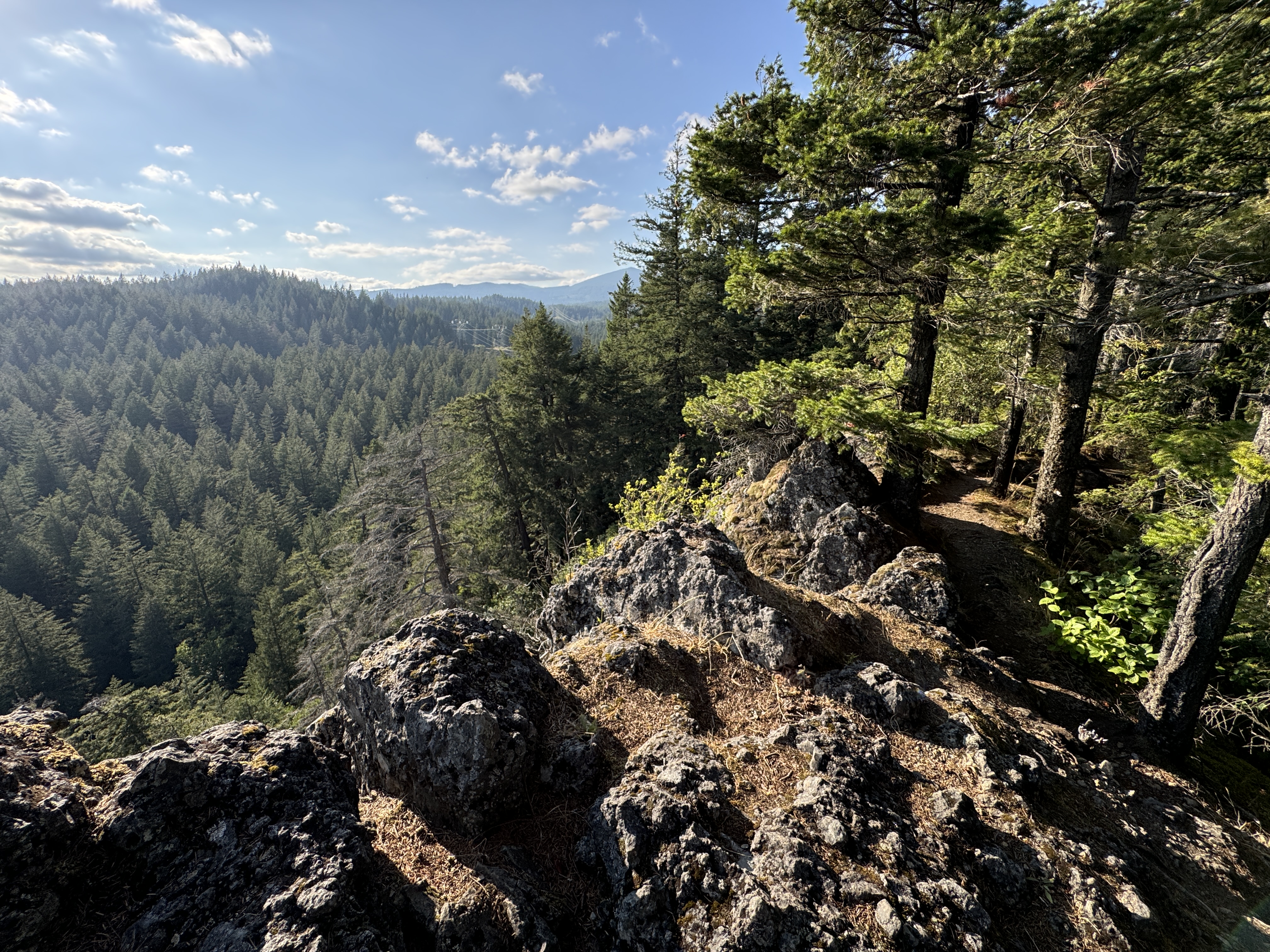
Such a beautiful trail along the North Fork Cold Spring Creek.

Indeed, the North Fork Trail parallels Hwy 35 and I could hear the car noise. I reached the Polallie Trailhead and my car.

Now what? It wasn't a very difficult or long hike.


---

I thought about driving back to Portland the way I'd come, Hwy 26 through Gov't Camp & Sandy. Instead, I continued northbound on Hwy 35. Less than a mile from where I'd parked, I saw the turn for Cooper Spur. I considered going to Laurence Lake and trying to get some views of the Parkdale Lava Flow.

When I got to the Cooper Spur Mountain Resort, I noticed Cloud Cap Road on the left. Hmm.

I followed it up to the Tilly Jane Sno-Park parking lot and made a mental note. This must be the start of the difficult trail up to the Cloud Cap Inn and the Cooper Spur next to Eliot Glacier.

I knew I was on the road to the Inn. I'd been wanting to visit this place for several years!

The road wasn't too bad, I passed a bunch of lower clearance cars on their way down. It's narrow in spot and not devoid of potholes and dips but it was much better than the road to Cold Springs Campground to the South Climbing route on Mt Adams.

A couple of vehicles appeared in my rear view mirror. I found a spot to pull over and let them pass.

When I got to the junction for Tilly Jane, it said one mile and I calculated I was adding three miles to the drive but was surprised that the campground was just around the corner, more or less. (Maybe it said 0.1 miles). I wanted to see the A frame but somehow missed it. I photographed the Ranger Station and walked through the campground. The A-frame was just 100 meters from where I'd parked. Oh well.


I hopped back in my Jeep and headed to Cloud Cap. Wowwee! The views were endless.

I hiked around to the side of the Inn that faced Mt Hood. It was hidden in clouds on the SW side, including the summit. It made for some dramatic photos. I could see Eliot Glacier and it seemed like you could almost touch it.

I sorta wished I'd come here first so I could hike to the end of Cooper Spur! Next time! Maybe before the end of this summer.


Wednesday, August 14, 2024

Hike: Hamilton Mountain + Hardy Creek, N Bonneville, WA


Getting There

Just after Doetsch Ranch you'll see the Ranger Station on the north side of the road just before the Beacon Rock parking lot, then another road across from the bathrooms. The road winds up the hill for a bit.

It was early afternoon and the weather was questionable: overcast skies but humid. I accepted that the views might be obscured but then again, I'm often treated to a surprise once I get up to Little Hamilton and higher.

The Hike

Length: 9.12 mi
Elev. gain: 2,346 ft
Moving time: 3:56:28
Avg pace: 25:56
Calories: 2,392
Total time: 5:08:21


With the MSHI volunteering and WTA trail work, I haven't been getting many long hikes in this summer. The whole thing with vertigo also derailed me a bit. I returned to my old favorite mountain and trail to do a little catch up for my MSH summit attempt next month.

While I feel strong and fit, rarely do I start this hike with a "crush it" attitude. It's more of a "I hope I make it to the top." I know I had plenty of day light even if my pace was slower than usual so I plodded along, making sure to smell the flowers and make my requisite stop at Little Hamilton for its amazing 360° views.

The clouds still blanketed the sky but it was also a bit humid. I drank my water and popped a couple electrolyte tablets in my mouth.

Panoramic view from Little Hamilton

Cloudy skies over Hamilton Mountain

North Bonneville, WA

I knew I wanted to add the Saddle, Don's Cutoff, and Little Beacon but for now I was just happy to reach the top. And the clouds had mostly cleared. It felt less humid.

Table Mountain from the Hamilton summit

I was carrying my foldable hand saw and cut some low branches on the ridge between the summit and the Saddle. I thought I was alone until I heard voice behind me rather close. I wanted to do my trail work in anonymity so I hurried with a cut, tossed the branch aside and scurried. I'm sure the people behind me heard my rushed steps or perhaps, my backpacks bouncing on my hips & shoulders.

I reached the Saddle and slowed down a bit. I made my way to the other side where took off my pack and had lunch. I wasn't hungry but my sandwich was good in the outdoors and sunshine.

The two hikers I'd heard behind me arrived to the Saddle. They had a dog. I looked up from my lunch and said hello to them and acknowledged the dog. They didn't reply but looked at me. Weird. I don't get it when people don't reciprocate a simple hello or wave or something.

The Hamilton Saddle

Bonneville Dam from The Saddle

The other hikers had stopped in the shade as I was finishing up. I walked past and gave an obligatory wave but they didn't even look up. I continued down the Equestrian trail. When I reached the junction, I took Don's Cutoff. I hoped I didn't see these two again because they would probably think I was following.

Fortunately, I reached the Hardy Creek junction at the creek crossing without seeing anyone.

I love the lower Hardy Creek trail.

I saw a few people at Rodney Falls wearing Converse sneakers. I was going to stop at the falls overlook but noticed a person sitting there. I didn't need to go up there.

At the powerlines, I took the trail through Hadley Grove. I was going to take the shortcut from the access road but found it overgrown and I wasn't sure if there was anything poisonous or with thorns. I stayed on the gravel road all the way to the campground. I double-backed into Hadley Grove and made it to the saddle at Little Beacon. 

A woman was there on her phone. She finished her called with "I love you too, Mom". We chatted briefly about how picturesque the place was and she mentioned seeing a turkey vulture on the rock. I pointed at the steep hill I was going to climb from additional views. I noticed that the log that was blocking the path for awhile had been cut. We wished each other nice rest of the afternoon.

I swiftly ascended the embankment to the ridge. I had the place to myself, as usual.

I stayed up there for awhile and was thankful for being able to come to this place periodically. I thought about waiting until sunset but it was going to be at least an hour or two. Oh well, still some amazing shots & lighting.

Looking west from Little Beacon Rock

"Hi!"

Beacon Rock (proper) from Little Beacon

Looking north from Little Beacon Rock


Saturday, August 10, 2024

Hike: Ape Canyon, Mt St Helens, Cougar, WA


Getting There

It's 28 miles from Woodland to the Cougar. There are a couple of gas stations here. Continue east on SR-503 which becomes Rd 90 for 9.5 miles to Ape Cave. Looks for the sign to Ape Caves, June Lake, Climber's Bivouac, Ape Canyon & Lava Canyon which is Rd 83. It's 0.3 miles to Trail of Two Forests and 0.7 miles to Ape Cave.

Ape Canyon and Lave Canyon are 10 miles north at the 83/90 junction. The trailhead is at the end of Rd 8300 on the southeast side of Mt St Helens.

The Hike

Length: 10.77 mi
Elev. gain: 2,123 ft
Moving time: 4:20:35
Avg pace: 24:12
Calories: 2,636
Total time: 5:06:26


Talked to a lot of mountain bikers, all were friendly, esp when passing by (letting me know if others were behind them), many thanks for being out there as a MSHI volunteer. 

One person was asking where Plains of Abraham was located. Met more mtn bikers at the Loowit/Ape Cyn junction that knew my name (from the other mtn biker), they were happy for the MSHI presence in the monument. 

On my way back down, I met two backpackers in their 20s that recognized the MSHI logo and asked for stickers. 

Lastly, I met two trail runners near the switchbacks; one had done the Bigfoot 40M trail race the day before and was heading back up to the Pumice Butte to take photos with their race apparel.


Sunday, August 4, 2024

Hike: Glacier Overlook @ Mt St Helens, WA


Getting There

This was my second GOH, but this time as guest, patron. Since field camp wasn't offered or an option, I chose to camp somewhere just outside the monument. I checked nearby campgrounds like Tower Rock (near Cispus Learning Center) and Iron Creek but neither had availability. I didn't want to stay as far away as Packwood, nor foot the bill for a room.

Since I'd missed the WTA/MSHI Jamboree, I decided on Wakepish Picnic Area. I drove to the gate on NF-25 to take a look and scout for a spot off the road. None appealed to me and I didn't want to use a cat hole. When I pulled into Wakepish, there were a few cars but I didn't see or hear any people. I wasn't going to make much a footprint and decided against setting up a tent I'd have to breakdown in the morning. What if a ranger had asked folks to move along in the middle of the night since this wasn't officially a campground?

I made my cocoon in the back of the Jeep. A guy with a dog eventually pulled up next to me, about 20 feet away. I ignored him and kept rearranging my gear for the night. I cautiously approached and asked if I minded him being there next to me. What was I supposed to say? I said "of course. no worries". He made some comment about his dog being friendly and would likely come to visit me at some point. Fine, I thought.

I could have been more social and I almost took him a copy of the Volcano Review but thought it would invite more conversation than I wanted to engage in. I took off my MSHI hat to keep a lower profile.

I sat outside to read until there wasn't enough natural light. I climbed into my truck and got comfy.

The next morning, I put my sleeping bag, pad, pillows away and un-built the cocoon. I took off for Windy Ridge to rendezvous with the group.

We had our pre-hike orientation talk at the little amphitheater, then carpooled down to the trailhead. There were only 4 other paying guests. Two friends rode in my car. The guides, MSHI volunteer, and other two guests took three other cars to the road construction site on the Truman Trail.

The Hike

Distance: 6.77 miles
Elevation Gain: 1,760 feet
Max. Elevation: 5,277 feet

Note: This isn't the actual hike route. We are accessing an area that is off-limits to the general public through special permission from the USFS & the Cowlitz Tribe, I didn't want to make the actual route public. This is just the AllTrails map for Loowit Falls, which IS open to the public.

Additionally, we had access to the trail from the staging site for the Spirit Lake tunnel project road.


The group was really chill. We stopped a few times along the way for some interpretation about the 1980 eruption, the geology and landscape before and after the eruption, the cultural significance of the mountain to the Cowlitz tribe and other indigenous people that used to visit this area.

We didn't see any mountain goats like we did on the Training hike in July. We did see bits of their fur which was know is collected periodically by local Cowlitz people.

 It was hot but not oppressively. My sunshirt was perfect to keep me shaded, protected from UV rays, and still allow the breeze to filter through the fabric. The views were incredible!

So fortunate to be able to visit this special place that few have seen and been to. The hike was confidence building on several levels. To be able to support guide team as a 2nd year MSHI volunteer and reaffirm my physical fitness following the bout with vertigo just a few weeks before.

As with the train hike, we did our round table "roses & thorns" (or peaks n valleys). Basically, the high and low points of the day. Unanimously, folks only gave their high points (roses/peaks) and offered low points (thorns/valleys) as straw men. Probably, for decorum, in public-group setting, but also genuinely that we had great crew, small, and there were no hitches.

We drove back to Windy Ridge and went our separate ways. A good day.

2004-2008 dome in the foreground


Mt Rainier & Spirit Lake

Break time, mid-hike

Approaching the glacier overlook

Mountain Goats in the distance

Lunchtime

Mt Adams

Windy Pass