Saturday, March 11, 2023

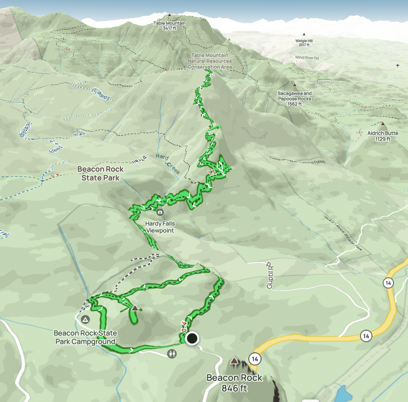
Hike: Hamilton Mountain, Little Hamilton, Little Beacon Rock, N Bonneville, WA


Getting There

Take WA-14 from Vancouver, WA east toward N Bonneville.

Just after Doetsch Ranch you'll see the Ranger Station on the north side of the road just before the Beacon Rock parking lot, then another road across from the bathrooms. The road winds up the hill for a bit.

The Hike

Length: 6.82 mi
Elev. gain: 2,231 ft
Moving time: 3:18:22
Avg pace: 29:04
Calories: 1,996
Total time: 4:07:35


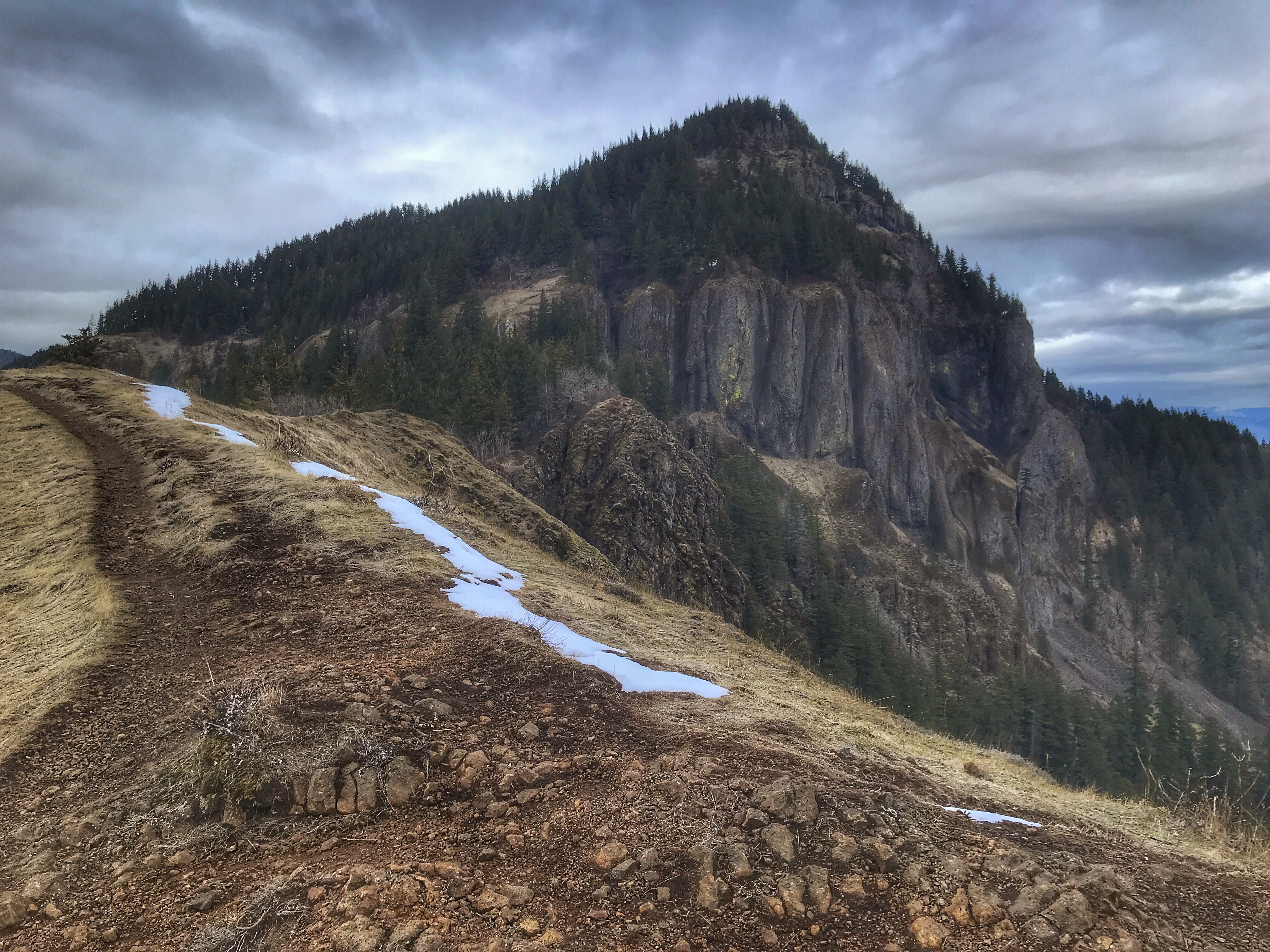
Another snowy hike up Hamilton Mountain. I post a lot of photos of this area. Definitely my go-to spot because it's relatively close, still presents a challenge, and the constantly changing conditions are beautiful to photograph.

Even though the parking lot was pretty full and the overflow was available near the campground, I didn't see that many people on the trail. Usually folks just go to Rodney Falls and back. 

I didn't encounter snow until I started traversing the backside of Little Hamilton. It was really slushy and soft. There were puddles of icy water so I tried my best to avoid testing my boots on their waterproofing.

For the entire ascent I went without extra traction. It was slippery at times but no major issues.

A trail runner passed me. I'm always impressed that someone can run up the mountain and back with light clothing and just minimal supplies (water, snacks). The person had shoes with extra wide treads for extra stability and surface area for these kind of conditions.

Reaching the top is mostly ceremonial but the views are often really good when it's clear. The trees prevent are good 360° view but you can see Table Mountain, Dog Mountain, the Columbia River, and Bonneville Dam. The snow level at the top was higher than it was last time so you are a bit higher up. I was able to see the river to the west through the branches.

I've been wanting to do the Saddle-Hardy Creek Loops but it just hasn't been in the cards lately due to the snow. I saw footprints heading down the ridge. I know it's doable but judging by the conditions last Tuesday, the Equestrian Trail is about 6-8" deep. I have no idea what shape the Hardy Creek trail is in at the moment. (Need to budget another hour or so.)

At the top, I put on my mini-gaiters and microspikes for the descent. I discovered I'd lost one of my hats. There wasn't anyone around so I knew I'd see it on the way down. Right after I started the return, I heard some grunts from a guy. Just when I saw him, I saw my hat. Woohoo. He asked how much further. I said another 50 yards and noticed the running shoes. SMH.

Further down, I encountered this guy's two buddies, also not dressed for the conditions. One guy was having a helluva time in this tennis shoes and cotton hoodie. They were loud but I tempered my annoyance.

The guy from earlier appeared from the top. He said he was underwhelmed by the top. I get it but also recognize that a lot of people don't appreciate the simple things. Every time I hike here, there some doubt that I'll make it due to conditions or fitness or injuries or something. I'm 50 years old with a disability. (Oh, the youths :)

I passed another group where the lead person was in shorts, t-shirt and was carrying cotton sweatshirt. Why!?

I made my way up the side trail for my requisite visit to Little Hamilton. Not many folks had been up there since the last snow fall and they hadn't followed the actual trail very well. 

The views were gorgeous as usual.

As I made my way out of the snow, I stopped to remove the microspikes. Good to be back on dirt/mud.

My boot and pant legs had been cleaned with the snow but now I was getting dirty again.. Oh well.

Near the Hadley Grove junction, a guy and girl were hiking up toward Rodney Falls. Guy had his shirt off.. It was 40 degrees. I don't get the bravado thing.

I headed towards Little Beacon. When I reached the saddle, there was a couple taking photos. I zoomed up the steep hill and had the place to myself. The lighting was amazing. I took off my pack for a min. It wasn't long before I heard that couple. Since I'd been up there numerous times, I figured I'd let them enjoy it. Their English was broken. I hope they didn't think I was leaving because they'd showed up. I was giving them space but doubted I could convey that quickly. I smiled and pointed over my shoulder that there were more great views behind me.

Another great hike. My left ankle and heel felt pretty good. Overall, a success.

Upper part of trail

Rainbow over Table Mountain

Beacon Rock from Little Beacon

Hamilton Mountain from Little Beacon

Columbia River

View through the trees


Columbia River from Little Hamilton

N Bonneville

Columbia River

Heavy snow but it's soft

Snow on trail near the top

The Hamilton summit

Upper trail


Tuesday, March 7, 2023

Hike: Hardy Ridge + Equestrian Trails, N Bonneville, WA

Selfie on Hardy Ridge Trail

Getting There

The trailhead is accessible from the Equestrian Camp Parking Lot, a bit west of Beacon Rock & Hamilton Mountain.

Take WA-14 from Vancouver, WA east toward N Bonneville. Just after Doetsch Ranch you'll see the Ranger Station on the north side of the road just before the Beacon Rock parking lot. The road winds up the hill for a bit. Keep a lookout for the the Equestrian Camp turn off.


The Hike

Length: 6.84 mi
Elev. gain: 1,394 ft
Moving time: 2:51:33
Avg pace: 25:04
Calories: 1,726
Total time: 3:08:12

AllTrails map


Last min hike at Beacon Rock State Park. I was intending to hike to Phlox Point via Equestrian Trailhead but found the Hardy Ridge Trail tough without snow shoes. The snow was slushy and soft so I ended up post-holing a lot. I turned around before I reached the switchbacks. 


Hardy Ridge Trail

Looking west from Hardy Ridge Trail

Hardy Ridge Trail

I thought I might be able to make it to the Hamilton Saddle but it was getting "late". The snow on the Equestrian Trail was heavy and not much different than the other trail. I only made it to the Hardy Creek Trail (picnic bench).

While I didn't reach either Phlox Pt or the Saddle it was still good to be out in the snow and trees.

Hardy Creek

Hardy Creek Trail/Equestrian Trail junction

Friday, March 3, 2023

Hike: Wahkeena-Multnomah Falls Loop II, Corbett, OR


From Multnomah Creek Bridge on Larch Mtn Trail #441

Getting There

Another outing where I was "all dressed up but no where to go." Well, there were plenty of options but I didn't want to do Forest Park or Hamilton but wanted something familiar. I considered Cape Horn but naw... back to the Multnomah Falls. The Tripcheck cam showed a mostly empty parking lot.

The closer I got to Troutdale, the worse the weather looked in the Gorge. The fog was dense and it was raining.

Again, I liked being able to park between the eastbound and westbound lanes, instead of having to get on the Historic Hwy. Plus, real or imagined, I'm guessing this parking lot is "safer" due to high turnover and cameras.

I pulled into a parking spot and watched the raindrops on the windshield. I thought about the recent snow and now rain making the hike slushy and damp. I made myself a "deal". I would just do a short hike up the Wahkeena Creek to the Vista Point view and back (or as far as I could go.)

I suited up and walked to the tunnel under I-84 to the road.

The Hike

Length: 6.01 mi
Elev. gain: 1,693 ft
Moving time: 2:27:42
Total time: 2:48:45
Avg pace: 24:35
Calories: 1,486

AllTrails map

The Return Trail #442 between Multnomah Falls Lodge and Wahkeena Falls was clear of snow. I was able to go without spikes for quite awhile.

On the lower part of the Wahkeena Trail #420 (the switchbacks) was also snow free for the most part. In fact, I was well into the middle section before I stopped to put on the microspikes. The trail was well-traveled and packed down but the rise in temperatures and rain had turned the ice into unstable slush. I was slipping a bit but was glad to have the added traction.

Near the top of the canyon, there was a spot on the trail that gave me pause. The snow bank had given way showing a sheer drop, one of those false steps that changes your day. Yikes. I hugged the hillside.

The burn area (see the bowl below Devil's Point) was easier travel but the slushy did add a bit of resistance. The contrast of white snow and few burned tree stumps created a canvas of shapes that looked like people or large animals. I stopped a few times and stared to look for movement but eventually I realized what I was looking at.

When I reached the View Point/Devil's Rest junction, I considered my options and fitness. My ankle was aching a bit but I felt good. Devil's Point was not in the cards today and I wasn't ready to head back down so I said 'fuck it' and decided on a loop.

I was mildly apprehensive about the section of the trail past Multnomah Creek. Last time was a bit gnarly.

A hiker that looked under-dressed came the other direction. The sight calmed my own nerves but also thought that the guy in a sweatshirt and cowboy boots. I saw his heel prints in the snow way up here. The guy up was passing was just in a wool fleece and light boots. Here I was with multiple layers and a winter coat on my pack. This gives me an idea for another post about preparedness in different seasons. I asked about the trail conditions below. Seemed like the hazards I'd encountered before were gone. Whew.

At the junction to Multnomah Falls, I saw the steel bridge about 0.1 mile up the Larch Mountain Trail #441. Looked like a good spot for some photos (see below). I'd like to hike up to Sherrard Point sometime.

After a short detour and photo op at the bridge, I started down the final section along the creek. There was a lot less snow so it felt safer on the cliffs past Ecola Falls, Wiesendanger Falls, and Dutchman Falls. The icy slope that was there last time was totally gone. Huge relief.

Back on the paved trail there were lots of people slipping and sliding in the street shoes. A few people kind of smirked when they saw me with pack, boots & poles. Probably thought I'd suited up for the same hike they were doing with high tops and cotton sweatshirts. LOL.

Around switchback 5 of 11, I passed a couple of woman who cheerfully let me zoom by. A few turn later I heard her shout "did you run?".. I looked up and smiled and laughed and waved.

Another good hike. I'm glad I wasn't deterred by the rain. Worth it!


Instagram post text:

Nice loop hike starting at Wahkeena Falls, ending at Multnomah Falls. Mostly snow covered route, pretty slushy tbh. My microspikes were slipping quite a bit even though the trail was well packed down. It was much less scary on the section by Multnomah Creek. When I was here in January, the creek was raging and there was an icy slope (*slide*) below Wiesendanger Falls that you had to traverse. No margin of error. Today, the water level was low and that icy slope is gone.
When I got to the parking lot, it was raining and I pondered if I wanted to hike. So glad I went for it!

Friday, February 17, 2023

Hike: Hamilton Mountain, Beacon Rock SP, N Bonneville, WA


Getting There

Take WA-14 from Vancouver, WA east toward N Bonneville.

Just after Doetsch Ranch you'll see the Ranger Station on the north side of the road just before the Beacon Rock parking lot, then another road across from the bathrooms. The road winds up the hill for a bit.

The Hike

AllTrails map

Length: 6.84 mi
Elev. gain: 2,231 ft
Moving time: 3:16:04
Avg pace: 28:40
Calories: 1,972
Total time: 3:41:16

FitBit Stats:
Steps: 20,463
Calories: 3,388
Distance: 9.4 miles (incorrectly estimated by steps x tread length)
Zone Activity: 78 minutes (64 fat burn, 14 cardio & peak)

I was glad to take another spin up my favorite mountain. I'm still dealing with pain in my left foot, specifically anterior ankle impingement and plantar fasciitis. Not sure if one is causing the other.

It seems the best remedy is to stay off that foot and not aggravate the injury. However, being an avid hiker, this is difficult. I really want to get out there and take some photos and it's so beneficial for my mental well-being.

I made moderate progress on my ascent. I noticed part of the trail that were damaged due to people going around the snow. I read an article that implores hikers to just power through the mud and whatnot and avoid going off trail.

On the last section of the hike (with the 14 switchbacks), I noticed my ankle was hurting quite a bit. I made it to the top but didn't want to linger for too long because I was worried about my descent.

While this pain is not even as bad as I've felt with IT band tightness, it still worried more more. I'm 99% sure there are not fractures or damage.

Actually, as I descended the pain seemed to fade enough that I didn't notice it anymore. I made sure to stretch my calves and rotate my ankle in both directions periodically. Whew.. I wasn't as worried anymore.

I popped up to Little Hamilton for the obligatory views. It was grand as usual.

A lightly dressed hiker (or trail runner) appeared. He oohed and aahed and continued down the face of Little Hamilton. (I've done a few times in warmer weather. It's just narrow but one should exercise lots of caution.)

I proceeded back to the main trail and the switchbacks. I expected to see that hiker still on the hill or making it through the switchbacks. I didn't see him. I thought it was peculiar.

There was one guy resting about 1/2 way down. I'd intended to ask if he'd seen that hiker go by but he disappeared behind a tree at a lookout spot. I kept an eye out but never saw anyone.

I made a point to look up at the cliff (Little Hamilton), hoping I didn't see a stranded hiker or worse. Nothing.

I assumed this person was a trail runner and had already made it down much faster than I expected.

When I reached the power lines, I still had plenty of daylight so figured the views from Little Beacon were going to be excellent.

I encountered another hiker/photographer there. I said hello and climbed up to the lookout. A few mins later the photographer showed up, apparently her first time up there. I mentioned the slab of petrified wood holding the Hadley plaque.

She snapped a bunch of photos and left. I lingered for awhile, mostly to give her time to get down so it didn't seem like I was following or crowding her.

I saw her one more time in the campground. I waved and walked briskly by & back to the parking lot. 

I err on the side of caution when encountering solo hikers, esp woman. I don't know their comfort level, if they've had creepers in the past, generally just wanting a wide berth to maximize the feeling of being outdoors & enjoying the solitude.

(Big) Hamilton Mountain from Little Hamilton Mtn

Hardy Creek near Rodney Falls

Viewing platform at Hardy Falls

View from Hardy Falls.
Yeon Mountain on Oregon side of the Columbia River Gorge
The faint outline of Hardy Creek at the bottom.


Saturday, February 11, 2023

Hike: North End of Forest Park 23, Portland, OR

View from BPA Road

Getting There

Take NW Skyline Blvd north from NW Germantown Road. The Skyline Blvd Trailhead is 1.6 mi and a parking are available on right (east) side of the road.

Today, I was actually headed to Sauvie Island and Wapato Greenway for a short, flat hike. It was too late to get all the way out to Warrior Rock. As I approached Newberry Road, I make the quick decision to head up to Skyline.

 At the Wildwood Trail parking lot, there were 7-8 cars. I probably could have found a spot but continued to my usual trailhead. I was going to do an abbreviated version of my usual hike.

AllTrails map

The Hike

Length: 4.72 mi
Elev. gain:
1,017 ft
Moving time:
1:25:24
Total time:
1:27:08
Avg pace:
18:07
Calories:
859

FitBit
Steps: 11,458
Floors: 131
Cals: 2,568

Sidelined (sorta) due to anterior impingement and plantar fasciitis in my left foot + ankle. Argh! It happened after my last hike here. I've had range-of-motion issues since a football injury in high school in my left ankle but it's never posed this kind of problem. It could be exacerbated by the arthritis. Seems doubtful but the hike before at Nesmith Point Trail in the Gorge was where I got absolutely soaked. I wondered if this affected my boots; I tried some different sole inserts. Or, maybe I need to do more stretching before strenuous hikes. I may tried 200-400 mg of ibuprofen before the next hike to see if that alleviates the pain. All speculation.

The heel pain and ankle tightness comes and goes and are probably related to each other. I'm still waiting to get a referral to a podiatrist. I wanted to take a short hike to test myself and the weather was just too nice not to head out.

---

I stayed on the fire lanes in Forest Park. When I got to the Wildwood intersection, I continued on Firelane 15 to Firelane 12. Before the drop a couple were looking at their phone, probably deciding their route. I waved and zoomed by. 

When I reached BPA Road, I considered make a loop with Wildwood but kept going to the end of the road where you can see the mountains.

The Cascades were out today. The sun was reflecting off the snow on Loowit (MSH) and Klickitat (Mt Adams), and I could just make out Tahoma (Mt Rainier). Worth a little discomfort.

I could hear a puppy barking really loudly. I saw the dog before I saw the owner carrying a big stick. I made the dumb joke "is that the branch manager?". (eye roll, sigh).

On the return, I still was going to do the Wildwood section but dropped down Firelane 12 again, making this hike a true "out-n-back".