Thursday, July 8, 2021

Hike: Coldwater Peak via Boundary Trail, Harry's Ridge, MSH, Toutle, WA


AllTrails maps
 

Getting There

Take I-5 from Portland to Castle Rock. It's 55mi from Kenton to the exit 49.

There are a few gas stations to fill up here. 

It's 62 miles to the Johnston Ridge parking lot/trailhead and it takes about 1 hr (if you're going the speed limit ;). 

This lot had quite a few cars compared to the last few visits. I parked hear the trailhead sign, put my window shade up, geared up and set out.


The Hike

Length: 13.05 miles
Elevation Gain: 3,117 feet
Type: Out and Back

Even since I hiked to Harry's Ridge I've been attracted to this peak. I saw a high spot from the parking lot and mistaked it for Coldwater Peak. It's actually behind the one I thought it was.

Last time I only got a little ways up before I got to big snow patches. I knew I wanted to come back to 'conquer' this climb.

My interest was renewed when I saw it again with my mom on our trip out there.

The weather was great and not too warm.

The first part of the trip is relatively easy, to the bottom of Harry's Ridge. From there, I continued on the Boundary Trail up and up.

The snow was long gone, esp. since the heat dome event. 

When I got to the top of the first section, there were a couple of women hiking towards the peak and a guy coming back down the trail. We chatted for a min about where to get paper trail maps, etc. The girls let me go ahead since I was traveling a bit faster. I didn't confirm but it looked like they had camping gear and were heading to Mt Margaret or The Dome.

The trail gets really interesting as you get closer. Esp. the steep section before going through the rock.

At the shoulder after the rocks, there is a trail junction for the Coldwater Lake trail. I noticed there was signage about an upcoming Trail Run.

I continued on the trail but was feeling a little uneasy. This was going to be the longest hike to date. Did I have the energy, stamina to go up and back down?

I reached the trail junction for the trail up to the peak or continue on the Boundary Trail. I figured I'd go as far as I could, maybe get some views of St Helens Lake below. Definitely epic terrain.

After the first couple of switchbacks, I looked toward the pass and saw the two girls hiking. I thought, Oh Good, some company. I bit further up I looked for them again and saw two more people and a dog. This gave me the motivation to make it to the peak. 

Murphy's Law: While I was ascending, the clouds or some fog was rolling in. It didn't look like a storm but I knew my view of MSH was going to be impacted. Actually the cool air was refreshing.

I laughed out loud that I'd made it all this way only have nature block my view~! I knew my views from lower down were just as amazing as from on top. (Guess I'll have to go back!).

I waited for about 15mins while exploring. I fully expected to see the two girls (or the other hikers) but they never showed. (Guessing they kept going to The Dome). The cloud/fog never receded so I started my descent.

About 1/2 way down, it looked like the fog was clearing! Dammit! :D I thought about turning around and going back up but decided it was fate and I still had a decent hike back. I also agreed to take a spin up Harry's Ridge if I was feeling strong.

I took another video on the way back.


As I got closer to Harry's Ridge, my criteria changed from "if I was feeling strong" to "if there are people up there" (i.e. I'm not alone). (Weird that I seek solitude but also that seeing other is comforting.)

There was a large family hiking down as I was going up.

I had the top to myself and was able to just stand there and stare in all directions. This is what it's all about. I do a lot of hiking where I'm moving the whole time. It was nice to stop and enjoy the scenery.

I really need to do some hike-in camping so I can really "stop to smell the wildflowers".

Making my way to Coldwater Peak

Looking east to Mt Adams

Fog/Clouds rolling in

Panorama of St Helens Lake

White Pasqueflower (Anemone occidentails)

Lots of cloud cover from Coldwater Peak

Another view of St Helens Lake

Approaching the summit, heavy clouds

More view of the top of Coldwater Peak

Volcano monitoring equipment

Looking W/SW at Johnston Ridge & Coldwater Lake

Panorama looking south towards MSH and Johnston Ridge

obligatory selfie from the top

Looking below the peak; Spirit Lake in upper left

Closer view

Boundary Trail sign (Trail Run July 10/11)

Clouds have cleared, MSH, junction to Coldwater Lake trail

Looking back at Coldwater Peak <3

Hole in the Rock!


Now MSH is in full view (again!)

Panorama of Coldwater Peak, St Helens Lake, return trail

Epic view of Spirit Lake, Harry's Ridge and MSH


Tuesday, July 6, 2021

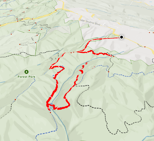
Hike: Forest Park (Firelane 12, 15, Wildwood, BPA), Portland, OR


AllTrails map

Getting There

Take Skyline Blvd north from NW Germantown Road. The trailhead is 1.1 miles from there. The parking lot can be difficult to see, it looks like someone's driveway. There are 5 or 6 spots in the trees but don't block the gate :)


The Hike

Length: 2.75 miles
Elevation Gain: 489 feet
Type: Loop except the section to the TH


I got a late start after running errands. I knew I wasn't going to do the whole Newton/BPA loop that I have been doing. I really just wanted to checkout a different trailhead and Firelane 12 again.

After a small crest, you start dropping down into the park. At the Wildwood Trail junction, I took it (left/north) to the Firelane 12/15 junction.

I continued down Firelane 12 to the bottom. It was nice and cool and quiet. The uphill climb was not too bad.

I emerged out of the trees on BPA Road where the plagues are for the Hole in the Park dedications.

The trip back to the car & trailhead is a stead incline but not too drastic.

Two hikes in this area in two days. I feel like I know the area pretty well now.

Monday, July 5, 2021

Hike: Forest Park (Firelane 12, 15, Wildwood, Newton, BPA), Portland, OR

 
AllTrails Maps

Getting There

Take NW Skyline Blvd north from NW Germantown Road. The Skyline Blvd Trailhead is 1.6 mi and a parking are available on right (east) side of the road. (There might be additional spots on the other side of the road).

I parked, put my window shade up, geared up and set out.


The Hike

Length: 7.39 miles
Elevation Gain: 1,768 feet
Type: Loop (except section to trailhead)


I was confused about where this trail leads. I really thought it was short jaunt from the TH to lookout at the end of BPA. I was pleasantly surprised it's more interesting and challenging.

Firelane 15 has some elevation changes right away and at the bottom of a small hill is the junction to take Wildwood or Firelane 12 (1 mile in). On this trip, I went right (south) on the Wildwood Trail. It intersects the BPA Road (at 1.8 miles).

Now I was on a route I've recorded & documented before: Wildwood to Newton Road.

It's 1.0 mile from BPA to Newton Rd on the Wildwood Trail.

It's 1.2 miles from there to the lowest point on the trip at Hwy 30 (BPA/Newton Road junction).

It's 0.9 miles from bottom to top. I've been improving my times getting up this section, from 35min to 25min.

Instead of returning to the Wildwood Trail, I took Firelane 12 back towards the TH. I didn't realize it at the time but you drop down into a beautiful ravine with the junction for Firelane 15 at the bottom.

The uphill side is a leg burner but only about 300 ft climb over 0.4 miles.

On the way back to the TH on Firelane 15, I took the detour to Kielhorn Meadow trail but turned around about 1/2 way. Another time.

It was a nice change of scenery from starting this loop at the Newton Rd Trailhead. Maybe I'll try the Newberry TH as the starting point.


AllTrails links

https://www.alltrails.com/explore/recording/afternoon-hike-fe27f92--135

Saturday, July 3, 2021

Hike: Archer Mountain, Arrow Point, & more, Washougal, WA


AllTrails map

Getting There

Take WA Hwy 14 out from Washougal. Take a left (north) at Smith-Cripe Road, about half way between Prindle and Franz Lake. The trailhead parking lot is about 0.5mi up the road. There's room for 10-15 cars if everyone parks responsibly (i.e. perpendicular or angled).

This time there were 4 cars when I got there so I parked parallel. I geared up and set out.


The Hike

Length: 5.88 miles
Elevation Gain: 2,490 feet
Type: Dual out-and-back treks


My intention was to hike to the lookout by Archer Creek and then hit Arrow Point on the way back.

When I got to the meadow, I could see the lookouts above. It's still amazing to be able to climb up there.

The first section down to the creek crossing is getting better with overgrowth. Many people have whacked the bushes out of the way. Lots of black berry but also ferns and broad-leafed maple. I saw some poison oak but tried to steer clear.

I really enjoy the switchbacks, they're difficult but you gain a lot of elevation quickly and views. I encountered a couple and their two dogs when the trail sort of levels off a bit. One doggo was protective. LOL. Maybe it was my big hat.

I stopped at Scott Point for a bit. It was windy on the outcrop so I went back into the trees to cool off. My stomach started to bother me. I thought "no, I don't want to have to take #2 out here" I had baby wipes but ugh.. The feeling went away. Thank goodness.

Scott Point

I continued up to Archer Mountain. I had plenty of phone battery so keep looking at the map. When I got to the turn for the Archer Creek lookout, it was totally overgrown. Someone had put a lot across the opening. I pushed through a few feet to see if it cleared up. Nope. I wasn't up for bush whacking for a mile or more.

I changed my goal to Arrow Point. I needed the map to find the turn for the point. You could see light from the Gorge through the trees as I got closer to the edge.

Holy cow. The trail to Arrow Point is literally on a knife's edge of rock. I reached a point where it was too sketchy to continue but looks like someone had made a trail to go right to the tip of the rocky point. Nope.

Arrow Point

I took in the view for a few minutes then continued on my journey. I had hopes that the cutoff to the Creek was only blocked on the lower section. I saw on the map that there is another leg from Archer Mountain.

The hike up to Archer Mountain was crazy steep. You really have to look at the elevation changes on the map. I looks like a nice little jaunt out the the view spot.. LOL.

My trail coming up were so overgrown. Unless you're using GPS and/or map, you'd never see it. The place needs a bunch of work with a machete. I could see the Archer Creek trail on the map but not on the ground. Oh well.

I started back down the the TH.

***

I got to the Y in the meadow. I wasn't sure I was up for this 2nd section. I decided to go as far as I could and loosely to start back at a certain time.

I took a wrong turn which bypasses the easier switchbacks. holy cow. I figured if I were to turn back, I wasn't going to take the other route, I'd go back to the car so I kept going. I pulled out my phone to see where I was. I was close to rejoining the trail.

When I got there I was pretty gassed. I put a tree branch across the trail so I didn't take it on the way down. I could see daylight and the start of the scramble. "Alright, I got this." I took a couple of swigs of water and forged on.

When I reached the top, I knew I was within striking distance. I knew I had plenty of sunlight for the descent. It was high in the sky but I had to check the height of the neighboring mountain.

I got to the tree where you start going up. I packed my hiking poles. I recalled the last time I was there.

At the top I was hot and tired. The shade where I'd gone before looked appealing. My first priority was to get into the shade and take off my pack. My shirt was dripping with sweat.

Secret spot :)

It's amazing how much I perspire. The rag I had tucked in my waistband was saturated as was the shirt. At least my pants weren't as wet as they were during and after the Phlox climb. I put on my dry shirt after walking around shirtless for a bit. The breeze felt good.


I thought about the challenge ahead of me. A safe descent down the scrambles. I made it down both intact.

[ I have had a couple of times where I slipped pretty good. My confidence is also making me a little complacent. However, things would have been worse if I'd been hiking without poles. Because I had more that two points (my feet) on the ground I avoided a harder fall. ]

Sunny spot in the trees on my descent

I'm not sure if micro-spikes would really help me. It's loose gravel/rocks that I'm slipping on. It's really about the angle of force. It should be directly down or a little prone (forward) and not at a backward angle.

I had put a stick across another wrong turn. I found it and soon I was emerging into the meadow by the TH.

I was last car in the parking lot. I felt good to put on my sandals.


Friday, July 2, 2021

Hike: Hamilton Mountain-Hardy Creek, Bonneville, WA


AllTrails map

Getting There

The directions are included in previous posts. It's above Beacon Rock off Hwy 14. 

As expected, the parking lot was mostly empty on Friday. It was 4th of July weekend. I had the pick of spots. I geared up and set out on the trail.


The Hike

Length: 7.30 miles
Elevation Gain: 2,162 feet
Type: Loop


This is my first time doing the Hamilton-Hardy loop in the counter-clockwise direction. This means going from the TH to the top of Hamilton Mountain, then following the ridge to the Saddle. Then, returning via Hardy Creek Trail.

Before the section at the bottom where you cross under the power lines, I passed a group of three. I passed some people coming down from Rodney Falls. When I got there, another hiker was there.

Above Little Hamilton I encountered a roup of three. They were enjoying the views and taking photos. I powered up towards the top. I saw a woman stopped on the trail. I thought it was weird that she didn't move when I got to here. Duh. I'd missed the switchback. In fact, she was well out of the way but I didn't see it and crowded her. She probably thought it was weird. I was immediately embarrassed and said something but she had her headphones on.

I made it to the top. This was the first time I'd taken the ridge trail in this direction. It's a bit easier since it's mostly downhill.

Backstory

My progression for knowing this trail and hiking area is amazing.

My first hike was Feb 5th, when I only made it up to Little Hamilton. I reached the top for the first time on April 12th. On May 29th I did the trek again and still didn't realize you could keep going. I thought it went to Table Mountain.

I went home and did my research, a Eureka! moment. I returned two days later on May 31st to do the Hardy/Hamilton Loop (clockwise). I came back on June 20th and again did the clockwise loop.

I knew I wanted to tackled the route from the other direction.

***

There are a couple opportunities to pop out of the bushes to get a 360 degree view, then you drop down in the canopy of this ridge trail.

When I reached the Saddle, it was windy, like last time. I had to hold down my hat with one hand.

There was a guy chilling on the good spot overlooking the Bonneville Dam. We said hello to each other.

It was later in the day so I didn't have time to take the full Upper Hardy loop. Plus, I wanted to see what the other return options looked like.

On the map, Don's Loop looks like a good little route. And it was. I felt a little rushed but would like to meander through again. Maybe from below, it's semi-challenging.

I was happy to hear Hardy Creek and rejoin the main trail.

The rest of the trail back to the Hamilton Trail is mostly downhill. I just cruised along, listening to the birds and other noises from critters in the bushes & leaves. I had my bear bell going the whole time but I didn't really notice it much, it was just there.

A few hundred yards before rejoining the Hamilton Trail, I walked passed a large pile of poop. I didn't stop to inspect, instead increasing my pace and ringing the bell loudly. There is a slight chance it was a mole hole. IDK.

I was glad to reach the familiarity of the main trail and well worn, wide surface. Baked white clay. Before I knew it I was at the stairs to Rodney Falls.

The place was empty so I climbed up to snap some photos of the waterfall up close. Every time I'd been there before, the water as coming down hard, lots of spray. (or, there were people up there, giving them space).

Saturday, June 26, 2021

Hike: Angel's Rest, Corbett, OR


AllTrails map

Getting There

I knew the temperatures this weekend in the Pacific Northwest were going to be crazy hot... like record setting. I was not to be deterred. I considered doing my Newton/BPA route again or wander around Sauvie Island.

I still needed to get some 32W shorts. I took a chance that REI in Hillsboro would have what I needed. I'd checked out Dick's looking for the poles that came with all the feet. None of them had any; spikes and/or or baskets. They must be totally sold out.

I still did not find poles but I really don't need them, just the feet. They had the 'boots'! They cost as much as I paid for the poles but oh well. They had some shorts as well.

Back in Portland, opted at the last minute to skip Newton Rd and started out Hwy 30. I passed up Sauvie as well. I did a u-turn and started out toward Troutdale.

I got the the Bridal Veil Falls exit and got a view of the parking lot, I was kind of shocked that it was nearly empty. Whoa. On a Saturday? It wasn't that hot. I think 103.

I geared up and set out. I had plenty of water!


The Hike

Length: 4.5 miles
Elevation Gain: 1,476 feet
Type: Up and Back


This is my 2nd recent hike (Spring '21) but I'm sure I'd hiked it years ago.

I passed by two couples early on the trail. They didn't look like they were in for the long haul. 16oz of water for both of them.

A couple of people came down the trail early on as well.

It certainly was hot but it wasn't as bad as I anticipated. The shade really helped a lot. I really noticed the temperature difference when I had to hike in direct sunlight.

The last 3rd of the hike is pretty much out in the open. There were some large trees or bushes to get a little shade.

I found a little bit of shade between two big rocks. I had my foam pad so it was cushy on the tushy.

They was so restorative. I cooled down enough to explore the rest of the outlook.

It was bizarre to be completely alone. Last weekend, there were so many cars, even the overflow lot.

View from my little spot out of the sun


It was pretty hot out.

A look at Archer Mountain, Phlox Point, & Hamilton Mountain

Looking west up the Columbia River

Thoughts:

I'd like to come back and hike up to Devil's Rest.
Or, park on Larch Mtn Road and hike down to here.

Friday, June 25, 2021

Hike: Hardy Ridge & Phlox Point, Washougal, WA


AllTrails map


Getting There


This was a later afternoon hike. I made a stop at Dicks to look for a pair of shorts and I needed to replace the foot on one of my hiking poles.

I wanted to expand my knowledge of the Hardy Creek area which includes Hamilton Mountain and Phlox Point. It's part of the trail system I've already been exploring. Now that the allure of conquering Hamilton is fading a bit (been there, done that :), I'm happy to look for other challenges nearby.

(I'm still overcompensating for that encounter with those hikers and not knowing the loop options from the Saddle.) 

I'd been to scout the parking lot last fall (which I'd forgotten until I saw it). I parked right next to pit toilets and trail signage.

It was a Friday afternoon on the weekend before record setting temperatures in the Western US. I was the only car in the Equestrian Parking lot. I'm still getting used to being the first (or only hiker) in an area. A park ranger drove by and I waved, at least they knew I was here.


The Hike

Length: 8.62 miles
Elevation Gain: 2,231 feet
Type: Loop

This is the first time in this part of the Beacon Rock hike area. I had Phlox Point on the brain. I do the health benefits but I am somewhat driven by a goal, destination like a viewpoint. This mostly applies to Up-and-Back treks but if a Loop has a high point that's ideal. 

(I've considered parking at Forest Park right at BPA and making that the last challenge. Perhaps, I'm modeling my 'practice' runs on the Summit Hike at MSH.)

I geared up and set out.

***

I noticed the forest road but saw a smaller trail next to it. I took it and moments later emerged on the forest road. LOL. Durr.

The first part of the hike is up this road; mixed use (hikers, bikes, horses). 

When you reach the junction for the West Hardy Ridge Trail you've climbed about 1,100 ft and walked 1.3 miles.

Take the left and continue the ascent. The climb through the canopy is gradual. It's another 1.3 miles along the ridge (600 ft gain), then you hit the switch back and some views of the Gorge and Columbia River.

It's 0.7 miles to the junction for Phlox Point. You climb another 700 ft.

It's about 0.8 miles to the top of the mountain! There is a lot of traveling through overgrowth at the beginning but you climb up on the rocks and you can see the point ahead. There are a bunch of epic place for views and photos and soaking in the scenery.

Phlox Point is just slightly higher than the area around it but I made sure to go .. all..  the..  way!

One of my favorite views is my beloved Hamilton Mountain and The Saddle to the east. Plus, you can see Mt Adams peaking behind Table Mountain and Mt Hood in the other direction peaking over the gorge cliffs/mountains.

L-to-R: Saddle/Hamilton, Mt Hood, Hardy Ridge from Phlox Point

Phlox Point (and Mt Hood)

Phlox Point (and Mt Hood)

Hamilton Mtn/Saddle and Mt Hood

Hardy Ridge from Phlox Point

Table Mountain, Sacagawea + Papoose Rocks, and Columbia Gorge

Columbia River Gorge (west of Beacon Rock) from Phlox Point
+ Archer Mountain on the right

I was getting wary of the time. It was around 5:30p and while I had plenty of sunshine up here, I knew my descent was going to be down in the valley below under the trees.

I made it to the junction and started down East Hardy Ridge. 

(Hindsight: The return trip was less picturesque. It feels like a straight road, like the central artery for the trail systems on either side. It's meant to be wide for horses. Next time I got to Phlox, I'll return the way I came, West Hardy Ridge; better views, more interesting terrain.).

I walked by a pretty big pile of bear poop. No clue how recent but I made sure my bell was clanking regularly. 

It occurred to me later that large predators tend to hunt in the evening. I was hiking through cougar area and I'd just seen signs of bears. I should have a dog or not hike alone. It's a real dilemma. I crave the solitude and it's difficult to find someone that's simpatico for this stuff. I don't want to be antisocial but I'd want someone that could keep up and understands how to be safe in the wilderness. I could stand to learn some new skills.

My immediate remedies for this is:

  1. Don't hike alone in the late afternoon.
  2. Try to find trails with at least a few people.
  3. Bring the bear spray and my knife.
  4. Make noise, bring bear bell, talk out loud.
  5. Trust instincts (turn around if it doesn't feel right).

I still had my offline Alltrails map so I could gauge my progress and see when I was getting close to the trail intersections thus my proximity to the trailhead.

The canopy began to getting thinner and I was relieved to see have plenty of sunlight.

I passed a couple of women and three dogs. One of them gave me the business. I thought, "okay" maybe my caution is well-founded but at least others were out there and felt safe (at least with their dogs).

When I got the trailhead, I saw two cars. Not sure if they each drove cars or there was another hiker somewhere in the valley.