
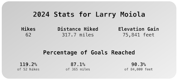
Another trip around the sun! I kept my same hiking goals from previous years: 52 hikes, 365 miles, 84,000 feet. However, I came up short this year, and that's okay. After my trip to Bend, OR in October, I only hiked two more times. I wasn't very consistent counting trail work as hikes: I included some but not others. Happily, I squeezed in a hike up Hamilton Mountain on New Year's Eve.
Some highlights from 2024 were related to my volunteering. This was my second year as a hiking steward with the Mount St Helens Institute and first season as a mentor on the south side of the monument: 83 Road and Ape Cave. I also assisted on some guided hikes: I did the Glacier Overlook Hike three times.
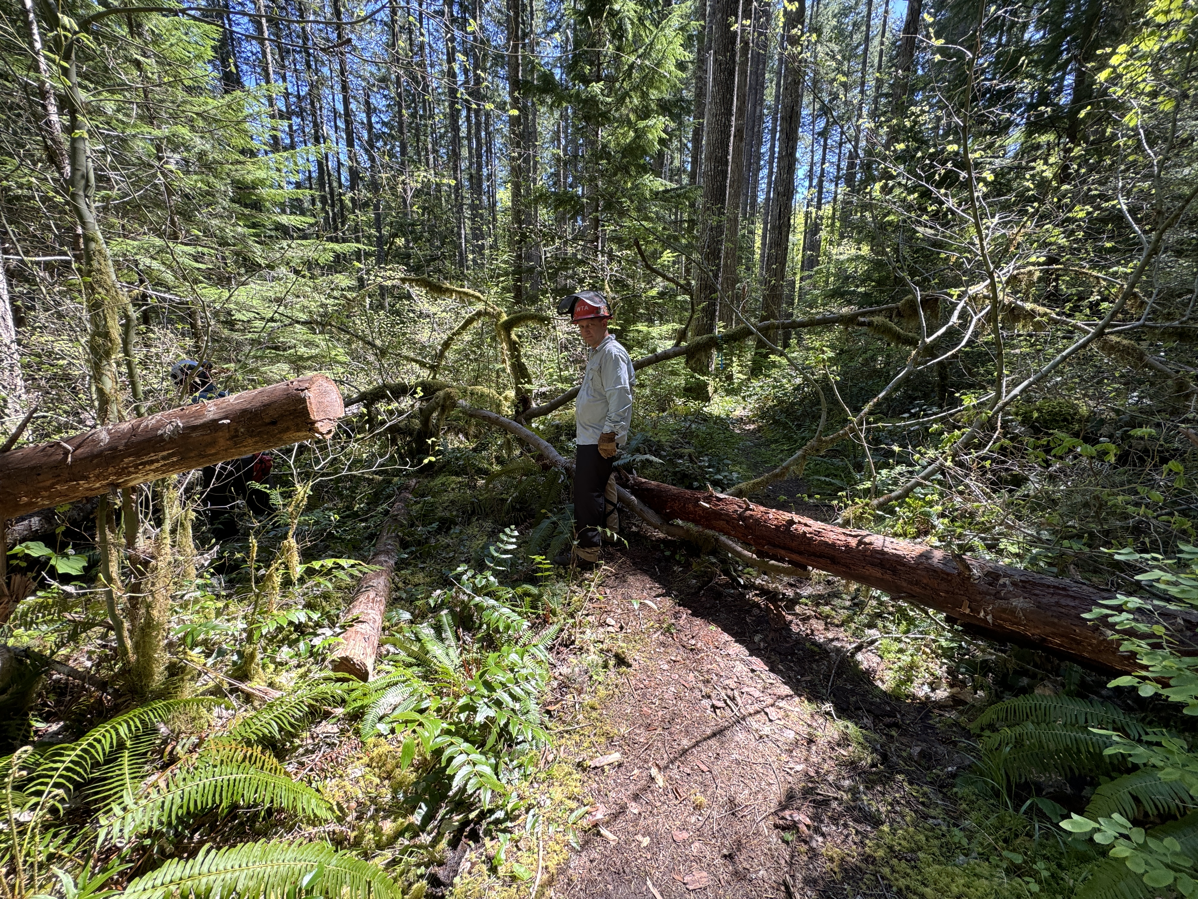
And, I continued to volunteer with Washington Trails Association (WTA) and Trailkeepers of Oregon (TKO), including some multi-day work parties and log outs (as a swamper). I earned my WTA fleece vest in September for doing 25 work parties. In October, I earned my A-level sawyer certification from TKO. I also volunteered with the Cascade Forest Conservancy (CFC), planting trees to improve salmon habitats.
 |
| WTA: Monte Carlo trailhead, WA |
 |
| TKO Sawyer Training: Fish Creek, OR |
 |
| CFC: Camp Creek, WA |
Why 52 hikes?
This description from the last two years is still accurate so why reinvent the wheel. There are a lot of hiking challenges "out there", one being the 52 hike challenge. I thought this aligned well with my new targets and I liked the symmetry with the calendar.
Unlike the previous three years ('21, '22, '23), I didn't do any conditioning hikes in Forest Park & only a few in Beacon Rock State Park, though the latter remains one of my favorite destinations under an hour. These hikes are great for keeping in shape and bumping up my stats.
Why 365 miles?
In 2022, I adjusted my distance goal from 500 miles to 365. I liked the symmetry with the calendar and of course, it works out to 1 mile per day. My hikes have tended to be shorter than usual and my average distance this year is about 6 miles per hike so that means I have to exceed the 52 hikes to reach the mileage goal.
What destinations are 365 miles from Portland?
Mt Shasta, CA is about 365 miles via I-5. It's about the same as a round trip to Seattle, WA (at least by highway).
Elsewhere in the US, for example, it's exactly 365 miles from Moab, UT to Albuquerque, NM.
 |
| Google Maps |
Why 84,000 feet?
This goal was somewhat arbitrary. This works out to 7000 ft per month. 52 hikes at 1600 ft per hike calculates to 83,200 ft. I preferred the symmetry with the number of months in a year. I also knew many of my hikes would be a bit more in the 2000 ft range so I could take some hikes without much elevation gain and still not fall behind on the goals.
What is it like at 84,000 feet high (15.9 mi/25.6 km)?
"At 84,000 feet, MSU’s balloon was above 98 percent of the Earth’s atmosphere." (source)
 |
| Montana State University students |
Reflections
I had some health issues this year that set me back on my hiking goals but I still had a full year of adventure and community service. I'm glad to have reached the summit of Mt St Helens again, as well as explore some new trails.
"When you get to the top of the mountain keep climbing."
-Zen proverb
Mt St Helens Institute (MSHI) [↗]
Volcano Naturalist Program
This was my second year with MSHI as a mountain steward and I wanted to take things up a notch. I spent my Tuesday nights from the end of January to the end of April, plus three field trips. Every week we learned about the geology, flora & fauna, cultural significance, the 1980 eruption and succession from a wide range of scientists, community leaders, and other professionals. It was great to meet others in the program in person for our field trips: MSH Visitor Center, a special visit to Ape Cave in the off-season, and the Hummocks. I did my best to spur conversation during breakouts on Zoom, answer questions about the volunteering, and represent the Institute to fans, supporters, and potential new mountain stewards.


Mountain Steward Training
Just a few weeks after the Naturalist class, training started for volunteers. Even though I hadn't done any shifts at the visitor centers, it was good to go through the all-day Ambassador training and meet other volunteers. A couple weeks after that, we had our Zoom training, followed by the in-person training at Science and Learning Center at Coldwater (SLC). Since I had signed up to be a Mentor, I was tasked to give a brief overview of the role and responsibilities for the south side of the monument. I was nervous in front of the large group and don't remember anything I said. In fact, I forgot to talk about Ape Cave. In the afternoon, we split into groups to do a practice rove on the Hummocks. Another experienced volunteer helped and I channeled my inner Christoph, my mentor. At times, it felt like I wasn't leading very well but we completed the loop and folks seemed happy for the practice.


In June, I had a few mentor shifts scheduled, my first being at Ape Cave. I was glad to only have one person to evaluate. I just did my thing to try to give the new volunteer opportunities to engage and interact with visitors. He gave me a glowing review to the volunteer coordinator. My next mentor session was the following day on the 83 road. I reproduced the route that Christoph had taken us on. We met at the MSHI headquarters in Chelatchie, then caravanned to the Trail of Two Forests. After a short stop there, we continued to the Marble Mountain sno-park. We hiked on the Pine Marten Trail until the washout, then walked the road to the June Lake trailhead. We hiked up to the lake for lunch, then back to our cars. My third mentor shift at Ape Cave didn't get any sign ups so I just treated it like any other shift. My fourth mentor shift was similar to the second one except we explored the Loowit Trail for half mile towards Ape Canyon. We got along well and they both seemed receptive to suggestions and did their best to practice with the visitors we met.
Glacier Overlook Hikes
This year, I was eligible to assist on guided hikes. We had a big training session on the NE side. I'd already spent some time near Randle, so it was great to return. I stopped at the Miner's Car and ran into another MSHI volunteer and the regional crew leader from WTA. We saw some volunteers at the Cascade Peaks Interpretive Center. While driving to Base Camp, I got really woozy. Fortunately, I was on a dirt road, going really slow. I was in shock and downed a bottle of water. WTaF? I made it to camp and tried to brush it off. I didn't want to jeopardize my chances of being on a guided trip. The next morning I did the big group hike to the Glacier Overlook.

The rest of the weekend was fine but I had to pull over somewhere on I-5 (near Castle Rock?) to rest. It turned out to be a case of vertigo, BPPV. Nothing to do except wait it out. Scary!


At the end of August, I had my GOH assistant shift. I camped at Wakepish Picnic Area again. This time I had the place to myself, yikes! After it was dark and I was in my cocoon in the Jeep, I noticed a few cars drive through the parking lot in the wee hours. Because all my stuff was stacked in the front seats, I was a bit vulnerable. Fortunately, no one stayed for long. The weather the next morning was chilly and overcast. Dang, in the middle of August? The view into the crater was mostly obscured but our guests/participants were nonplussed. As a bonus this time, we hiked over to Loowit Falls.
 |
| Mt Adams (Pahto) |
Hiking Steward shifts on 83 Road and Ape Cave
This year, after I did my mentor shifts, I got some quality time on the trails and at the trailheads. For my 83 Road shift, I hit the usual spots: Trail of Two Forests, the Lahar Viewpoint, Lava Canyon, June Lake, and once or twice, a hike up the Ape Canyon Trail. The only new trail that I tackled was the Loowit Trail to Chocolate Falls and back to June Lake via the Pika Trail. It was fun co-roving with Rod and Gail but I would like to prioritize arranging some more co-roving shifts in 2025.
Trail Maintenance
Several volunteers that I know from WTA organized some trail work parties through MSHI and the USFS. The lower section of the Lava Canyon trail, north of the defunct suspension bridge, has been eroding over the years. There was also some re-benching work on the trail between the bridges. It was great to work with friends on some trails within the monument. I also did a co-rove on the Cinnamon Trail resulting in some emergency maintenance by the BCHW, and another on the Fossil Trail, both on the west side of the monument.
Building benches outside SLC
This was my second Conservation Corps shift. It was kind of a long drive for one day but I was glad to chip in. I'd hoped to meet and interact with some other MSHI volunteers but I was the only one who signed up. There was another volunteer there in an ambassador role but I didn't see them after I started the project. I worked in tandem with a USFS employee. The work was a little sloppy but I did my best to minimize the unevenness. I finished the shift at the SLC workshop, sanding the 4x4 timbers for the rest of the benches.
Boots & Bowties
For the second year, I volunteered for the annual fundraiser, Boots & Bowties, at Ilani Casino in Ridgefield, WA. Last year I helped with the silent and live auctions. This year, I was a runner between the box office and accounting booth. I was also a runner for the live auction. I didn't have a chance to talk with other volunteers much but while we were waiting for the live auction to begin, I sat on the floor next to a volunteer I knew by name.
Washington Trails Association (WTA) [↗]
Lyle-Cherry Orchard Trail

Augspurger Trail

Cape Disappointment

The second Cape D trip was in the fall. We all stayed in the Assistant Lighthouse Keeper's Resident at North Head, Fort Canby. I shared a room with another volunteer. Two people stayed in the common area (living room and dining room). Again, we traveled to Astoria for dinners two of the three nights. On the third night, a few of us drove into Long Beach for dinner and stopped at Marsh's Free Museum which has Jake the Alligator Man.


Cispus, Covel Creek
This was my second trip to the Cispus Learning Center near Randle, WA. I stayed there in the spring with Cascade Forest Conservancy. We stayed in one of the bunkhouses, walking distance to the trails. This was my first log out. I was thankful to be included even though I wasn't a certified sawyer. I was the swamper on a small team, participating in the decision making and helping keep my team safe. On the second day, we taxied everyone up Burley Mountain and hiked down. I lost my safety glasses. One of the CLs wasn't feeling well and I volunteered to carry their chainsaw back to camp.
On our second night after most folks had gone to bed, we were enjoying the evening and realized something looked different in the sky. I got out my phone and took a photo. Holy cow! northern lights, aurora borealis! I'd wanted to see them on my Norway trip. The next day we showed our photos and folks were disappointed that we hadn't woken them up. On our third night, we were tasked to sound the alarm if the northern lights happened again. Sadly, they did not. (sad trombone).


On the last day of the work party, a few more folks came up from Portland / Vancouver. Unfortunately, we'd finished the work, except for some cleanup done by a small chainsaw crew. I think we were done by lunchtime. We stopped at the Huff N Puff for a strawberry shake and corn dog.
Cispus, Northfork
This was my second log out work party near the Cispus River. We had a few campsites at the North Fork Campground. Expecting rain, I set up my tent and a new rain cover that extended off the back of my Jeep. I was able to organize my gear, get dressed, change, and extend the livable space when it was pouring. For dinner, we drove into Randle to the Big Bottom Tavern for burgers and drinks. We definitely stood out from the locals.

North Fork Loop
On the first day, we made the short walk to the loop trail. There's a lot of elevation gain at the beginning but a lot of it is flat. We went in the clockwise direction, stopping often to clear debris and fix the trail as needed. We were split into groups of 3 or 4, leapfrogging along the way. We reached a viewpoint and stopped for lunch. I was the swamper and learned a lot about the OHLEC process.


Watchable Wildlife
On the second day, we packed up camp, enjoyed breakfast sandwiches courtesy of the crew leader, then commuted over to NF-25 to Woods Creek Watchable Wildlife loop trail. We split into teams and head out to tackle our task, leapfrogging. It's mostly a flat trail but it was good to get experience with cross cutting. You still follow all the same OHLEC best practices but it takes a bit of finesse, esp. if you're working with another sawyer. I like that the crew leader looks for opportunities for "green hats" to upskill, and it also gives crew-leaders-in-training some more experience leading a team.
 |
| Breakfast |
 |
| Tandem crosscutting |
Olympic Peninsula
For fun, I found a couple one-day WTA work parties on the Olympic Peninsula. It was an excuse for a road trip, camping, sightseeing, and getting to know folks from other regions. My first day was mostly driving up to Sequim to my campground. My neighbors were drunk. I didn't really want to set up much gear, just my tent & sleeping bag, and then got out of there to head up to Port Townsend. I wandered the old part of town for a bit then headed over to Fort Warden and poked around by the lighthouse. I stopped for dinner at the Bayview Restaurant. I thought it was going to be more bougie but it was pretty laid back. I still had some groceries to buy and stopped at a Safeway.
Upper Dungeness
I underestimated the drive to the trailhead. Good thing I didn't stop for breakfast in Sequim. The road was gravel for a bit, but then started to get rutted and narrow. I didn't see any other vehicles so I was worried I'd missed a turn even though I was following the directions from the CL to a tee. I turned a corner and found the parking lot nearly full.
 |
| Debarking |
 |
| Tandem crosscutting |
At this work party, we gathered materials to build a crib wall since the trail got equestrian traffic. We found some small diameter cedars for the "dead men", used a Pulaski and pull knife to remove bark from these huge logs, and did a little crosscutting. The new retired crew leader gave out stickers and homemade cookies at the debriefing.
Mildred Lakes
I didn't have a campsite for my second night. The work site was west of Hamma Hamma and there wasn't anything lodging within a reasonable distance and price. I didn't need much so I drove up to the trailhead. I passed the Lena Lake Trailhead and drove to the end of the road. There was a huge bridge crossing over the Hamma Hamma River. There was a 4x4 camper there with all the windows covered. I didn't want to park next to them so drove back across the bridge and parked within view
but far enough away. I set up my sleeping quarters in the back of the Jeep, too rocky for the tent.

The next morning the camper was still there along with several WTA folks. The work site wasn't less than 1/2 mile from the trailhead, a former logging staging site. The trail originated as a secret fishing trail but was getting more hikers since Lena Lake was too crowded in the peak summer season. Our goal was to widen the tread, no easy task as it was totally rocky. It took the whole day to reconfigure a 20 foot section.

It was good to meet and work with new folks. I saw a guy from the previous day that earned his 500 day sticker. I thought I might run into another guy from Olympia that I've worked with at the coast and Cispus.
Monte Cristo, Monte Carlo
Even though the Williams Mine fire was still going near Mt Adams & Trout Lake, the smoke had not drifted to where we were camped at the Oklahoma Campground. We had a small but mighty crew. On the first day, we carpooled to the work site but our crew leader didn't explain the directions. We had two cars heading to the lower trailhead, a road that gets more narrow, overgrown as you go. At a certain point, we realized we were lost. We managed to turn around and head back toward the campground. We were intercepted and got directions. We drove up the overgrown forest road, clearing branches & debris. When we got to the end of the road, we set out on foot to continue. When we ran out of stuff, in the mid-afternoon we dropped our gear and hiked to the top of the mountain.

That night at camp, one guy dreamed about getting a burrito. It didn't take much convincing to ditch my MRE and give my order. Oliver got in his car and disappeared. We waited and waited and waited. We joked that he'd made off with our cash and gone on vacation. Turns out the place he'd wanted to go was closed so he drove all the way to Hood River and found another place. The food was awesome, just what the doctor ordered.

The next day, our focus was on the Monte Carlo trail. The trailhead was just across the forest from out campsite. We parked along the road and started brushing. No views today. I had a chance to sit with Janene for lunch. She is a "lunch lady" (cafeteria manager at a school). We talked about nutrition and her work as a crew leader. It's great to walk back through the sections that had been cleared and notice the improvement. We may not see the visitors that benefit from the work but it's rewarding just the same. At the debriefing, I got my fleece WTA vest for completing my 25th day of service.
Trailkeepers of Oregon (TKO) [↗]
My work with TKO has been pretty limited. I did one trail party and one Ambassador shift in 2023, both at Latourell Falls. The rest of my volunteering was spent with WTA and MSHI.


In March, I did my first work party for 2024 at Troutdale/Beaver Creek. It was a continuation of work to rebuild the stairs. The group I was with included my buddy from WTA, building the boxes for the steps with 6x6 timbers and rebar. We only made 4 or 5 steps but it was good, honest work. I was tired at the end of the shift, the good kind of tired.
 After working on a couple log out work parties with WTA, I started looking for an organization to get my chainsaw/sawyer certification. I found the PCT Association and the Backcountry Horsemen chapters in WA and OR but no upcoming classes. Fortunately, in October there was a three-day class through TKO that was open to anyone that had volunteered any number of hours. It was one day of classroom instruction and two days of field training. One of the evaluators was someone I know from WTA.
Thanks to TKO for offering the class, I earned my "A" sawyer certification. I feel a duty to repay the debt and plan to find a log out to get some trigger time and give back to the TKO. Whatever I end up doing, I'm glad to give back to my PNW community.
Cascade Forest Conservancy (CFC) [↗]
Another organization that I donated some time and energy was the CFC. In my mind, it completes the complimentary triad of organizations that care for the forests and trails in the PNW. While I interact with people in my role with MSHI, care for the trails with WTA, I'm helping to restore damaged habitats with CFC.
Yellowjacket Creek

Stump Creek
It wasn't until November that I was able to sign up for some more shifts, in fact, it was their last two outings of the year. We met at park south of Toutle, WA to consolidate into fewer vehicles. In fact, our worksite was about 30 miles east on a narrow forest road. It was raining and cold but we planted hundreds of Sitka spruce saplings.
Camp Creek & Crystal Creek

The following Saturday, I joined the last riparian planting party. We met at the Cowlitz Ranger Station in Randle, WA. This outing involved two stops: Camp Creek off Cispus Road, and Crystal Creek off NFD-25. We harvested hundreds of willow stakes and planted half of them along the banks of Crystal Creek. Then, we hopped in our cars and drove to Crystal Creek and planted the other half of the willow stakes.
We harvested hundreds of willow stakes and planted half of them along the banks of Crystal Creek. Then, we hopped in our cars and drove to Crystal Creek and planted the other half of the willow stakes.
Mt St Helens Summit
For the fourth year in a row, I took another run at the summit. I felt strong and had plenty of snacks and electrolytes. I also ate much better the night before. I parked where I did the first year I did the climb: it worked, I made it to the rim again!
In the morning (around 6am), I started out hiking by myself but by the first section of rocks, I started to see more climbers. I met a guy that was making his first ascent and commented on the clear skies. On the first rocky traverse, I stopped to put on some layers because the wind kicked up and some clouds had rolled in. I apologized for jinxing the weather.
While going through the boulders, I noticed that there were a dozen or so other hikers on the route. The wind had died down and the sun was back out. I could make out shapes of people on the summit.
As I ascended the last section, I counted off the steps in sets of twenty until I reached the rim and could see Spirit Lake and Mt Raininer. It was both exciting and a huge relief.
Read the full blog post: https://roadtripsandhikes.blogspot.com/2024/09/hike-mt-st-helens-summit-cougar-wa.html
Trip to Bend in October
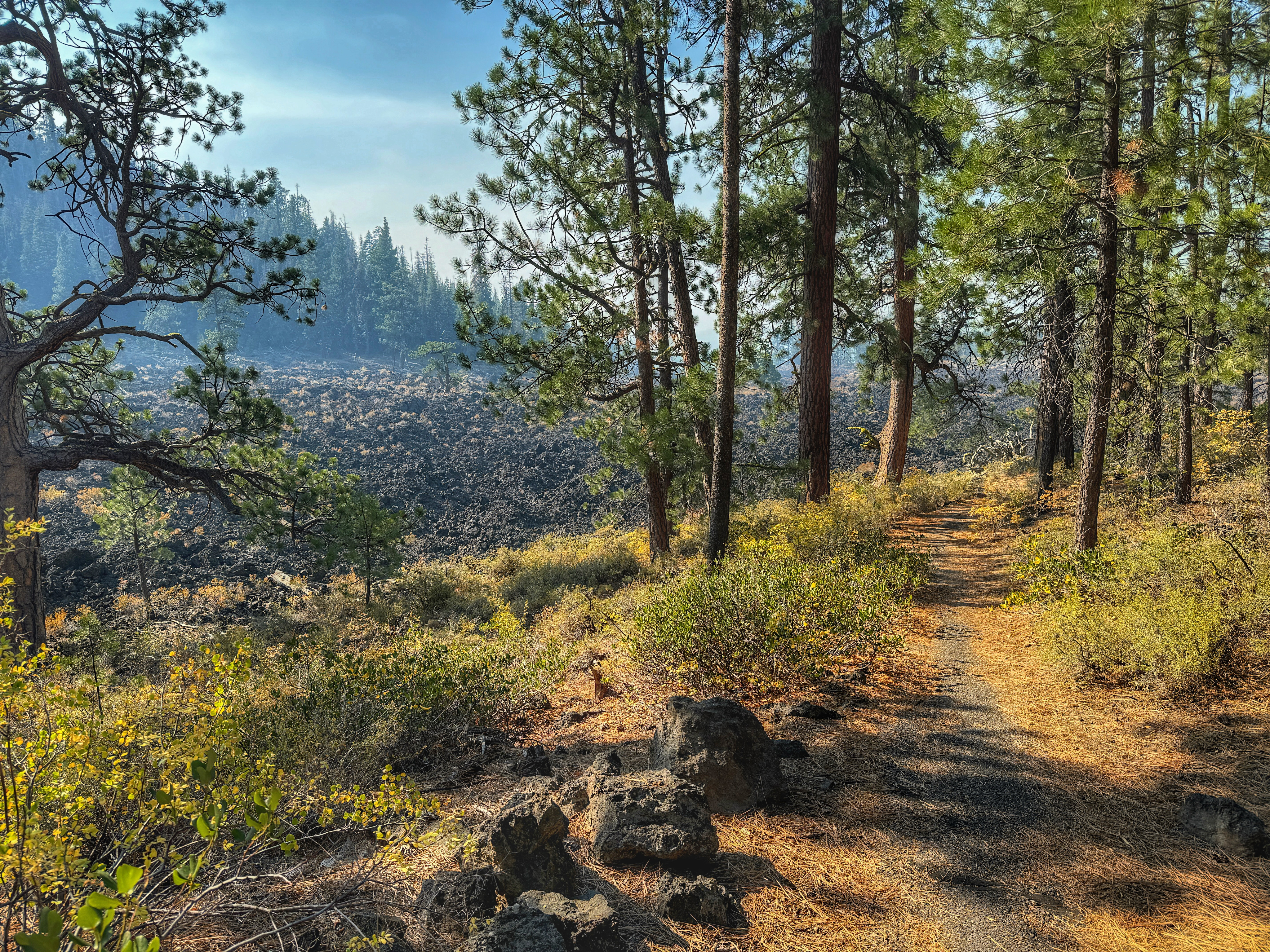
Lava Cast Forest
While I expected this trail was similar to the Trail of Two Forests within the Mt St Helens Volcanic Monument, I found similarities and differences. Instead of a boardwalk, this is an asphalt paved trail within Newberry Volcanic Monument. There are trees embedded in the lava and had not burned away. There were dozens of gnarled, twisted trees that had survived the lava flow but there were plenty of tree cast holes where ancient trees had once stood. The trail winds through a stand of trees, adjacent to a massive lava field. You got a real sense of scale with Newberry Caldera within view to the south.

Newberry Caldera
This was my second visit to the caldera and I headed right up to Paulina Peak. I was the only car up there besides the port-a-potty truck. I took the same photos that I did the previous year and hiked down the interpretive trail. I could see wildfire smoke from the south drifting into the caldera. I hadn't accounted for the fire season when I scheduled this impromptu trip to Bend. From there, I headed to the boat launch on the edge of East Lake. The smoke was really getting dense and I was losing daylight. I didn't even have time to stop at Big Obsidian Flow. I felt rushed but was glad I'd made it up there. I realized that I'd driven toward the worst of the wildfires; the air quality in La Pine was purple, meaning hazardous, go indoors.


Trail of Molten Lands
When I got back on Hwy 97, I was relieved to find clear air up by Sunriver. I passed Lava Butte and had to drive all the way to South Bend to make a u-turn. There was still some daylight left and I wanted to check out the cinder cone again. The road was closed but I could still take a quick spin around the Trail of the Molten Land. The bank of wildfire smoke was steadily moving north. It made the sunset golden. I got back to the car just in time for the sun to drop below the horizon.


Smith Rock
I'd planned to stop at Smith Rock on my way home but the area's wildfire smoke was still lingering and limiting my hiking options. The AQI near Redmond looked a lot better. After grabbing some coffee, I headed north on Hwy 97. Wow! As soon as I pulled into the parking lot, I was awestruck. In my usual fashion, I had done zero research on the trail system and just started going towards the visitor center + gift shop, both closed. Before descending into the canyon, I spied a trail climbing up the side of the rock that disappeared around the corner. I was going there! And what an epic one it was, the Misery Trail. When it was time to choose my return route on the backside of the rocky formation past Monkey Face, I sought solitude and more miles. I eventually found my way to the Burma Road trail and could see the visitor center. I ended my trek with a short out-n-back hike along the Crooked River, where there were several groups of rock climbers taking turns on their respective chalky routes. Truly epic visit.


No Name Lake & Bend Glacier
I was determined to make it to the trailhead this time. If something is gonna break, so be it, but I knew my rig was up to the challenge. From the Todd Creek Trailhead, it's about 5 miles on a moderately rutted dirt road. I knew the views were going to be awesome. It took about 40 mins but I found a nearly full parking lot, including some cars that had much lower clearance than I did. I met a guy in the parking lot that was meeting a friend who was biking from Broken Top Brewery in Bend: they were meeting at Broken Top summit.
 |
| Broken Top Mountain |
 |
| No Name Lake |
The views of Three Sisters, Mt Washington, Three Finger Jack, and more from that upper rim was just incredible. I knew I still had to drive back to Portland so I didn't stay as long as I would have liked. I met some backpackers that were going on a multi-day hike past Broken Hand and The Tam McArthur Rim. Next time!
 |
| Three Sisters |
Other new trails
These are all hikes on trails that I hadn’t been to before. They are more or less arranged in chronological order. I tend to return to favorite trails for conditioning hikes but I want to get better at exploring new places.
Sahalie Falls

Historic Columbia River Highway State Trail

Falls Creek Falls

Pika Trail (via June Lake)

Toutle & Cinnamon Loop

Tamanawas Falls

Cloud Cap Inn

Fossil Trail

Kalama Falls

Packwood Lake

What's Next
• More volunteering with MSHI, WTA, TKO
• Climb Mt Adams, Mt St Helens, another mountain TBD
• Return to north side of Mt Hood (Tilly Jane, Cooper Spur, Barrett Spur)
• More road trips; visit other volcanic areas: Craters of the Moon, Parkdale Lava Flow,
return to Lassen Volcanic National Park, Lava Beds National Monument
• More snowshoeing in Oregon, Washington
• Explore more Gorge hikes: Nesmith Point, Mount Defiance, Herman Creek,
Tunnel Falls, Table Mountain
Overall Stats for the Year
• Number of Hikes: 62
• Total Distance: 317.7 miles (511.3 km)
• Total Elevation Gain: 75,841 feet (23,116 m)
• Average Distance per Hike: 5.12 miles (8.24 km)
• Average Elevation Gain per Hike: 1,223 feet (372.8 m)
• Longest Hike: 10.77 miles (Ape Canyon, 8/10/2024)
• Highest Elevation in a Hike: 8,260 feet (Mt St Helens, 9/16/2024)
• Most Elevation in a Hike: 4,531 feet (Mt St Helens, 9/16/2024)
Check out these platforms for updates and photos


